EBSA Status Assessment and Management Recommendations
Ecological Condition, Threat Status, Current Protection and Key Features in the EBSA
Relevant Pressures and Activities (impact, extent) | Management Interventions Needed for the EBSA
Activity Evaluation Per Zone: Zoning Feasibility | Research Needs & Future Process
Back to the Namibian EBSA status and management home page
Walvis Ridge Namibia encompasses the globally rare connection of a hotspot track (seamount chain formed by submarine volcanism) to continental flood basalt. The high habitat heterogeneity is likely to support rich biological diversity, including vulnerable, fragile species and demersal fish associated with seamounts. The area also has enhanced productivity from upwelling. It is largely undisturbed and mostly in a natural state.
Click here for the full EBSA description
[Top]
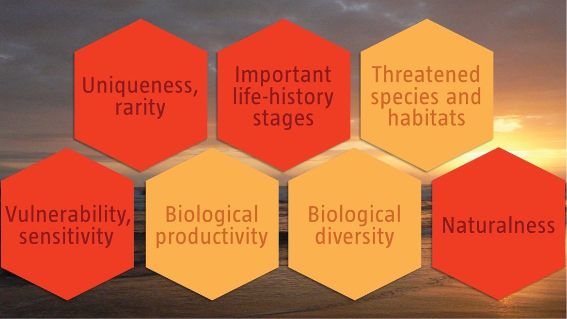
Walvis Ridge Namibia has multiple ecological features and different ecosystem types that need to be protected for the area to maintain the characteristics that give it its EBSA status. The criteria for which this EBSA ranks highly are: uniqueness and rarity; importance for life-history stages; vulnerability and sensitivity; and naturalness. There are 10 ecosystem types represented, including two Vulnerable types (Central Namib Shelf Edge and Cunene Shelf Edge). Walvis Ridge Namibia encompasses the globally rare connection of a hotspot track to continental flood basalt. Given the high habitat heterogeneity associated with the complex benthic topography, it is likely that the area supports a relatively higher biological diversity and is likely to be of special importance to vulnerable sessile macrofauna and demersal fish associated with seamounts. Productivity in the Namibian portion of Walvis Ridge is also relatively high because of upwelling.
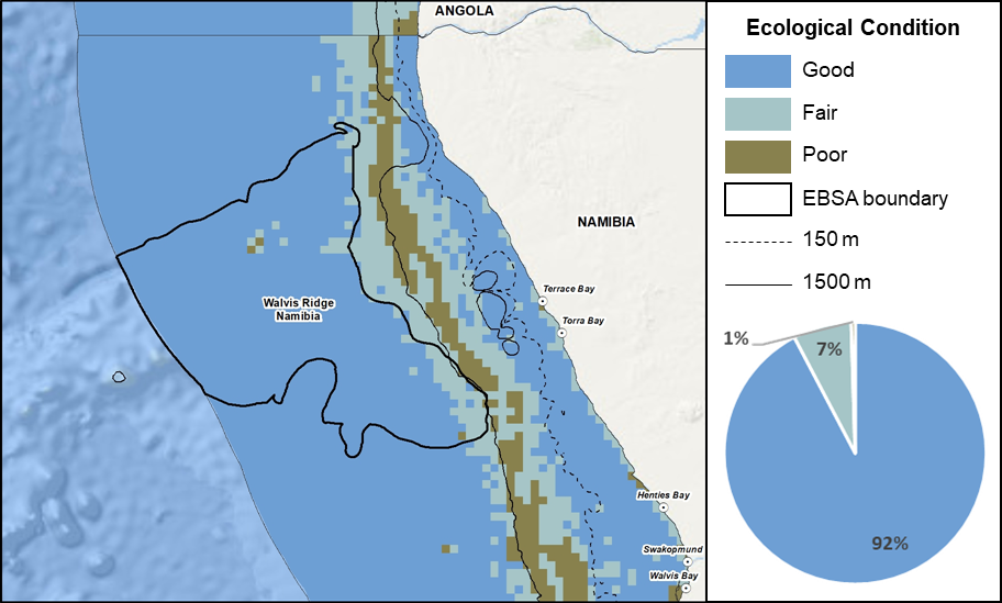
Walvis Ridge Namibia proportion of area in each ecological condition category.
Walvis Ridge Namibia is in good (92%) to fair (7%) ecological condition, with only 1% in poor ecological condition. Consequently, all but two ecosystem types are Least Concern, comprising 65% of the EBSA extent. The two Vulnerable ecosystem types (Central Namib Shelf Edge and the Cunene Shelf Edge) comprise the other third of the area (35%). Currently, there are no MPAs in Walvis Ridge Namibia, and consequently, all ecosystem types are Not Protected.
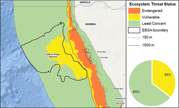
Walvis Ridge Namibia proportion of area in each ecosystem threat status category.
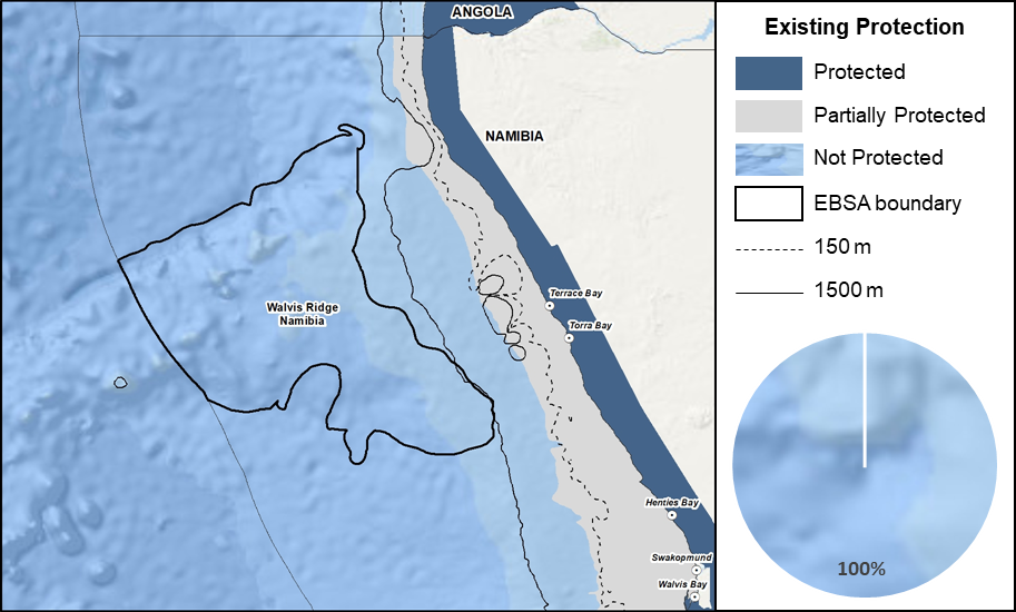
Walvis Ridge Namibia proportion of area in a Marine Protected Area (MPA).
Threat status, protection level and ecological condition of ecosystem types in the EBSA. Other key features are also listed.
|
Feature
|
Threat Status
|
Protection Level
|
Condition (%)
|
|
Good
|
Fair
|
Poor
|
|
Ecosystem Types
|
|
Central Namib Shelf Edge
|
VU
|
NP
|
100.00
|
0.00
|
0.00
|
|
Cunene Abyss
|
LC
|
NP
|
95.22
|
4.78
|
0.00
|
|
Cunene Lower Slope
|
LC
|
NP
|
85.56
|
10.18
|
4.26
|
|
Cunene Seamount
|
LC
|
NP
|
88.68
|
11.32
|
0.00
|
|
Cunene Shelf Edge
|
VU
|
NP
|
89.24
|
10.76
|
0.00
|
|
Cunene Upper Slope
|
LC
|
NP
|
100.00
|
0.00
|
0.00
|
|
Namib Abyss
|
LC
|
NP
|
100.00
|
0.00
|
0.00
|
|
Namib Lower Slope
|
LC
|
NP
|
100.00
|
0.00
|
0.00
|
|
Namib Seamount
|
LC
|
NP
|
97.19
|
1.19
|
1.62
|
|
Namib Upper Slope
|
LC
|
NP
|
100.00
|
0.00
|
0.00
|
|
Other Features
|
-
Sessile macrofauna and demersal fish associated with seamounts
-
Orange Roughy
-
Seabirds
|
[Top]
-
There are six pressures present in this EBSA, of which large pelagic longline (tuna longline), covers the largest portion and has the highest cumulative pressure profile. Shipping is the only other major pressure, with hake trawling (freezer and wet), crab harvesting and tuna pole fishing also present, but only in a very small proportion of the EBSA. The EBSA delineation has largely avoided intense fishing areas, particularly on the shelf edge.
-
Most of the activities take place within the proposed Impact Management Zone, except for shipping and pelagic longlining that have a notable footprint in the Conservation Zone.
-
As a deep-water EBSA, inshore pressures such as seal harvesting, mariculture, coastal development, and ports are not present.
-
Note that small pelagics fishing used to be present in this area, but is no longer an active industry in Namibia; similarly, trawling for Orange Roughy used to take place in this EBSA but the species is now commercially extinct and the fishery no longer operates in Namibia.
-
Note also that this assessment of pressures is based on existing data. Where new, finer scale data have since become available, these are presented below (e.g., for shipping and combined fisheries) to enable more accurate recommendations for management of activities. Also, there are some emerging activities and activities for which no spatial data are available that are not included here, but are considered in the management recommendations for the EBSA, based on expert and industry information.
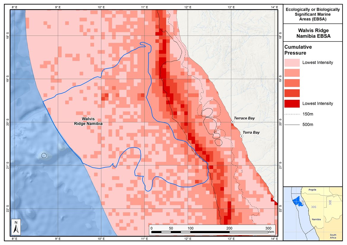
Map of cumulative pressure from all activities in the EBSA and surrounds. Darker reds indicate higher pressure intensity.
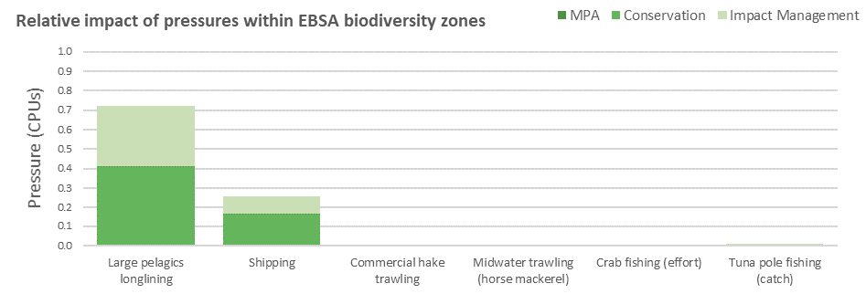
Pressure (in arbitrary cumulative pressure units, CPUs) summed for each pressure in the EBSA, per proposed EBSA biodiversity zone, ranked left (highest) to right (lowest) by the overall relative importance of pressures in this EBSA. Note that pressures from commercial hake trawling to tuna pole fishing each comprise <1% of the EBSA pressure profile.
[Top]
Improved place-based protection of EBSA features should be pursued. In support of this, the EBSA is divided into a Conservation Zone and an Impact Management Zone, both comprising several areas within the EBSA. The aim of the Conservation Zone is to secure core areas of key biodiversity features in natural / near-natural ecological condition. Strict place-based biodiversity conservation is thus directed at securing key biodiversity features in a natural or semi-natural state, or as near to this state as possible. Activities or uses that have significant biodiversity impacts should be prohibited. Where possible and appropriate these areas should be considered for formal protection e.g., Marine Protected Areas or other effective area-based conservation measures (OECM). The aim of the Impact Management Zone is to manage negative impacts on key biodiversity features where strict place-based measures are not practical or not essential. In this zone, the focus is management of impacts on key biodiversity features in a mixed-use area, with the objective to keep biodiversity features in at least a functional state. Activities or uses which have significant biodiversity impacts should be strictly controlled and/or regulated. Within this zone, there should be no increase in the intensity of use or the extent of the footprint of activities that have significant biodiversity impacts. Where possible, biodiversity impacts should be reduced. As far as possible, the Conservation Zone was designed deliberately to avoid conflicts with existing activities. Note that there are no marine protected areas in this EBSA.
Proposed zonation of the EBSA into Conservation (medium green) and Impact Management (light green) Zones. MPAs are overlaid in orange outlines, with the extent within the EBSA given in dark green. Click on each of the zones to view the proposed management recommendations.
[Top]
Protection of features in the rest of the Conservation Zone may require additional Marine Protected Area declaration/expansion. Other effective conservation measures should also be applied via Marine Spatial Planning to ensure that the existing activities/uses are appropriately controlled to ensure compatibility of activities with the environmental requirements for achieving the management objectives of the EBSA Conservation and Impact Management Zones. Further, no new pressures should be extended into the Conservation Zone, even if they currently occur in the Impact Management Zone of the EBSA.
Recommended compatibility (consent1 or prohibited2) of activities currently present in the EBSA3 in the Conservation and Impact Management Zones
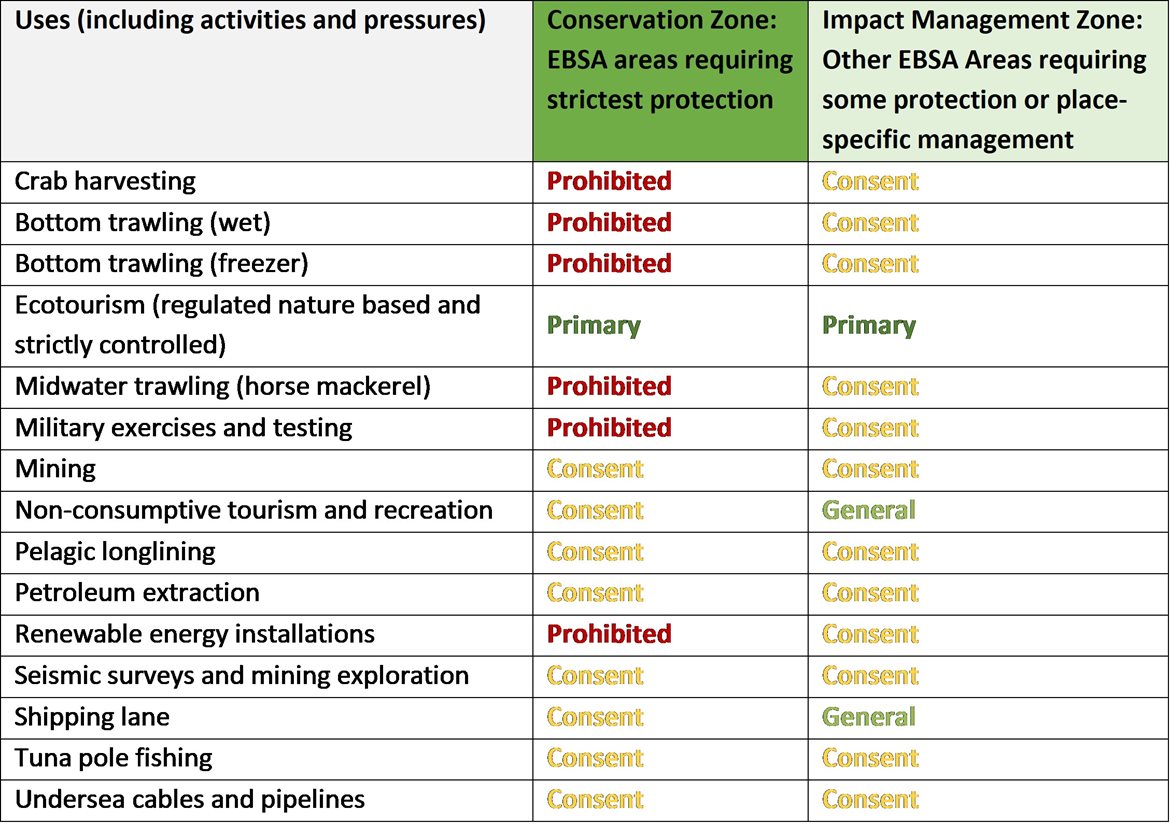
2Prohibited: An activity which is not allowed or should not be allowed because it is incompatible with maintaining the biodiversity objectives of the zone.1Consent: An activity which can continue in this zone subject to specific regulation and control.
3Note that activities present in Namibia that are not relevant to the EBSA have been excluded from the table (e.g., the harvested species does not occur in the area; or the industry operates at a depth outside the depth range of the EBSA).
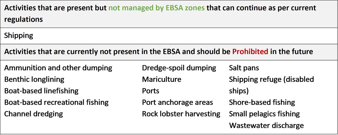
Furthermore, no new activities that can negatively impact the environment should be allowed in the EBSA, and some activities present in the EBSA do not need to be managed by EBSA zoning and can continue as per the current regulations. There are also some pressures on biodiversity features within the EBSA that originate from activities outside of these EBSA or beyond the jurisdiction of MSP. In support of maintaining the ecological integrity of and benefits delivered by the key biodiversity features, these other activities need to be appropriately managed by complementary initiatives.
Recommendations for other activities outside the EBSA or the MSP management jurisdiction.
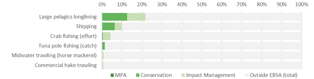
Proposed zonation of the EBSA, with the cumulative intensity footprint of activities within the EBSA (sorted highest to lowest) given relative to the national footprint of those activities to illustrate feasibility of management interventions.
Pelagic longlining in Walvis Ridge Namibia comprises more than a fifth (22%) of the national footprint of this activity, where it is split almost equally between the Conservation and Impact Management Zones. Given its economic importance and that it is a non-destructive fishery, it is therefore recommended that it is a Consent activity in both EBSA zones, recognising that bycatch mitigation is key for this activity to remain compatible with the management objectives of the EBSA, especially in the Conservation Zone. The other fisheries have a very small component of their respective national footprints (<5%) in the EBSA. Crab harvesting and midwater trawling (horse mackerel) are non-destructive fisheries and are recommended to be Prohibited in the Conservation Zone and Consent in the Impact Management Zone. Tuna pole fishing is a selective fishery, and is therefore recommended to be a Consent activity in both zones. Shipping can continue in both the Conservation and Impact Management Zones under current general rules and legislation, however, there might need to be some control and regulation for shipping lanes in the Conservation Zone, where it is recommended to be a Consent activity. Other activities noted in the table of management recommendations above are either not currently present in the EBSA or are emerging activities; as far as possible, these are accommodated in the EBSA, depending on their compatibility with the management objectives of the two zones. Thus, the EBSA zonation has no or minimal impact on the national footprint for the listed marine activities.
Research Needs
Given the extent of Walvis Ridge, and how far it runs into the high seas, research on this feature is largely limited to collaborative cruises that combine physical and biological sampling, usually over a small area. Despite the numerous species records, only a fraction of the EBSA has been sampled, and any new information and data on the system advance our knowledge and understanding of Walvis Ridge. Research should possibly be prioritised in areas where activities are potentially interacting, or will likely interact, negatively with key biodiversity features, e.g., fishing overlaps with known or presumed vulnerable, fragile ecosystems, or threatened species. However, large-scale research in understanding the role of this outstanding feature in the global geophysical processes (including oceanic and climatic processes) will also be key to unlocking future predictions under different climate change scenarios. Alignment between the research and management of the Namibian EEZ and the high seas portions of the Walvis Ridge system will be critical for long-term sustainability. See also the general research needs for all EBSAs.
Future Process
Proposed zoning needs to be included in the northern MSP when undertaken.
It remains the intent to secure a single unified EBSA incorporating the Walvis Ridge Namibia and the existing high seas Walvis Ridge EBSA. The delineation of the Walvis Ridge Namibia EBSA is more precise than the delineation of the existing high seas Walvis Ridge EBSA; which results in a much closer alignment between the EBSA boundary and the underlying features it represents along the Ridge. If the Walvis Ridge Namibia EBSA and the high seas Walvis Ridge EBSA are to be aligned in the future, it will be necessary to update the boundaries of the integrated EBSA.
References
UNEP-WCMC, IUCN, 2022. Protected Planet: The World Database on Protected Areas (WDPA) and World Database on Other Effective Area-based Conservation Measures (WD-OECM) [Online], September 2022. UNEP-WCMC and IUCN, Cambridge, UK. Available at: www.protectedplanet.net.
[Top]