|
Data used in the analyses below (ecological condition, threat status, protection, distribution of activities, cumulative pressure from activities) are from the National Biodiversity Assessment 2018: Marine Realm Assessment. See the NBA 2018 website for access to the report.
|
EBSA Status Assessment and Management Recommendations
Ecological Condition, Threat Status, Current Protection and Key Features in the EBSA
Relevant Pressures and Activities (impact, extent) | Management Interventions Needed for the EBSA
Activity Evaluation Per Zone: Zoning Feasibility | Management recommendations for MPAs
Management recommendations for MSP | Research Needs & Future Process
EBSA report download | Back to the SA EBSA status and management home page
Algoa to Amathole encompasses the likely biggest single collection of significant and special marine features in all of South Africa that also jointly support key ecological processes, including important land-sea connections. It is a productive, diverse area that contains rare and unique features and species, and is especially important for several threatened species, notably seabirds, that breed, rest and forage within the EBSA.
Click here for the full EBSA description
[Top]
Algoa to Amathole has a particularly rich collection of features and ecosystem types that need to be protected for the area to maintain the features and processes that give it its EBSA status. There are 36 ecosystem types represented, of which the mosaics, rocky shores, rocky shelf and shelf edge, canyons and Amathole Lace Coral ecosystem types and contain fragile species that are especially sensitive to damage. The EBSA also includes Algoa Bay, four islands and several rocky islets, stromatolites, and several priority estuaries also include some sensitive species, contribute to numerous ecological functions, and contribute to a particularly rich diversity in this EBSA.
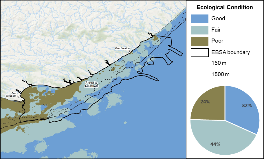
Algoa to Amathole proportion of area in each ecological condition category.
Algoa to Amathole is largely in good (32%) to fair (44%) ecological condition, with a quarter (24%) in poor ecological condition, mainly linked to the development and economic nodes at Port Elizabeth and Port Alfred. Consequently, the bulk of the offshore extent is either Vulnerable (42%) or Near Threatened (21%), with only a fraction (1%) that is Endangered, and the rest, Least Concern (36%). The Endangered ecosystem types cluster at the Kei mouth, and/or contain fragile species: Kei Fluvial Fan; Kei Reef Mosaic and Agulhas Sheltered Rocky Shore.
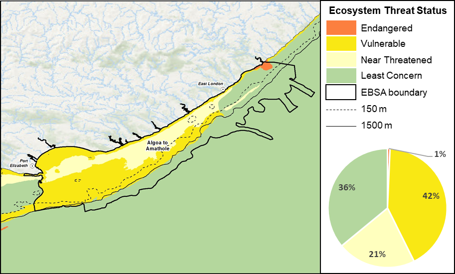
Algoa to Amathole proportion of area in each ecosystem threat status category.
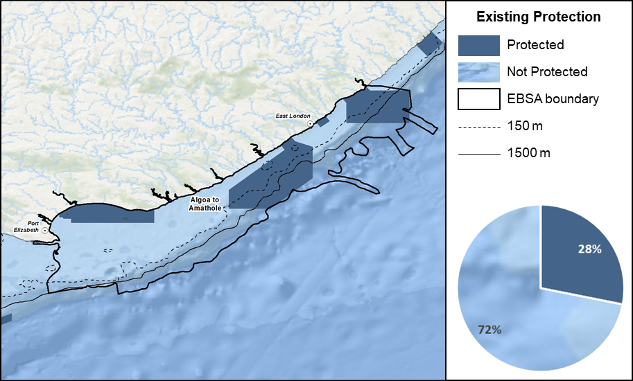
Algoa to Amathole proportion of area in a Marine Protected Area (MPA).
Protection of features in MPAs has been considerably expanded and strengthened following the proclamation of the Operation Phakisa MPA network, with the EBSA area within reserves increasing by more than an order of magnitude from <2% to 28%. These new MPAs cover the eastern end of Algoa Bay, and offshore areas in Amathole, protecting key (fragile and/or threatened) species, important life-history stages and many ecosystem types.
Threat status, protection level and ecological condition of ecosystem types in the EBSA. Other key features are also listed.
|
Feature
|
Threat Status
|
Protection Level
|
Condition (%)
|
|
Good
|
Fair
|
Poor
|
|
Ecosystem Types
|
|
Agulhas Boulder Shore
|
NT
|
WP
|
56.9
|
20.3
|
22.8
|
|
Agulhas Coarse Sediment Shelf Edge
|
VU
|
PP
|
36.0
|
31.0
|
33.0
|
|
Agulhas Dissipative Intermediate Sandy Shore
|
LC
|
WP
|
72.0
|
13.6
|
14.4
|
|
Agulhas Dissipative Sandy Shore
|
NT
|
WP
|
46.0
|
26.2
|
27.8
|
|
Agulhas Exposed Rocky Shore
|
VU
|
MP
|
23.5
|
19.1
|
57.4
|
|
Agulhas Exposed Stromatolite Rocky Shore
|
VU
|
PP
|
11.9
|
58.4
|
29.7
|
|
Agulhas Inner Shelf Mosaic
|
VU
|
MP
|
10.7
|
26.0
|
63.3
|
|
Agulhas Intermediate Sandy Shore
|
LC
|
MP
|
42.9
|
29.8
|
27.4
|
|
Agulhas Island
|
VU
|
WP
|
91.4
|
0.4
|
8.2
|
|
Agulhas Lower Canyon
|
LC
|
MP
|
57.8
|
42.2
|
0.0
|
|
Agulhas Mid Shelf Mosaic
|
NT
|
MP
|
11.0
|
81.4
|
7.7
|
|
Agulhas Mid Shelf Reef
|
VU
|
MP
|
0.0
|
15.8
|
84.2
|
|
Agulhas Mixed Shore
|
NT
|
MP
|
22.1
|
45.3
|
32.6
|
|
Agulhas Sandy Inner Shelf
|
VU
|
MP
|
16.4
|
67.3
|
16.2
|
|
Agulhas Sandy Mid Shelf
|
NT
|
MP
|
2.5
|
58.0
|
39.5
|
|
Agulhas Sandy Outer Shelf
|
VU
|
PP
|
12.4
|
46.7
|
41.0
|
|
Agulhas Stromatolite Mixed Shore
|
VU
|
MP
|
12.4
|
61.7
|
25.9
|
|
Agulhas Upper Canyon
|
VU
|
WP
|
20.7
|
79.3
|
0.0
|
|
Agulhas Very Exposed Rocky Shore
|
VU
|
MP
|
18.9
|
77.8
|
3.3
|
|
Agulhas Very Exposed Stromatolite Rocky Shore
|
NT
|
MP
|
98.1
|
1.9
|
0.0
|
|
Amathole Hard Shelf Edge
|
VU
|
WP
|
21.9
|
75.6
|
2.5
|
|
Amathole Lace Corals
|
NT
|
MP
|
30.8
|
69.2
|
0.0
|
|
Eastern Agulhas Bay
|
VU
|
MP
|
10.8
|
29.0
|
60.2
|
|
Kei Fluvial Fan
|
EN
|
MP
|
0.1
|
65.7
|
34.2
|
|
Kei Reef Mosaic
|
EN
|
MP
|
0.0
|
21.7
|
78.3
|
|
Natal Deep Shelf Edge
|
LC
|
MP
|
70.0
|
30.0
|
0.0
|
|
Natal Lower Canyon
|
LC
|
WP
|
99.9
|
0.1
|
0.0
|
|
Southwest Indian Mid Slope
|
LC
|
PP
|
78.6
|
21.4
|
0.0
|
|
Southwest Indian Upper Slope
|
LC
|
WP
|
79.8
|
20.2
|
0.0
|
|
Warm Temperate Large Fluvially Dominated
|
VU
|
PP
|
1.5
|
59.4
|
39.1
|
|
Warm Temperate Large Temporarily Closed
|
VU
|
PP
|
23.7
|
40.8
|
35.6
|
|
Warm Temperate Micro-estuary
|
NA
|
NA
|
61.1
|
30.2
|
8.7
|
|
Warm Temperate Predominantly Open
|
VU
|
PP
|
3.9
|
43.5
|
52.6
|
|
Other Features
|
-
Numerous cetacean species, including mother-calf pairs of whales during particular seasons and the largest pods of bottlenose dolphins in the world
-
Numerous seabird species, many of which are threatened, notably the African penguin colony at St Croix Island and the Cape gannet colony at Bird Island
-
Seals, sharks and turtles
-
Fragile reef-associated species, e.g., corals and sponges
-
Stromatolites
-
Accumulations of surf diatoms
-
Sites where coelacanths are present
-
Critically Endangered localised endemic estuarine pipefish
-
Several priority estuaries
|
[Top]
-
There are 23 pressures present in this EBSA, of which shipping is the only one that covers the entire EBSA extent and has the highest cumulative pressure profile.
-
Key pressures in this EBSA that most directly impact the features for which the EBSA is described include: linefishing, harvesting south coast rock lobster harvesting, inshore and offshore trawling, squid fishing. There are also several other fisheries operating in the area, but these are less intensive and have a smaller footprint within the EBSA. The key pressures cover discrete portions of the EBSA, and are mostly concentrated in the shallower waters. These activities will need to be managed particularly well in order to protect the fragile benthic biodiversity, nursery habitats, and fish assemblages for which this EBSA is recognised. The larger portion of these activities is in the Impact Management Zone.
-
Coastal development, ports and harbours comprise small portions of the EBSA, but they are notable drivers of many of the other pressures that are present in the EBSA.
-
Thirteen of the 23 pressures each comprise <1% of the EBSA pressure profile, including: alien invasive species; mean annual runoff reduction; benthic (hake) longlining; coastal disturbance; coastal development; wastewater discharge; oil and gas (exploration and production); recreational shore angling; abalone harvesting; subsistence harvesting; mariculture; naval dumping (ammunition); and oyster harvesting.
-
Activities in South Africa that are not present in this EBSA include: mining (prospecting and mining); kelp harvesting; tuna pole fishing; gillnetting; west coast rock lobster harvesting; prawn trawling; shark netting; dredge spoil dumping; and beach seining.
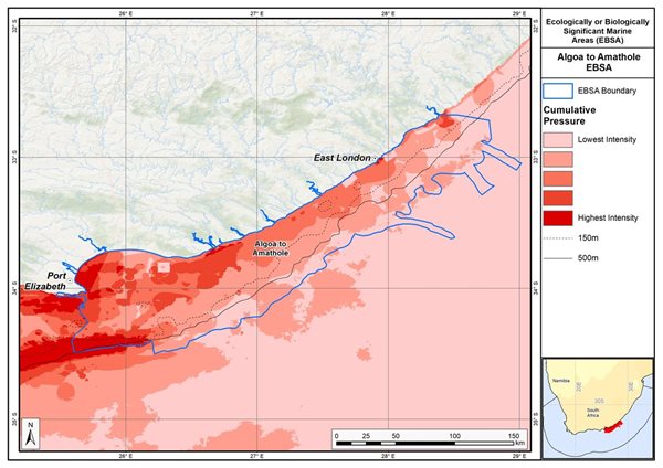
Map of cumulative pressure from all activities in the EBSA and surrounds. Darker reds indicate higher pressure intensity.
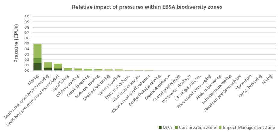
Pressure (in arbitrary cumulative pressure units, CPUs) summed for each pressure in the EBSA, per proposed EBSA biodiversity zone, ranked left (highest) to right (lowest) by the overall relative importance of pressures in this EBSA. Note that pressures from alien invasive species to oyster harvesting each comprise <1% of the EBSA pressure profile.
[Top]
Improved place-based protection of EBSA features should be pursued. In support of this, the EBSA is divided into a Biodiversity Conservation Zone and an Environmental Impact Management Zone, both comprising several areas within the EBSA. The aim of the Biodiversity Conservation Zone is to secure core areas of key biodiversity features in natural / near-natural ecological condition. Strict place-based biodiversity conservation is thus directed at securing key biodiversity features in a natural or semi-natural state, or as near to this state as possible. Activities or uses that have significant biodiversity impacts are incompatible with the management objective of this zone. If the activity is permitted, it would require alternative Biodiversity Conservation Zones or offsets to be identified. If this is not possible, it is recommended that the activity is Prohibited. Where possible and appropriate, the Biodiversity Conservation Zones should be considered for formal protection e.g., Marine Protected Areas or Other Effective Area-Based Conservation Measures (OECM). The aim of the Environmental Impact Management Zone is to manage negative impacts on key biodiversity features where strict place-based measures are not practical or not essential. In this zone, the focus is management of impacts on key biodiversity features in a mixed-use area, with the objective to keep biodiversity features in at least a functional state. Activities or uses that have significant biodiversity impacts should be strictly controlled and/or regulated. Within this zone, ideally there should be no increase in the intensity of use or the extent of the footprint of activities that have significant biodiversity impacts. Where possible, biodiversity impacts should be reduced.
As far as possible, the Biodiversity Conservation Zone was designed deliberately to avoid conflicts with existing activities. It also includes four MPAs that are wholly or partially within the EBSA: Sardinia Bay MPA; Addo Elephant National Park MPA; Amathole MPA; and Amathole Offshore MPA. Activities permitted within these MPAs are not considered as part of the EBSA management recommendations because these are given as per the respective gazetted regulations of the MPAs, which are available here: Sardinia Bay MPA; Addo Elephant National Park MPA; Amathole MPA; and Amathole Offshore MPA.
Proposed zonation of the EBSA into Conservation (medium green) and Impact Management (light green) Zones. MPAs are overlaid in orange outlines, with the extent within the EBSA given in dark green. Click on each of the zones to view the proposed management recommendations.
Protection of features in the rest of the Conservation Zone may require additional Marine Protected Area declaration/expansion. Other effective conservation measures should also be applied via Marine Spatial Planning (MSP) to ensure that the existing activities/uses are appropriately controlled to ensure compatibility of activities with the environmental requirements for achieving the management objectives of the EBSA Biodiversity Conservation and Environmental Impact Management Zones.
Based on the compatibility of sea-use activities with the management objective of each EBSA zone (see table below, from the sea-use guidelines of the National Coastal and Marine Spatial Biodiversity Plan), it is recommended for MSP that compatible activities are managed as General activities, which are those that are permitted and regulated by current general rules and legislation. Activities that are conditional are recommended to be managed as Consent activities, which are those that can continue in the zone subject to specific regulations and controls, e.g., to avoid unacceptable impacts on biodiversity features, or to avoid intensification or expansion of impact footprints of uses that are already occurring and where there are no realistic prospects of excluding these activities. Activities that are not compatible are recommended to be Prohibited, where such activities are not allowed or should not be allowed (which may be through industry-specific regulations) because they are incompatible with maintaining the biodiversity objectives of the zone. These recommendations are subject to stakeholder negotiation through the MSP process, recognizing that there will likely need to be significant compromises among sectors. It is emphasized, as noted above, that if activities that are not compatible with the respective EBSA zones are permitted, it would require alternative Biodiversity Conservation Zones or offsets to be identified. If this is not possible, it is recommended that the activity is Prohibited.
List of all sea-use activities, grouped by their Marine Spatial Planning (MSP) zones, and scored according to their compatibility with the management objective of the EBSA’s Biodiversity Conservation Zone (i.e., Critical Biodiversity Area, CBA) and Environmental Impact Management Zone (i.e., Ecological Support Area, ESA). Activity compatibility is given as Y = yes, compatible, C = conditional or N = not compatible, with major activities that are present in the EBSA shaded in grey.

There are also some pressures on biodiversity features within the EBSA that originate from activities outside of these EBSA or beyond the jurisdiction of MSP. In support of maintaining the ecological integrity of and benefits delivered by the key biodiversity features, these other activities need to be appropriately managed by complementary initiatives.
Recommendations for other activities beyond the jurisdiction of MSP management to support securing key biodiversity features within the EBSA.

[Top]
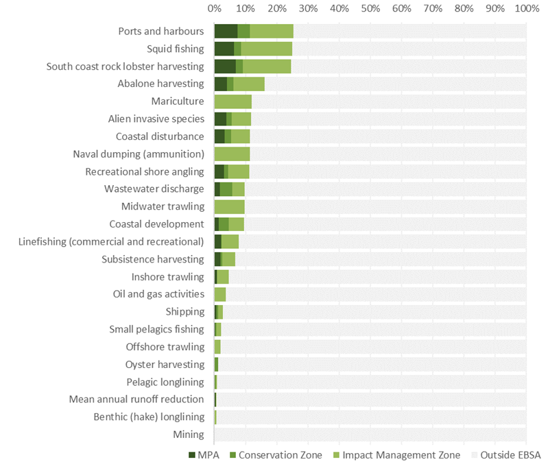
Proposed zonation of the EBSA, with the cumulative intensity footprint of activities within the EBSA (sorted highest to lowest) given relative to the national footprint of those activities to illustrate feasibility of management interventions.
Several of the country’s ports and harbours are located within this EBSA; however, all port infrastructure is within the Impact Management Zone. It is only the East London Port Control area that extends partly into the Conservation Zone. Port and harbour activities should be carefully managed to avoid unacceptable impacts on adjacent Conservation Zones. Particularly, careful management of ports and harbours and mariculture operations are necessary to avoid the introduction of additional alien invasive species. Mariculture in the EBSA is entirely within the Impact Management Zone and comprises a fifth of the national footprint of this activity; it is recommended to continue as a Consent activity, but is recommended to be Prohibited in the Conservation Zone because it does not currently occur within that EBSA zone.
Harvesting south coast rock lobster and abalone within this EBSA are important economic activities that comprises roughly a third to a fifth of the national footprint of those activities, the bulk of which is in the Impact Management Zone. Provision would be made for legal harvesting, with these recommended to be Consent activities. Commercial squid fishing is also an important activity within the EBSA, comprising of a third of the national footprint. It is similarly recommended to be accommodated as a Consent activity. Further, because the south coast rock lobster harvesting, abalone and squid fisheries are selective, these are recommended to continue as Consent activities within the Conservation Zone as well. Less than a fifth of the country’s midwater trawling occurs within the EBSA Impact Management Zone and is recommended to continue as a Consent activity. Other important commercial fisheries include inshore, midwater and offshore trawling, as well as small pelagics fishing and linefishing. Trawling fisheries are recommended to take place in the Impact Management Zone only because they are incompatible with the management objectives of the Conservation Zone, but small pelagics fishing and linefishing (commercial and recreational) are recommended to continue in both EBSA zones as Consent activities. The same is proposed for recreational shore angling and subsistence fishing: both are recommended to be Consent activities in the Conservation and Impact Management Zones.
Dumping of ammunition at sea historically occurred within the EBSA, and these sites fall exclusively within the Impact Management Zone; however, this activity no longer occurs in South Africa. Commercial oil and gas (exploration and production) also occur exclusively in the Impact Management Zone, where it is recommended to be a Consent activity; because it does not currently occur in the Conservation Zone, it is recommended to be Prohibited in that zone. The other activities that fall within this EBSA are very small component of the national footprint, and fall mostly within the Impact Management Zone where the activities could continue with relevant regulations and controls as Consent activities in both EBSA zones. Shipping is recommended to continue in both the Conservation and Impact Management Zones under current general rules and legislation. Thus, in all cases, the EBSA zonation has no or minimal impact on the national footprint of the listed marine activities.
The EBSA is further impacted by a range of other activities, like mean annual runoff reduction, wastewater discharge, coastal development and coastal disturbance, which largely originate from outside the EBSA. These impacts should be managed, but principally fall outside the direct management and zoning of the EBSA. These existing activities are proposed as Consent activities for both EBSA zones, recognising that they should ideally be dealt with in complementary integrated coastal zone management in support of the EBSA. For example, investment in eradicating the alien invasive species could aid in improving the ecological condition of rocky and mixed shores, improving benefits for subsistence and recreational harvesting, and rehabilitation of degraded dunes and formalising access points could support improved habitat for nesting shorebirds, and enhanced benefits for coastal protection during storm surges. Similarly, improved estuary management through development of appropriate freshwater flow requirements and estuarine management plans can improve the ecological condition of the surrounding marine environment, in turn, improving water quality and safe conditions for human recreation and mariculture.
Management recommendations for MPAs
Since the inception of the MARIMSA Project, protection has increased in the EBSA with the declaration of the Addo Elephant National Park and Amathole Offshore MPAs in 2019. This builds on existing protection already afforded by the Sardinia Bay and Amathole MPAs and land-based protected areas in the area. Addo Elephant National Park MPA is also an expansion of the previous Bird Island MPA. It is recommended that existing management is strengthened in the older MPAs, and that full operationalisation of the new MPAs is implemented, including management plans, resourcing, and adequate staffing and law enforcement. Potential MPA expansion within the EBSA should be explored to ensure that the features for which the EBSA was described receive adequate protection. See Future Process below for more details.
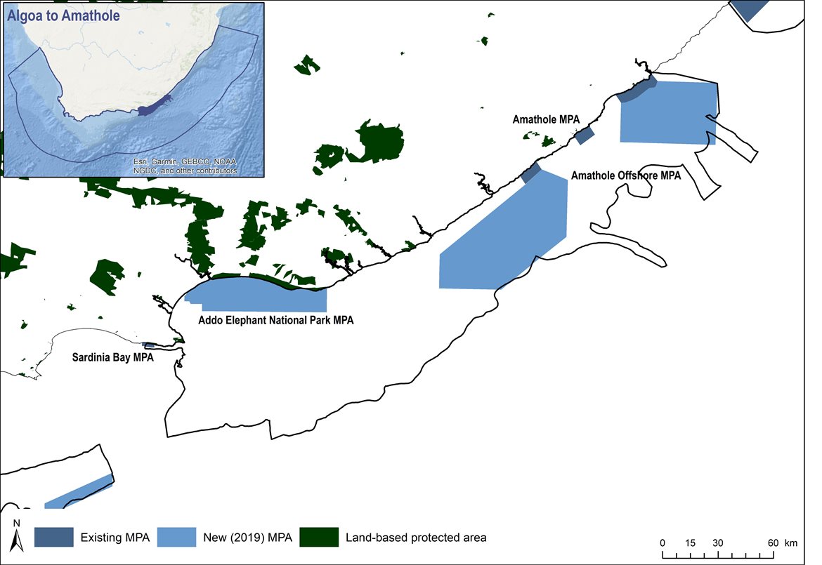
Existing and new marine protected areas (MPAs) in the Algoa to Amathole EBSA. Amathole MPA comprises three parts along the coast, and Amathole Offshore MPA comprises two parts that extend from the northern and southern parts of the Amathole MPA. Land-based protected areas are also shown (from DFFE 2021).
[Top]
Management recommendations for MSP
Developing the biodiversity sector’s input to the national Marine Spatial Planning process
Following the initial management recommendations proposed for Algoa to Amathole, outlined above, South Africa iteratively developed a National Coastal and Marine Spatial Biodiversity Plan (NCMSBP; Harris et al. 2022a,b) that underpinned the Marine Biodiversity Sector Plan (DFFE 2022). The latter constitutes the biodiversity sector’s input into the national Marine Spatial Planning (MSP) process. The NCMSBP comprises a Map of Critical Biodiversity Areas and Ecological Support Areas (abbreviated to CBA Map), and a set of sea-use guidelines that indicate activity compatibility with the management objectives of each of the CBA Map categories. These two components form the basis for the proposed biodiversity zones and management recommendations for the Marine Area Plans. EBSAs are an integral part of the NCMSBP, and thus the Biodiversity Sector Plan. Therefore, these products informed the proposed zoning and sea-use guidelines for EBSAs in the MSP process.
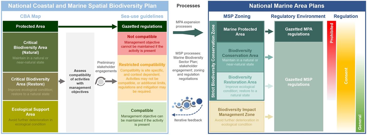
Schematic diagram illustrating that the National Coastal and Marine Spatial Biodiversity Plan will inform the Marine Area Plans through the Marine Biodiversity Sector Plan (DFFE 2022), and will be iteratively updated and refined based on feedback. The process for deriving the sea-use guidelines is also shown, indicating that it is based on an assessment of activity compatibility with the management objective of Critical Biodiversity Area (CBA) Natural, CBA Restore and Ecological Support Areas (ESAs). Marine Protected Area (MPA) expansion, focussing on CBAs, will also take place in a separate but related process. The outcomes of the Marine Spatial Planning and MPA expansion processes will be incorporated into the Marine Area Plans and will be fed back into future updates of the National Coastal and Marine Spatial Biodiversity Plan.
[Top]
Proposed Zones
The proposed biodiversity zones for the EBSA in MSP comprises two types: a Strict Biodiversity Conservation Zone; and a Biodiversity Impact Management Zone. The former has three sub-categories: Marine Protected Area; Biodiversity Conservation Area; and Biodiversity Restoration Area. All of these zones and sub-categories are found in Algoa to Amathole.
There are four MPAs in this EBSA: Sardinia Bay; Addo Elephant National Park MPA; Amathole, and Amathole Offshore. They are managed according to their respective gazetted management regulations. The rest of the Strict Biodiversity Conservation Zone includes a Biodiversity Conservation Area, where the management objective of this zone is to maintain the sites in natural or near-natural ecological condition. There is also a Biodiversity Restoration Area, where the management objective of the zone is to improve the ecological condition of the sites and, in the long term, restore them to a natural / near-natural state, or as near to that state as possible. As a minimum, avoid further deterioration in ecological condition and maintain options for future restoration. The rest of the EBSA is a Biodiversity Impact Management Zone. This is a multi-use area that may already be heavily impacted, but needs to be kept ecologically functional because it is still important for marine biodiversity patterns, ecological processes, and ecosystem services. Therefore, the management objective is to avoid further deterioration in ecological condition.
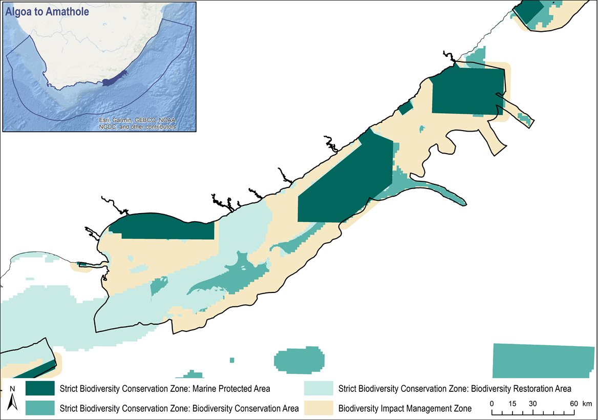
Proposed biodiversity zones for the Algoa to Amathole EBSA for South Africa’s Marine Area Plans.
Proposed Sea-Use Guidelines
All sea-use activities were listed and evaluated according to their compatibility with the management objective of each of the proposed biodiversity zones. Where various aspects of an activity have a different impact on the environment, these were reflected separately, e.g., impacts from petroleum exploration are different to those from production. Activity compatibility was based largely on the ecosystem-pressure matrix from the NBA 2018 (Sink et al. 2019), which is a matrix of expert-based scores of the functional impact and recovery time for each activity on marine ecosystems (adapted from Halpern et al. 2007). Activities were then classified into those that are Compatible, Not Compatible or have Restricted Compatibility with the management objectives of each proposed biodiversity zone. This classification followed a set of predefined principles that account for the severity and extent of impact, similar to the IUCN Red List of Ecosystems criterion C3 (Keith et al. 2013). Some exceptions and adjustments were made based on initial discussions as part of the MSP process.
Sea-use guidelines for Algoa to Amathole. List of all sea-use activities, grouped by their broad sea use and Marine Spatial Planning (MSP) Zones, and categorised according to their compatibility with the management objective of Strict Biodiversity Conservation Zone: Biodiversity Conservation Area (SBCZ: BCA); Strict Biodiversity Conservation Zone: Biodiversity Restoration Area (SBCZ: BRA); and the Biodiversity Impact Management Zone (BIMZ). Activity compatibility is given as Y = yes, compatible, R = restricted compatibility, or N = not compatible. Strict Biodiversity Conservation Zone: Marine Protected Areas (SBCZ: MPA) are managed according to their gazetted regulations.
Proposed management recommendations for activities with each of the different compatibility ratings:
-
Compatible: Activities should be allowed and regulated by current general rules. Notwithstanding, there should still be duty of care, possibly requiring monitoring and evaluation programmes, to avoid unintended cumulative impacts to the biodiversity features for which this area is recognised.
-
Restricted compatibility: A robust site-specific, context-specific assessment is required to determine the activity compatibility depending on the biodiversity features for which the site was selected. Particularly careful attention would need to be paid in areas containing irreplaceable to near-irreplaceable features where the activity may be more appropriately evaluated as not permitted. The ecosystem types in which the activities take place may also be a consideration as to whether or not the activity should be permitted, for example. Where it is permitted to take place, strict regulations and controls over and above the current general rules and legislation would be required to be put in place to avoid unacceptable impacts on biodiversity features. Examples of such regulations and controls include: exclusions of activities in portions of the zone; avoiding intensification or expansion of current impact footprints; additional gear restrictions; and temporal closures of activities during sensitive periods for biodiversity features.
-
Not compatible: The activity should not be permitted to occur in this area because it is not compatible with the management objective. If it is considered to be permitted as part of compromises in MSP negotiations, it would require alternative Strict Biodiversity Conservation Zones and/or offsets to be identified. However, if this is not possible, it is recommended that the activity remains prohibited within the Strict Biodiversity Conservation Zone.
[Top]
Research Needs
There is substantial research and ongoing monitoring within Algoa to Amathole already, especially in Algoa Bay. There are no specific research needs for this EBSA in addition to those for all EBSAs.
Future Process
There needs to be full operationalisation and practical implementation of the Addo Elephant National Park MPA and the Amathole Offshore MPA, including management plans, staffing, and resources. There also needs to be full operationalisation and practical implementation of the proposed zoning in the national marine spatial plan, with gazetted management regulations following the proposed management recommendations outlined above. Possible MPA expansion within the EBSA should be explored, with relevant areas included into focus areas that can be considered further in a dedicated MPA expansion process with adequate and meaningful stakeholder engagement. In particular, there needs to be enhanced spatial management measures in the canyons offshore of Gqeberha (Port Elizabeth). Further alignment between land-based and marine biodiversity priorities should also be strengthened, e.g., through the cross-realm planning in the CoastWise project. This EBSA is also part of a World Heritage Site proposal that is being developed.
References
DFFE, 2021. South African Protected Areas Database (SAPAD). Available at: https://egis.environment.gov.za/protected_and_conservation_areas_database.
DFFE, 2022. Biodiversity Sector Plan: Input for Marine Spatial Planning (MSP). Department of Forestry, Fisheries and the Environment, Cape Town.
Halpern, B.S., Selkoe, K.A., Micheli, F., Kappel, C.V., 2007. Evaluating and Ranking the Vulnerability of Global Marine Ecosystems to Anthropogenic Threats. Conservation Biology 21, 1301–1315.
Harris, L.R., Holness, S.D., Kirkman, S.P., Sink, K.J., Majiedt, P., Driver, A., 2022. National Coastal and Marine Spatial Biodiversity Plan Version 1.2 (Released: 12-04-2022). Nelson Mandela University, Department of Forestry, Fisheries and the Environment, and South African National Biodiversity Institute, South Africa.
Harris, L.R., Holness, S.D., Kirkman, S.P., Sink, K.J., Majiedt, P., Driver, A., in review. A robust, systematic approach for developing the biodiversity sector’s input for multi-sector Marine Spatial Planning. Ocean & Coastal Management.
Keith, D.A., Rodríguez, J.P., Rodríguez-Clark, K.M., Nicholson, E., Aapala, K., Alonso, A., Asmussen, M., Bachman, S., Basset, A., Barrow, E.G., Benson, J.S., Bishop, M.J., Bonifacio, R., Brooks, T.M., Burgman, M.A., Comer, P., Comín, F.A., Essl, F., Faber-Langendoen, D., Fairweather, P.G., Holdaway, R.J., Jennings, M., Kingsford, R.T., Lester, R.E., Nally, R.M., McCarthy, M.A., Moat, J., Oliveira-Miranda, M.A., Pisanu, P., Poulin, B., Regan, T.J., Riecken, U., Spalding, M.D., Zambrano-Martínez, S., 2013. Scientific Foundations for an IUCN Red List of Ecosystems. PLoS ONE 8, e62111.
Sink, K.J., Holness, S., Skowno, A.L., Franken, M., Majiedt, P.A., Atkinson, L.J., Bernard, A., Dunga, L.V., Harris, L.R., Kirkman, S.P., Oosthuizen, A., Porter, S., Smit, K., Shannon, L., 2019. Chapter 7: Ecosystem Threat Status, In South African National Biodiversity Assessment 2018 Technical Report Volume 4: Marine Realm. eds K.J. Sink, M.G. van der Bank, P.A. Majiedt, L.R. Harris, L.J. Atkinson, S.P. Kirkman, N. Karenyi. South African National Biodiversity Institute, Pretoria. http://hdl.handle.net/20.500.12143/6372.
[Top]