EBSA Status Assessment and Management Recommendations
Ecological Condition, Threat Status, Current Protection and Key Features in the EBSA
Relevant Pressures and Activities (impact, extent) | Management Interventions Needed for the EBSA
Activity Evaluation Per Zone: Zoning Feasibility | Research Needs & Future Process
Back to the Namibian EBSA status and management home page
Cape Fria is highly productive because of an intense upwelling cell at the northern boundary of the Benguela Current. This makes it a key foraging ground for many top predators. It is also critical for aggregations of almost the entire global population of the endemic Damara Tern during specific periods of the year, and is a breeding site for Cape fur seals. Its remote location means that it is relatively undisturbed and in a natural state.
Click here for the full EBSA description
[Top]
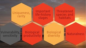
Cape Fria has multiple ecological features and ecosystem types that need to be protected for the area to maintain the characteristics that give it its EBSA status. The criteria for which this EBSA ranks highly are: importance for life-history stages; importance for threatened species and habitats; biological productivity, and naturalness. There are 17 ecosystems types represented, including two Endangered types: the Central Namib Outer Shelf and Cunene Outer Shelf. The upwelling cell also marks the northern boundary of the Benguela Current, thus falling within the biogeographic transition zone, with a relatively high local biodiversity because communities comprise species at both the northern and southern limits of their distributions. The area is critical for aggregations of almost the entire global population of Damara Tern during specific periods of the year; is an important breeding site for Cape fur seals; and is an important foraging area for both species. Given its remote location, the coast is in relatively pristine condition, but may be threatened by industrial development in the future.
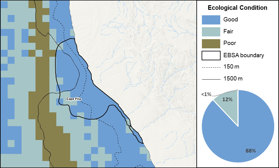
Cape Fria proportion of area in each ecological condition category.
The Cape Fria EBSA is in good (88%) to fair (12%) ecological condition, with <1% in poor ecological condition. Consequently, 14 of the 17 ecosystem types in the area are Least Concern, comprising 67% of the EBSA extent. Three ecosystem types are threatened, including two Endangered types (Central Namib Outer Shelf and Cunene Outer Shelf) comprising 33% and the EBSA, and one Vulnerable type (Cunene Shelf Edge) that makes up <1% of the EBSA.
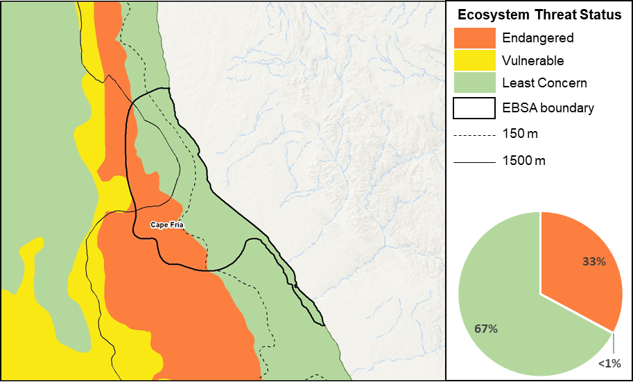
Cape Fria proportion of area in each ecosystem threat status category.
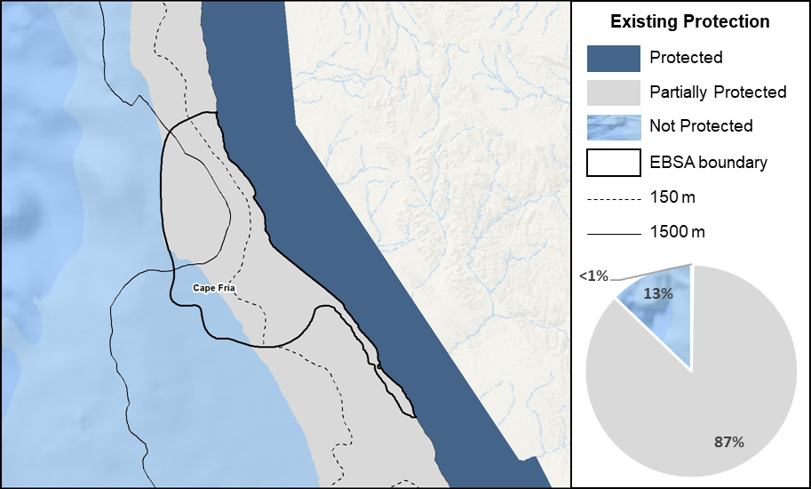
Cape Fria proportion of area in a Marine Protected Area (MPA).
There are no MPAs in the area, however, Cape Fria and surrounds is a remote coastal area adjacent to the Skeleton Coast National Park, which affords <1% protected to some of the seashore ecosystem types. Most of the EBSA (87%) is partially protected through inshore trawl restrictions. Nevertheless, only one ecosystem type (Cunene Shelf Edge) is Not Protected, the rest are either Moderately Protected (7 types) or Well Protected (9 types).
Threat status, protection level and ecological condition of ecosystem types in the EBSA. Other key features are also listed.
|
Feature
|
Threat Status
|
Protection Level
|
Condition (%)
|
|
Good
|
Fair
|
Poor
|
|
Ecosystem Types
|
|
Central Namib Inner Shelf
|
LC
|
MP
|
100.00
|
0.00
|
0.00
|
|
Central Namib Outer Shelf
|
EN
|
MP
|
81.59
|
18.41
|
0.00
|
|
Cunene Exposed Rocky Shore
|
LC
|
MP
|
100.00
|
0.00
|
0.00
|
|
Cunene Inner Shelf
|
LC
|
MP
|
96.77
|
3.23
|
0.00
|
|
Cunene Inshore
|
LC
|
MP
|
100.00
|
0.00
|
0.00
|
|
Cunene Intermediate Sandy Beach
|
LC
|
WP
|
100.00
|
0.00
|
0.00
|
|
Cunene Mixed Shore
|
LC
|
WP
|
100.00
|
0.00
|
0.00
|
|
Cunene Outer Shelf
|
EN
|
MP
|
68.32
|
31.32
|
0.36
|
|
Cunene Reflective Sandy Beach
|
LC
|
WP
|
100.00
|
0.00
|
0.00
|
|
Cunene Shelf Edge
|
VU
|
NP
|
8.89
|
91.11
|
0.00
|
|
Hoanib Dissipative Sandy Beach
|
LC
|
WP
|
96.30
|
3.70
|
0.00
|
|
Hoanib Dissipative-Intermediate Sandy Beach
|
LC
|
WP
|
53.04
|
46.96
|
0.00
|
|
Hoanib Exposed Rocky Shore
|
LC
|
WP
|
95.75
|
4.25
|
0.00
|
|
Hoanib Inshore
|
LC
|
MP
|
88.51
|
11.49
|
0.00
|
|
Hoanib Intermediate Sandy Beach
|
LC
|
WP
|
96.00
|
4.00
|
0.00
|
|
Hoanib Mixed Shore
|
LC
|
WP
|
91.28
|
8.72
|
0.00
|
|
Hoanib Sheltered Rocky Shore
|
LC
|
WP
|
0.00
|
100.00
|
0.00
|
|
Other Features
|
-
Damara Terns
-
Cape fur seals
-
Diverse and abundant assemblages of fish
-
Upwelling cell
|
[Top]
-
There are five major pressures present in the EBSA, with the highest cumulative pressure in the southern coastal portion of the EBSA, and offshore on the shelf edge.
-
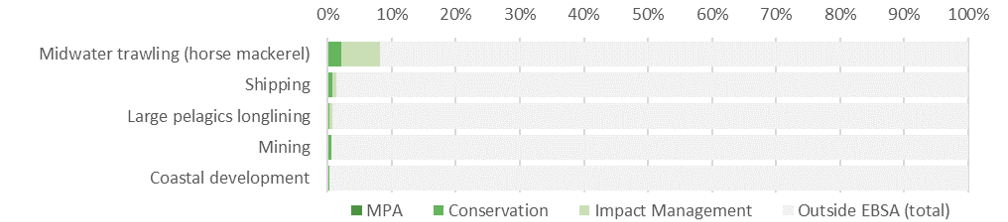
Key pressures that most directly impact the features for which the EBSA is described include: midwater trawling (horse mackerel), shipping, large pelagic longlining, coastal development and mining. The former three activities contribute most to the pressure profile of the EBSA, most of which activity is in the Impact Management Zone. Note that small pelagics fishing used to be a key pressure in this area, but is no longer an active industry in Namibia.
-
Note also that this assessment of pressures is based on existing data. Where new, finer scale data have since become available, these are presented below (e.g., for shipping and combined fisheries) to enable more accurate recommendations for management of activities. Also, there are some emerging activities and activities for which no spatial data are available that are not included here, but are considered in the management recommendations for the EBSA, based on expert and industry information.
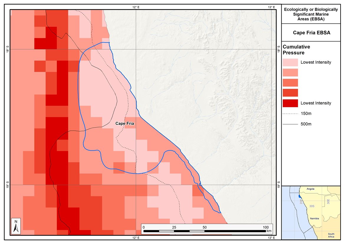
Map of cumulative pressure from all activities in the EBSA and surrounds. Darker reds indicate higher pressure intensity.
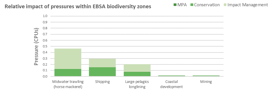
Pressure (in arbitrary cumulative pressure units, CPUs) summed for each pressure in the EBSA, per proposed EBSA biodiversity zone, ranked left (highest) to right (lowest) by the overall relative importance of pressures in this EBSA.
[Top]
Improved place-based protection of EBSA features should be pursued. In support of this, the EBSA is divided into a Conservation Zone and an Impact Management Zone, both comprising several areas within the EBSA. The aim of the Conservation Zone is to secure core areas of key biodiversity features in natural / near-natural ecological condition. Strict place-based biodiversity conservation is thus directed at securing key biodiversity features in a natural or semi-natural state, or as near to this state as possible. Activities or uses that have significant biodiversity impacts should be prohibited. Where possible and appropriate these areas should be considered for formal protection e.g., Marine Protected Areas or other effective area-based conservation measures (OECM). The aim of the Impact Management Zone is to manage negative impacts on key biodiversity features where strict place-based measures are not practical or not essential. In this zone, the focus is management of impacts on key biodiversity features in a mixed-use area, with the objective to keep biodiversity features in at least a functional state. Activities or uses which have significant biodiversity impacts should be strictly controlled and/or regulated. Within this zone, there should be no increase in the intensity of use or the extent of the footprint of activities that have significant biodiversity impacts. Where possible, biodiversity impacts should be reduced. As far as possible, the Conservation Zone was designed deliberately to avoid conflicts with existing activities. Note that there are no marine protected areas in this EBSA; however, it borders the terrestrial Skeleton National Park, and there is partial protection of the coastal marine environment conferred through inshore trawl restrictions.
Proposed zonation of the EBSA into Conservation (medium green) and Impact Management (light green) Zones. MPAs are overlaid in orange outlines, with the extent within the EBSA given in dark green. Click on each of the zones to view the proposed management recommendations.
[Top]
Protection of features in the rest of the Conservation Zone may require additional Marine Protected Area declaration/expansion. Other effective conservation measures should also be applied via Marine Spatial Planning to ensure that the existing activities/uses are appropriately controlled to ensure compatibility of activities with the environmental requirements for achieving the management objectives of the EBSA Conservation and Impact Management Zones. Further, no new pressures should be extended into the Conservation Zone, even if they currently occur in the Impact Management Zone of the EBSA.
Recommended compatibility (consent1 or prohibited2) of activities currently present in the EBSA3 in the Conservation and Impact Management Zones
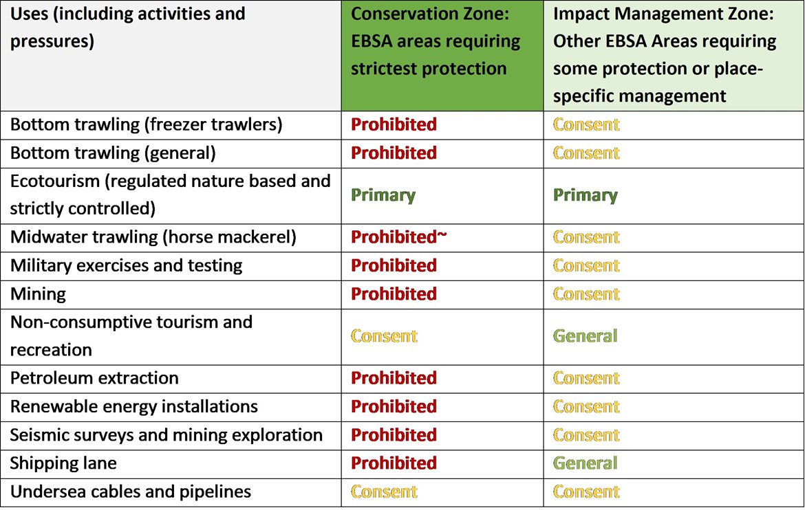
2Prohibited: An activity which is not allowed or should not be allowed because it is incompatible with maintaining the biodiversity objectives of the zone.1Consent: An activity which can continue in this zone subject to specific regulation and control.
~Activity Prohibited but present in zone; need to confirm whether this needs to be kept, changed to Consent, or zone boundary changed.
3Note that activities present in Namibia that are not relevant to the EBSA have been excluded from the table (e.g., the harvested species does not occur in the area; or the industry operates at a depth outside the depth range of the EBSA).
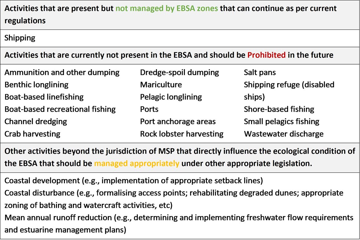
Furthermore, no new activities that can negatively impact the environment should be allowed in the EBSA, and some activities present in the EBSA do not need to be managed by EBSA zoning and can continue as per the current regulations. There are also some pressures on biodiversity features within the EBSA that originate from activities outside of these EBSA or beyond the jurisdiction of MSP. In support of maintaining the ecological integrity of and benefits delivered by the key biodiversity features, these other activities need to be appropriately managed by complementary initiatives.
Recommendations for other activities outside the EBSA or the MSP management jurisdiction.
Activity Evaluation Per Zone: Zoning Feasibility
Proposed zonation of the EBSA, with the cumulative intensity footprint of activities within the EBSA (sorted highest to lowest) given relative to the national footprint of those activities to illustrate feasibility of management interventions.
All activities have <10% of their national footprint within the EBSA, the greatest of which is for midwater trawling (horse mackerel). This is a non-destructive fishery and is recommended to continue as a Consent activity in the Impact Management Zone, however, it is recommended to be Prohibited in the Conservation Zone. The other activities have a much smaller proportion of their national footprint in the EBSA (<1.5%). Pelagic longlining is also a non-destructive fishery, but has high bycatch; it is therefore recommended to continue in the Impact Management Zone, but to be Prohibited in the Conservation Zone. Mining is currently active in the Conservation Zone. This may be as a result of poor data resolution and the exact footprint needs confirmation because this activity is not compatible with the management objectives of the Conservation Zone, and is thus recommended to be Prohibited. Shipping is recommended to continue under current general rules and legislation. Other activities noted in the table of management recommendations above are either not currently present in the EBSA or are emerging activities; as far as possible, these are accommodated in the EBSA, depending on their compatibility with the management objectives of the two zones. Thus, the EBSA zonation has no or minimal impact on the national footprint for the listed marine activities.
There are also several activities that are largely outside the EBSA but have downstream impacts to the biodiversity within the EBSA, e.g., from mean annual runoff reduction, coastal development, coastal disturbance, and wastewater discharge. The impacts should be managed, but principally fall outside the direct management and zoning of the EBSA. These existing activities should ideally be dealt with in complementary integrated coastal zone management in support of the EBSA. For example, rehabilitation of degraded dunes and formalising access points could support improved habitat for nesting shorebirds, and enhanced benefits for coastal protection during storm surges. Similarly, improved estuary management through development of appropriate freshwater flow requirements, estuarine management plans and wastewater management regulations can improve the ecological condition of the surrounding marine environment, in turn, improving water quality and safe conditions for human recreation in support of the proposed expansion of ecotourism. It is also recommended to consider developing and implementing Biodiversity Management Plans for the iconic/top predator species, e.g., seals and Damara Terns, in support of securing the biodiversity features for which the EBSA is recognised, where these are not already in place.
Research Needs
There is fairly limited research that has been conducted in the area. Consequently, there are many gaps to fill in terms of understanding the biodiversity patterns and ecological processes within this EBSA area (including the phenomenon of the Damara tern aggregations). Further, without having better information on the local species present, there is currently no information from which the vulnerability of the site can be ranked. Knowing the current vulnerability will be key to determining which pressures the site is likely able to withstand. These gaps can all be filled as part of addressing the general research needs.
Future Process
Proposed zoning needs to be included in the northern MSP when undertaken.
References
UNEP-WCMC, IUCN, 2022. Protected Planet: The World Database on Protected Areas (WDPA) and World Database on Other Effective Area-based Conservation Measures (WD-OECM) [Online], September 2022. UNEP-WCMC and IUCN, Cambridge, UK. Available at: www.protectedplanet.net.
[Top]