EBSA Status Assessment and Management Recommendations
Ecological Condition, Threat Status, Current Protection and Key Features in the EBSA
Relevant Pressures and Activities (impact, extent) | Management Interventions Needed for the EBSA
Activity Evaluation Per Zone: Zoning Feasibility | Research Needs & Future Process
Back to the Namibian EBSA status and management home page
Namib Flyway is a highly productive area in the Benguela system that attracts large numbers of sea- and shorebirds, marine mammals, sea turtles and other fauna, many of which species are threatened. It also includes several Important Bird and Biodiversity Areas, and Ramsar sites, highlighting its importance for life history stages. It includes rare bays and lagoons on the Namibian coast.
Click here for the full EBSA description
[Top]
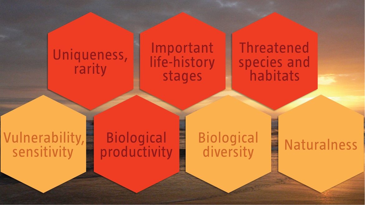
Namib Flyway has many features and ecosystem types that need to be protected for the area to maintain the characteristics that give it its EBSA status. The criteria for which this EBSA ranks highly are: uniqueness and rarity; importance for life-history stages; importance for threatened species and habitats; and biological productivity. There are 10 ecosystem types represented, mostly including a variety of shore types (as well as lagoons), three of which are Endangered. The main coastal features are two sheltered bays (Walvis Bay and Sandwich Harbour), another north-facing but less sheltered bay (Conception Bay), three lagoons (Cape Cross Lagoons, Swakop River Mouth Lagoon, and Walvis Bay Lagoon), one cape (Cape Cross) and one man-made shallow water habitat (Mile 4 salt works). The sheltered bays and shallow waters lead to warmer waters and higher productivity. There is a weak upwelling cell off Walvis Bay, which adds to the productivity. It supports resident, Palearctic, Oceanic and intra-African migrant bird species, as well as several cetaceans, turtles, seals and fish.
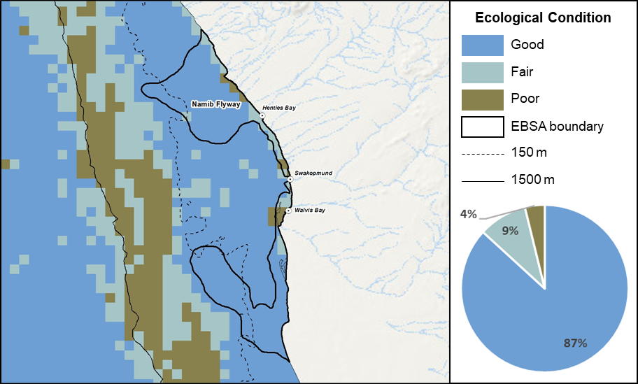
Namib Flyway proportion of area in each ecological condition category.
Namib Flyway is mostly in good ecological condition (87%), with most of the remaining area being in fair (9%) or poor (4%) ecological condition. Consequently, the bulk of the extent comprises seven ecosystem types that are Least Concern (78% of the EBSA extent), with a much smaller portion comprising three Endangered ecosystem types (22% of the EBSA extent) that is mostly deeper than 150 m. The Endangered ecosystem types include the Central Namib Outer Shelf, Kuiseb Lagoon Coast and Kuiseb Mixed Shore.
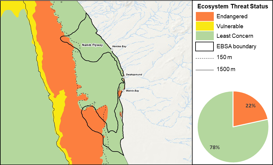
Namib Flyway proportion of area in each ecosystem threat status category.
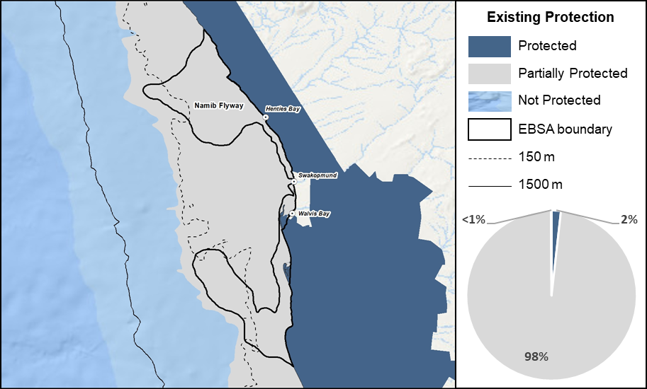
Namib Flyway proportion of area in a Marine Protected Area (MPA).
Despite the central sections of the EBSA being highly utilized for the major Walvis Bay port, almost the full extent of the EBSA falls within a Partial Protection area because it is within the shallow water trawling exclusion area. Some important coastal sites are Protected by the adjacent National Parks, especially Sandwich Harbour and Cape Cross, as well as portions of the Walvis Bay lagoon and Pelican Point wetlands adjacent to Walvis Bay. This comprises 2% of the EBSA extent.
Threat status, protection level and ecological condition of ecosystem types in the EBSA. Other key features are also listed.
|
Feature
|
Threat Status
|
Protection Level
|
Condition (%)
|
|
Good
|
Fair
|
Poor
|
|
Ecosystem Types
|
|
Central Namib Inner Shelf
|
LC
|
MP
|
97.19
|
2.68
|
0.13
|
|
Central Namib Outer Shelf
|
EN
|
MP
|
100.00
|
0.00
|
0.00
|
|
Kuiseb Dissipative-Intermediate Sandy Beach
|
LC
|
WP
|
34.77
|
35.99
|
29.23
|
|
Kuiseb Exposed Rocky Shore
|
LC
|
WP
|
0.00
|
0.00
|
100.00
|
|
Kuiseb Inshore
|
LC
|
WP
|
36.06
|
46.59
|
17.35
|
|
Kuiseb Intermediate Sandy Beach
|
LC
|
WP
|
17.26
|
64.74
|
18.01
|
|
Kuiseb Lagoon Coast
|
EN
|
WP
|
28.35
|
10.62
|
61.03
|
|
Kuiseb Mixed Shore
|
EN
|
WP
|
0.00
|
52.44
|
47.56
|
|
Kuiseb Reflective Sandy Beach
|
LC
|
WP
|
33.92
|
54.35
|
11.73
|
|
Kuiseb Sandy Beach Sandy Beach
|
LC
|
WP
|
100.00
|
0.00
|
0.00
|
|
Other Features
|
|
· Numerous Palearctic, Oceanic and intra-African migrant bird species
· Turtles
· Cetaceans
· Seals
|
[Top]
-
There are 11 pressures present in this EBSA, of small pelagics fishing has the highest cumulative pressure profile.
-
Key pressures in this EBSA that most directly impact the features for which the EBSA is described include: small pelagics fishing, linefishing, mariculture and coastal development. These activities will need to be managed particularly well in order to protect the biodiversity features and processes for which this EBSA is recognised, particularly in terms of support the large aggregations of birds.
-
Activities in Namibia that are not present in this EBSA include: monkfish fishing, hake commercial trawling, crab and lobster harvesting, oil and gas activities, and tuna pole fishing.
-
Note that this assessment of pressures is based on existing data. Where new, finer scale data have since become available, these are presented below (e.g., for shipping and combined fisheries) to enable more accurate recommendations for management of activities. Also, there are some emerging activities and activities for which no spatial data are available that are not included here, but are considered in the management recommendations for the EBSA, based on expert and industry information.
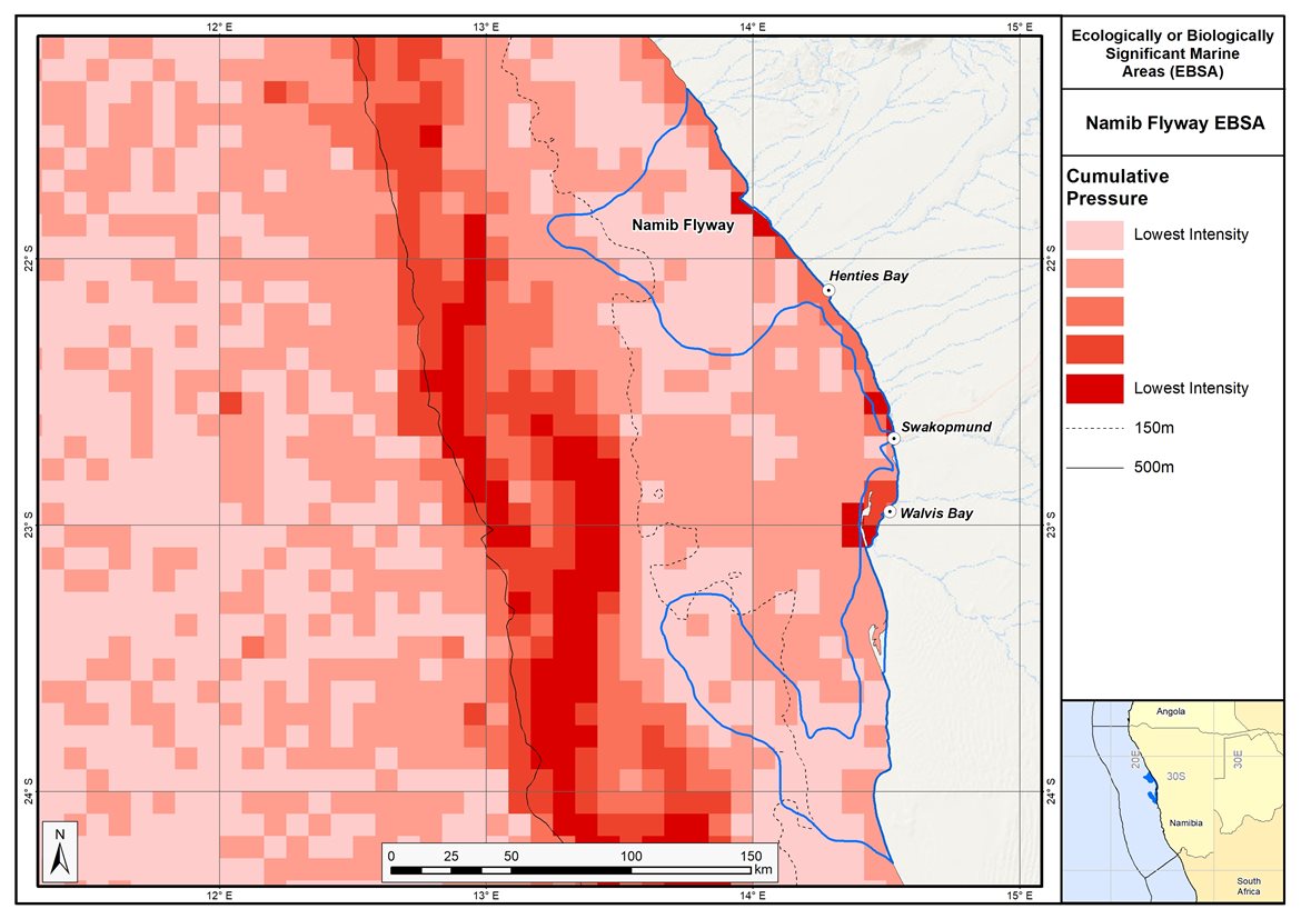
Map of cumulative pressure from all activities in the EBSA and surrounds. Darker reds indicate higher pressure intensity.
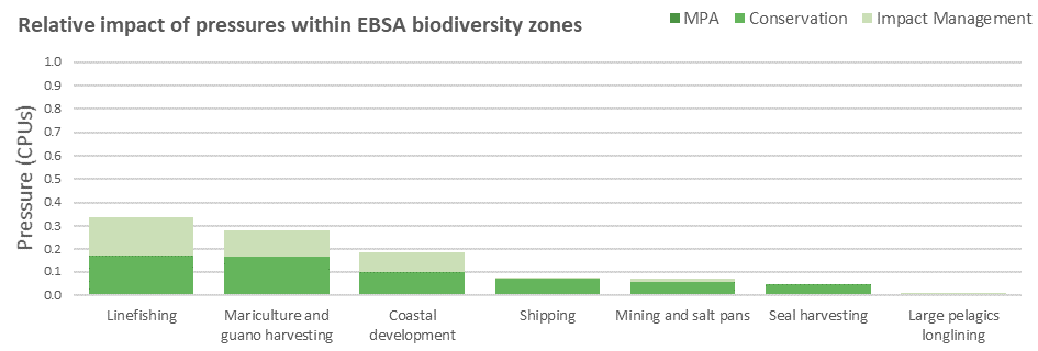
Pressure (in arbitrary cumulative pressure units, CPUs) summed for each pressure in the EBSA, per proposed EBSA biodiversity zone, ranked left (highest) to right (lowest) by the overall relative importance of pressures in this EBSA.
[Top]
Improved place-based protection of EBSA features should be pursued. In support of this, the EBSA is divided into a Conservation Zone and an Impact Management Zone, both comprising several areas within the EBSA. The aim of the Conservation Zone is to secure core areas of key biodiversity features in natural / near-natural ecological condition. Strict place-based biodiversity conservation is thus directed at securing key biodiversity features in a natural or semi-natural state, or as near to this state as possible. Activities or uses that have significant biodiversity impacts should be prohibited. Where possible and appropriate these areas should be considered for formal protection e.g., Marine Protected Areas or other effective area-based conservation measures (OECM). The aim of the Impact Management Zone is to manage negative impacts on key biodiversity features where strict place-based measures are not practical or not essential. In this zone, the focus is management of impacts on key biodiversity features in a mixed-use area, with the objective to keep biodiversity features in at least a functional state. Activities or uses which have significant biodiversity impacts should be strictly controlled and/or regulated. Within this zone, there should be no increase in the intensity of use or the extent of the footprint of activities that have significant biodiversity impacts. Where possible, biodiversity impacts should be reduced. As far as possible, the Conservation Zone was designed deliberately to avoid conflicts with existing activities. Note that there are no marine protected areas in this EBSA; however, it borders the terrestrial Namib-Naukluft National Park and Dorob National Park, and there is partial protection of the coastal marine environment conferred through inshore trawl restrictions.
Proposed zonation of the EBSA into Conservation (medium green) and Impact Management (light green) Zones. MPAs are overlaid in orange outlines, with the extent within the EBSA given in dark green. Click on each of the zones to view the proposed management recommendations.
[Top]
Protection of features in the rest of the Conservation Zone may require additional Marine Protected Area declaration/expansion. Other effective conservation measures should also be applied via Marine Spatial Planning to ensure that the existing activities/uses are appropriately controlled to ensure compatibility of activities with the environmental requirements for achieving the management objectives of the EBSA Conservation and Impact Management Zones. Further, no new pressures should be extended into the Conservation Zone, even if they currently occur in the Impact Management Zone of the EBSA.
Recommended compatibility (consent1 or prohibited2) of activities currently present in the EBSA3 in the Conservation and Impact Management Zones
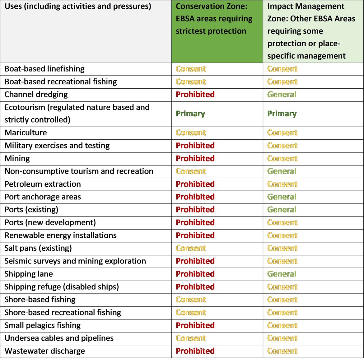
1Consent: An activity which can continue in this zone subject to specific regulation and control.
2Prohibited: An activity which is not allowed or should not be allowed because it is incompatible with maintaining the biodiversity objectives of the zone.
3Note that activities present in Namibia that are not relevant to the EBSA have been excluded from the table (e.g., the harvested species does not occur in the area; or the industry operates at a depth outside the depth range of the EBSA).
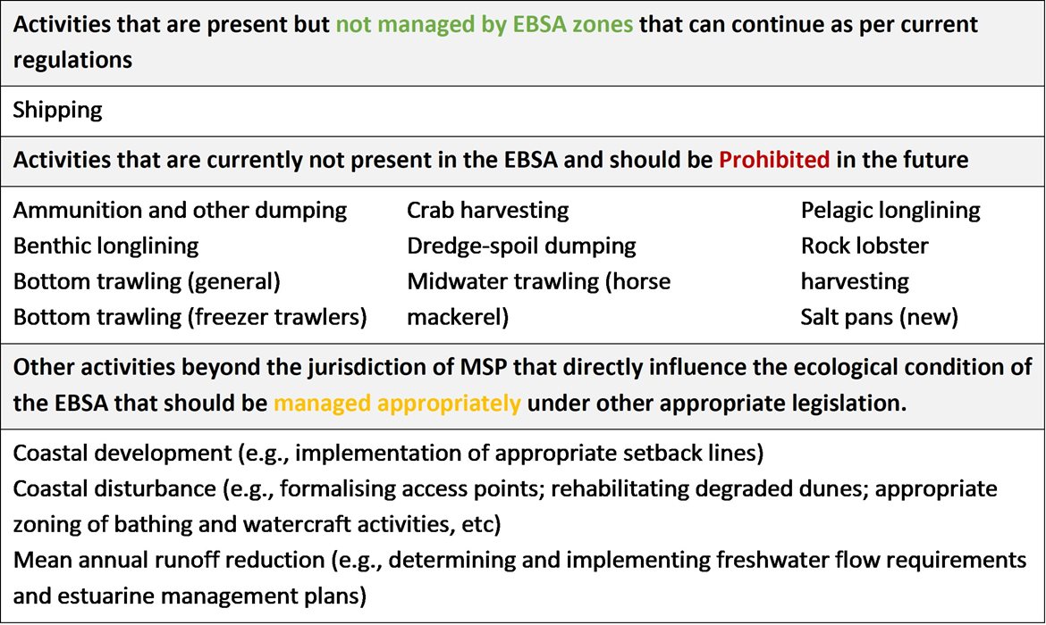
Furthermore, no new activities that can negatively impact the environment should be allowed in the EBSA, and some activities present in the EBSA do not need to be managed by EBSA zoning and can continue as per the current regulations. There are also some pressures on biodiversity features within the EBSA that originate from activities outside of these EBSA or beyond the jurisdiction of MSP. In support of maintaining the ecological integrity of and benefits delivered by the key biodiversity features, these other activities need to be appropriately managed by complementary initiatives.
Recommendations for other activities outside the EBSA or the MSP management jurisdiction.
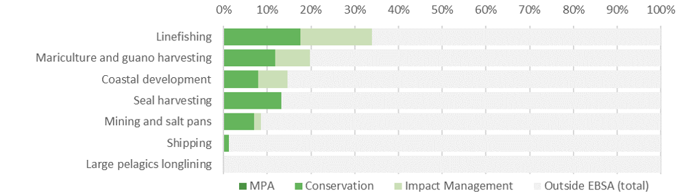
Proposed zonation of the EBSA, with the cumulative intensity footprint of activities within the EBSA (sorted highest to lowest) given relative to the national footprint of those activities to illustrate feasibility of management interventions.
A third of the country’s linefishing takes place within this EBSA, split approximately equally between the Conservation and Impact Management Zones. Recognising the value of this industry, and the notable extent to which it occurs in the EBSA, it is recommended to continue as a Consent activity in both zones. Also, a fifth of the national mariculture and guano harvesting occurs within the EBSA. These activities are also permitted to continue subject to regulations and controls as a Consent activity in both EBSA zones. Only a fraction of the national pelagic longlining footprint is present in the EBSA, and thus it is recommended to be Prohibited in both zones. Shipping can continue in both the Conservation and Impact Management Zones under current general rules and legislation, however, there might need to be some control and regulation for shipping lanes in the Conservation Zone, where it is recommended to be a Consent activity. Other activities noted in the table of management recommendations above are either not currently present in the EBSA or are emerging activities; as far as possible, these are accommodated in the EBSA, depending on their compatibility with the management objectives of the two zones. Thus, the EBSA zonation has no or minimal impact on the national footprint for the listed marine activities.
There are also several activities that are largely outside the EBSA but have downstream impacts to the biodiversity within the EBSA, e.g., from mean annual runoff reduction, coastal development, coastal disturbance, and wastewater discharge. The impacts should be managed, but principally fall outside the direct management and zoning of the EBSA. These existing activities are proposed as Consent activities for both EBSA zones, recognising that they should ideally be dealt with in complementary integrated coastal zone management in support of the EBSA. For example, investment in eradicating the alien invasive species could aid in improving the ecological condition of rocky and mixed shores, improving benefits for subsistence and recreational harvesting; and rehabilitation of degraded dunes and formalising access points could support improved habitat for nesting shorebirds, and enhanced benefits for coastal protection during storm surges. Similarly, improved estuary management through development of appropriate freshwater flow requirements, estuarine management plans and wastewater management regulations can improve the ecological condition of the surrounding marine environment, in turn, improving water quality and safe conditions for human recreation.
Research Needs
In addition to the general research needs, the increase of industrial activities in the area, particularly expansion of the port and anticipated flurry of hydrocarbon exploration and mining, warrants particular research focus on the myriad of threatened species that rely on the high productivity of this EBSA. Notably, knowledge of the presence and distribution of cetacean species is largely lacking, and yet these marine mammals are known to be affected by seismic surveys during hydrocarbon exploration. Similarly, the increased risk of marine vessels and animal collisions (as traffic through the expanded port increases) is also an issue for species like leatherback turtles, particularly because the Western Indian Ocean population (that partly use this EBSA as a foraging site) is listed as Critically Endangered. Knowing when and where these animals are in the EBSA will enable better spatial and temporal management of conflicting activities.
Future Process
The Namib Flyway is within the Central Namibian Marine Spatial Planning Core Area, which is the first Marine Area Plan being developed in Namibia. There needs to be full operationalisation and practical implementation of the proposed zoning in this Marine Area Plan, with gazetted management regulations following the proposed management recommendations outlined above. Possible MPA expansion within the EBSA should be explored, with relevant areas included into focus areas that can be considered further in a dedicated MPA expansion process with adequate and meaningful stakeholder engagement.
References
UNEP-WCMC, IUCN, 2022. Protected Planet: The World Database on Protected Areas (WDPA) and World Database on Other Effective Area-based Conservation Measures (WD-OECM) [Online], September 2022. UNEP-WCMC and IUCN, Cambridge, UK. Available at: www.protectedplanet.net.
Ministry of Fisheries and Marine Resources, 2022. The Central Marine Spatial Plan of Namibia. Windhoek: Namibia.
[Top]