EBSA Status Assessment and Management Recommendations
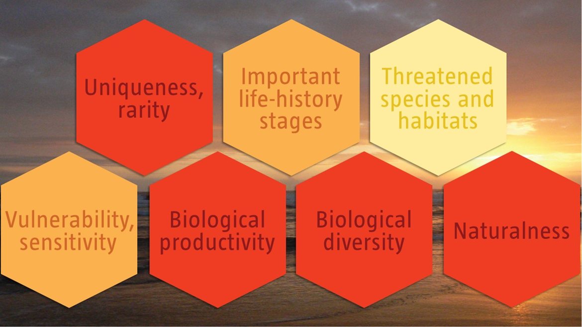
Ecological Condition, Threat Status, Current Protection and Key Features in the EBSA
Relevant Pressures and Activities (impact, extent) | Management Interventions Needed for the EBSA
Activity Evaluation Per Zone: Zoning Feasibility | Research Needs & Future Process
Back to the Angolan EBSA status and management home page
Bentiaba includes 24 different ecosystem types, ranging from intertidal to abyssal types, and includes key, rare features such as seamounts and canyons. As a result, diversity is very rich. Offshore diversity is less well known, but coastal areas support turtles, birds and cetaceans. Coastal upwelling drives high productivity. The EBSA is exposed to very few pressures so the area is mostly natural and in good ecological condition.
Click here for the full EBSA description
[Top]
Bentiaba has many features and ecosystem types that need to be protected for the area to maintain the characteristics that give it its EBSA status. The criteria for which this EBSA ranks highly are: uniqueness and rarity; biological productivity; biological diversity; and naturalness. There are 24 ecosystem types represented, one of which is an Endangered rocky shore ecocystem type; the other 23 ecosystem types are Least Concern. Most ecosystem types are Not Protected, four are Poorly Protected and only one is Moderately Protected. The morphology of the seabed suggests that the underlying geology comprises sandy, muddy and rocky substrates, contributing to the rich diversity in the EBSA, which is higher than in the surrounding areas and includes iconic species such as turtles, cetaceans and birds. In the southern portion, the continental shelf drops steeply, such that there are very deep areas near to the coast. This contributes to a key influence of coastal upwelling in driving high productivity in the area. The proposed area is currently subjected to very few pressures, and thus most of the site is in a highly natural condition.
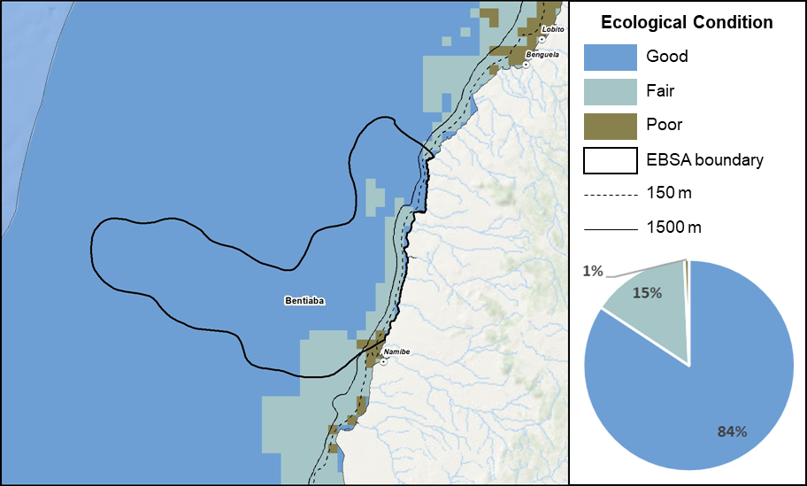
Bentiaba proportion of area in each ecological condition category.
Bentiaba is largely in good ecological condition (84%), with smaller proportions in fair (15%) and poor (1%) ecological condition. As a result, all ecosystem types represented in the EBSA are Least Concern, except for one Endangered ecosystem type: Namibe Exposed Rocky Shore. There are no MPAs in the area, so the whole EBSA is currently not protected.
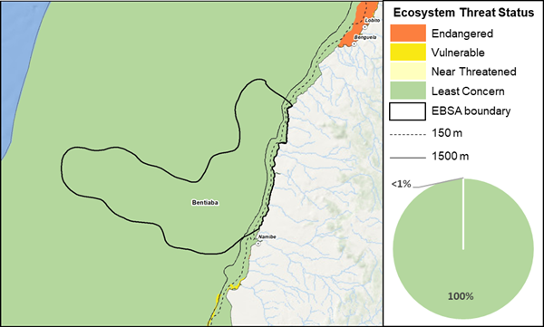
Bentiaba proportion of area in each ecosystem threat status category.
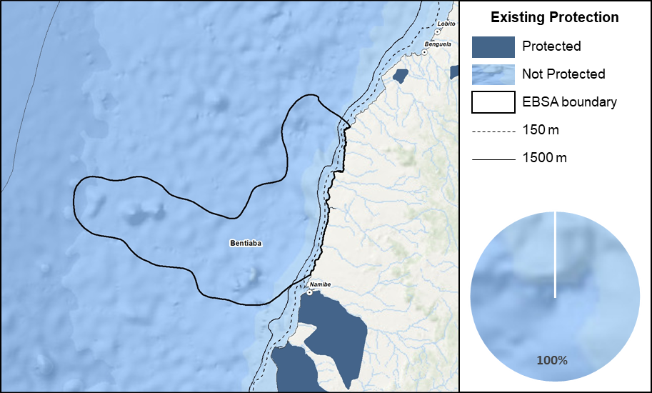
Bentiaba proportion of area in a Marine Protected Area (MPA).
Threat status, protection level and ecological condition of ecosystem types in the EBSA. Other key features are also listed.
|
Feature
|
Threat Status
|
Protection Level
|
Condition (%)
|
|
Good
|
Fair
|
Poor
|
|
Ecosystem Types
|
|
Benguela Boulder Beach Rocky Shore
|
LC
|
NP
|
100.00
|
0.00
|
0.00
|
|
Benguela Estuarine Shore
|
LC
|
NP
|
100.00
|
0.00
|
0.00
|
|
Benguela Exposed Rocky Shore
|
LC
|
NP
|
100.00
|
0.00
|
0.00
|
|
Benguela Inshore
|
LC
|
NP
|
100.00
|
0.00
|
0.00
|
|
Benguela Intermediate Sandy Beach
|
LC
|
NP
|
100.00
|
0.00
|
0.00
|
|
Benguela Island
|
LC
|
NP
|
60.29
|
39.71
|
0.00
|
|
Benguela Mixed Shore
|
LC
|
NP
|
96.76
|
3.24
|
0.00
|
|
Benguela Reflective Sandy Beach
|
LC
|
NP
|
94.30
|
5.70
|
0.00
|
|
Benguela Sheltered Rocky Shore
|
LC
|
NP
|
97.59
|
2.41
|
0.00
|
|
Cunene Abyss
|
LC
|
NP
|
100.00
|
0.00
|
0.00
|
|
Namibe Boulder Beach Rocky Shore
|
LC
|
NP
|
74.98
|
25.02
|
0.00
|
|
Namibe Dissipative-Intermediate Sandy Beach
|
LC
|
NP
|
100.00
|
0.00
|
0.00
|
|
Namibe Estuarine Shore
|
LC
|
NP
|
49.40
|
50.60
|
0.00
|
|
Namibe Exposed Rocky Shore
|
EN
|
PP
|
36.41
|
10.66
|
52.94
|
|
Namibe Inshore
|
LC
|
NP
|
56.09
|
41.76
|
2.15
|
|
Namibe Intermediate Sandy Beach
|
LC
|
PP
|
79.30
|
20.70
|
0.00
|
|
Namibe Lower Slope
|
LC
|
NP
|
93.08
|
6.92
|
0.00
|
|
Namibe Mixed Shore
|
LC
|
PP
|
90.12
|
9.69
|
0.18
|
|
Namibe Reflective Sandy Beach
|
LC
|
MP
|
83.35
|
16.65
|
0.00
|
|
Namibe Seamount
|
LC
|
NP
|
86.05
|
13.95
|
0.00
|
|
Namibe Shelf
|
LC
|
NP
|
23.26
|
73.11
|
3.63
|
|
Namibe Shelf Edge
|
LC
|
NP
|
19.45
|
70.98
|
9.57
|
|
Namibe Sheltered Rocky Shore
|
LC
|
PP
|
58.38
|
39.22
|
2.39
|
|
Namibe Upper Slope
|
LC
|
NP
|
55.77
|
42.03
|
2.20
|
|
Other Features
|
-
Turtles
-
Cetaceans
-
Birds
-
Areas of upwelling
|
[Top]
-
There are seven key pressures present in this EBSA, of which benthic longlining and shipping cover the full extent of the EBSA. Benthic longlining also has the highest pressure profile in the EBSA.
-
Activities that are present in the EBSA include: benthic longlining, artisanal fishing, trawling, shipping, small pelagics fishing, coastal development and mining, with activity and impacts concentrated on the continental shelf. These activities will need to be managed particularly well in order to protect the fragile benthic biodiversity and top predators/iconic species for which this EBSA is recognised.
-
Activities that occur in Angola but are not present in the EBSA include: pelagic longlining and oil and gas activities.
-
Note that the data of individual pressures used in the assessment were from global datasets, some of which were mapped at a coarser resolution than is displayed below (i.e., shipping and commercial fishing). The finer scale data are included to facilitate more accurate management recommendations. Notwithstanding, details on fishery distributions will need to be confirmed with the various industries because it may affect their respective management recommendations.
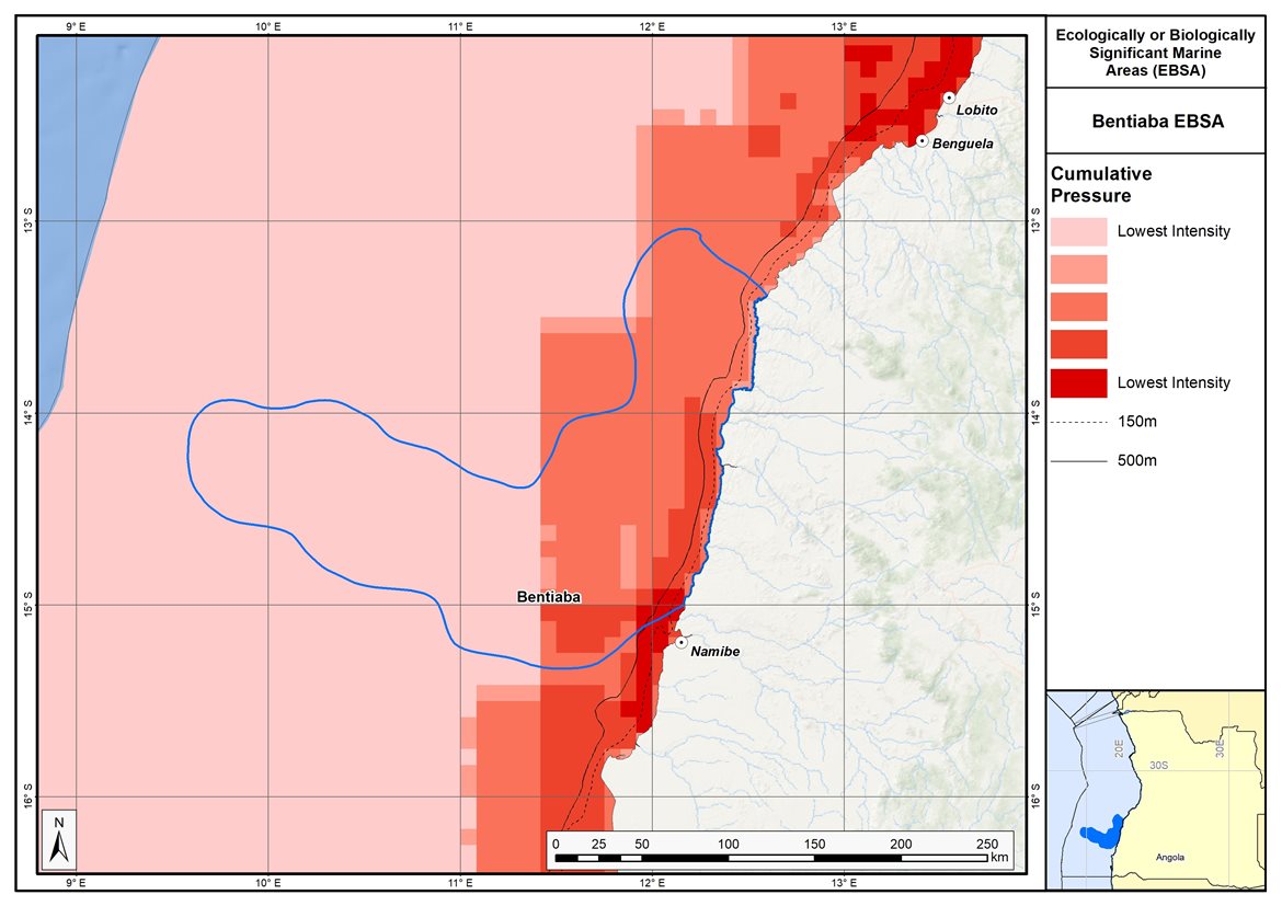
Map of cumulative pressure from all activities in the EBSA and surrounds. Darker reds indicate higher pressure intensity.
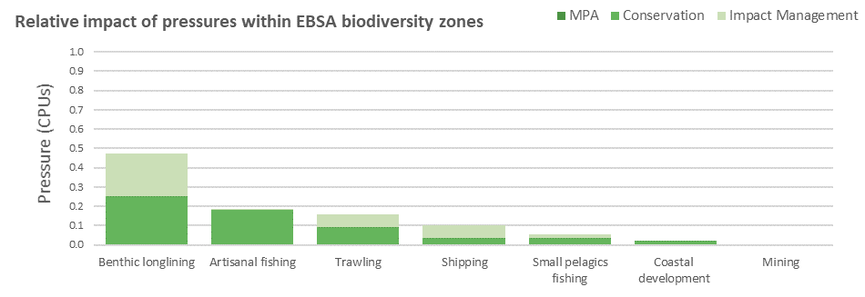
Pressure (in arbitrary cumulative pressure units, CPUs) summed for each pressure in the EBSA, per proposed EBSA biodiversity zone, ranked left (highest) to right (lowest) by the overall relative importance of pressures in this EBSA.
[Top]
Improved place-based protection of EBSA features should be pursued. In support of this, the EBSA is divided into a Conservation Zone and an Impact Management Zone, both comprising several areas within the EBSA. The aim of the Conservation Zone is to secure core areas of key biodiversity features in natural / near-natural ecological condition. Strict place-based biodiversity conservation is thus directed at securing key biodiversity features in a natural or semi-natural state, or as near to this state as possible. Activities or uses that have significant biodiversity impacts should be prohibited. Where possible and appropriate these areas should be considered for formal protection e.g., Marine Protected Areas or other effective area-based conservation measures (OECM). The aim of the Impact Management Zone is to manage negative impacts on key biodiversity features where strict place-based measures are not practical or not essential. In this zone, the focus is management of impacts on key biodiversity features in a mixed-use area, with the objective to keep biodiversity features in at least a functional state. Activities or uses which have significant biodiversity impacts should be strictly controlled and/or regulated. Within this zone, there should be no increase in the intensity of use or the extent of the footprint of activities that have significant biodiversity impacts. Where possible, biodiversity impacts should be reduced. As far as possible, the Conservation Zone was designed deliberately to avoid conflicts with existing activities. Note that there are no marine protected areas in this EBSA.
Proposed zonation of the EBSA into Conservation (medium green) and Impact Management (light green) Zones. MPAs are overlaid in orange outlines, with the extent within the EBSA given in dark green. Click on each of the zones to view the proposed management recommendations.
[Top]
Protection of features in the rest of the Conservation Zone may require additional Marine Protected Area declaration/expansion. Other effective conservation measures should also be applied via Marine Spatial Planning to ensure that the existing activities/uses are appropriately controlled to ensure compatibility of activities with the environmental requirements for achieving the management objectives of the EBSA Conservation and Impact Management Zones. Further, no new pressures should be extended into the Conservation Zone, even if they currently occur in the Impact Management Zone of the EBSA.
Recommended compatibility (consent1 or prohibited2) of activities currently present in the EBSA3 in the Conservation and Impact Management Zones
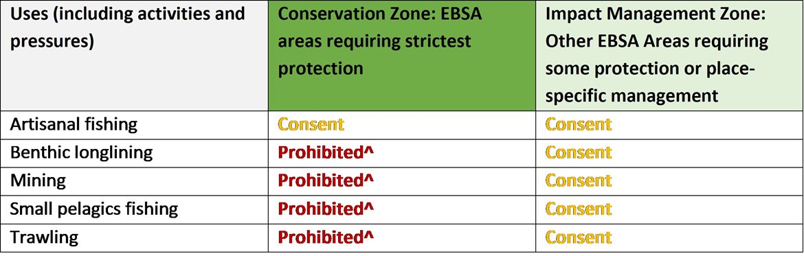
2Prohibited: An activity which is not allowed or should not be allowed because it is incompatible with maintaining the biodiversity objectives of the zone.1Consent: An activity which can continue in this zone subject to specific regulation and control.
^Need to check whether activity is legitimately present in the Conservation Zone or if it is artificially present because of the coarse data resolution; if legitimately present, Consent or revise zone to exclude activity in some cases; if no, Prohibited.
3Note that activities present in Angola that are not relevant to the EBSA have been excluded from the table (e.g., the harvested species does not occur in the area; or the industry operates at a depth outside the depth range of the EBSA).
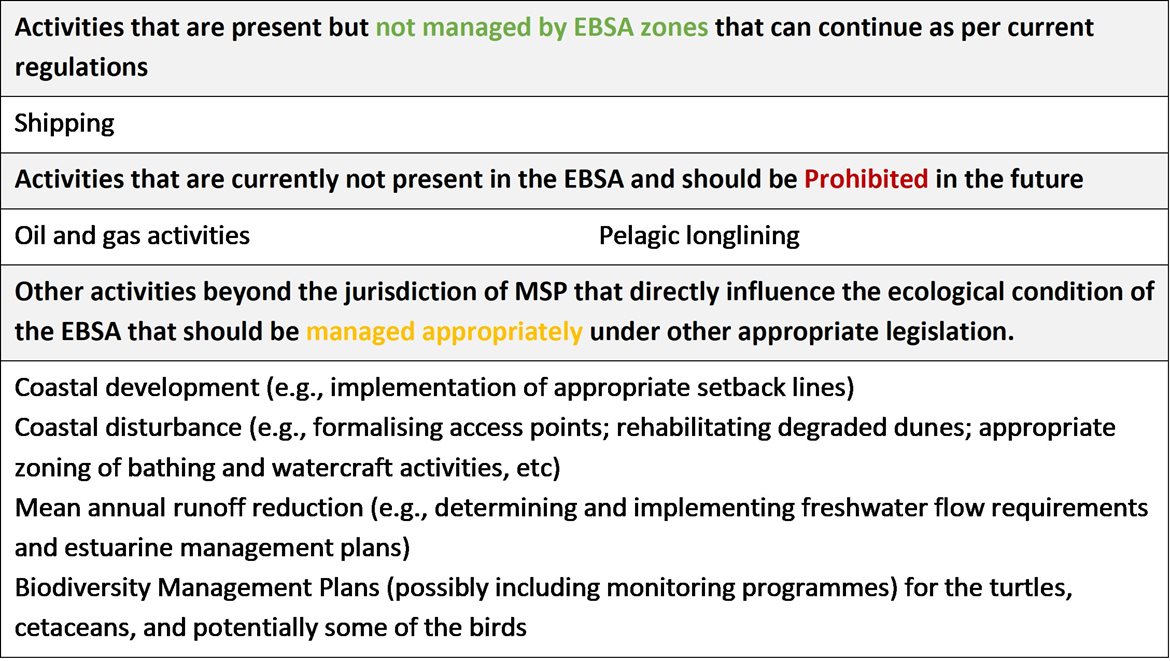
Furthermore, no new activities that can negatively impact the environment should be allowed in the EBSA, and some activities present in the EBSA do not need to be managed by EBSA zoning and can continue as per the current regulations. There are also some pressures on biodiversity features within the EBSA that originate from activities outside of these EBSA or beyond the jurisdiction of MSP. In support of maintaining the ecological integrity of and benefits delivered by the key biodiversity features, these other activities need to be appropriately managed by complementary initiatives. Note that there are no marine protected areas in this EBSA.
Recommendations for other activities outside the EBSA or the MSP management jurisdiction.
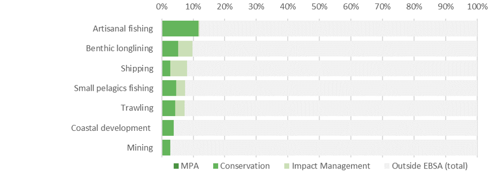
Proposed zonation of the EBSA, with the cumulative intensity footprint of activities within the EBSA (sorted highest to lowest) given relative to the national footprint of those activities to illustrate feasibility of management interventions.
Acknowledging the contribution of artisanal fishing to coastal households in the area surrounding the EBSA, this activity is accommodated in the EBSA zonation and is recommended to continue in both EBSA zones as a Consent activity. Confirmation is required from the fishing and mining industries as to which activities are in fact present in which EBSA zones. In principle, the non-destructive fishing practices (benthic longlining and small pelagics fishing) are recommended to be Consent activities in the zones where they are currently present, and Prohibited in the zones where they are not currently present. For destructive fishing, i.e., trawling, this activity is not compatible with the management objectives of the EBSA Conservation Zone and it is recommended to be Prohibited. If it is currently present in the Conservation Zone, it is recommended that the zone boundary be modified to accommodate the activity in the Impact Management Zone, where it is recommended to be a Consent activity. Mining is also a destructive activity, and is similarly recommended to be Prohibited in the Conservation Zone and permitted as a Consent activity in the Impact Management Zone if it currently is present in that zone. Shipping is recommended to continue under current general rules and legislation. For all activities, except artisanal fishing, the proportion of the activity footprint within the EBSA is less than 10% of the national footprint, and the EBSA zonation has no or minimal impact on the footprint for the listed marine activities.
There are also several activities that are largely outside the EBSA but have downstream impacts to the biodiversity within the EBSA, e.g., from mean annual runoff reduction, coastal development, coastal disturbance, and wastewater discharge. The impacts should be managed, but principally fall outside the direct management and zoning of the EBSA. These existing activities are proposed as Consent activities for both EBSA zones, recognising that they should ideally be dealt with in complementary integrated coastal zone management in support of the EBSA. For example, it is recommended that no further coastal development is constructed within the Conservation Zone, and constructed conservatively in the Impact Management Zone. Further, rehabilitation of degraded dunes and formalising access points could support improved habitat for nesting shorebirds, and enhanced benefits for coastal protection during storm surges. Similarly, improved estuary management through development of appropriate freshwater flow requirements, estuarine management plans and wastewater management regulations can improve the ecological condition of the surrounding marine environment, in turn, improving water quality and safe conditions for human recreation. It is also recommended to consider developing and implementing Biodiversity Management Plans for the iconic/top predator species, e.g., turtles, cetaceans and some of the seabirds and shorebirds in support of securing the biodiversity features for which the EBSA is recognised.
Research Needs
Of the general research needs, improved foundational biodiversity information is especially highlighted here because it is currently very limited for this site. Future research and biodiversity surveys are highly recommended.
Future Process
Angola’s preliminary national Marine Spatial Plan (Republic of Angola, 2022), which incorporates the outcomes of the pilot central area (Republic of Angola et al., 2019), was approved in February 2023. This effectively formalizes the EBSA conservation and impact management zones as the national biodiversity zones for the MSP. However, futher work and engagement is still required to clarify the details of the allowed uses of the zones, which will then require implementation, monitoring and management.
The Conservation areas of the EBSA are being taken forward as the core of an emerging national MPA network. A technical proposal has been prepared to support this, which has been through government review and revision, but the stakeholder processes have not yet begun. The key steps that need to be taken for this EBSA include:
-
Initiating the required stakeholder process
-
Negotiations around final MPA boundaries
-
Refining zones and their specific sea uses and regulations
-
Formal gazetting as an MPA
-
Resourcing MPA management, management plans, and staffing
-
Monitoring and evaluating the outcomes
References
Republic of Angola, 2022. Preliminary Proposal of the Marine Spatial Planning Plan in Angola: National Plan. Ministry of Fisheries and Sea, National Directorate for the Affairs of the Sea. Luanda, Angola.
Republic of Angola, 2019. Preliminary Proposal of the Marine Spatial Planning Plan in Angola: Palmeirinhas Pilot Area - Foz do Rio Tapado. Ministry of Fisheries and Sea, National Directorate for the Affairs of the Sea. Luanda, Angola.
[Top]