EBSA Status Assessment and Management Recommendations
Ecological Condition, Threat Status, Current Protection and Key Features in the EBSA
Relevant Pressures and Activities (impact, extent) | Management Interventions Needed for the EBSA
Activity Evaluation Per Zone: Zoning Feasibility | Research Needs & Future Process
Back to the Angolan EBSA status and management home page
Namibe is a transboundary area of elevated productivity resulting from the outflow of the Kunene River into the ocean, a lagoon at the river mouth, seamounts, canyons, and the Tigres island-bay complex – all unique or rare features. It comprises a highly diverse collection of species and habitats in very close proximity, many of which are also threatened. The EBSA also supports key life-history stages of many species.
Click here for the full EBSA description
[Top]
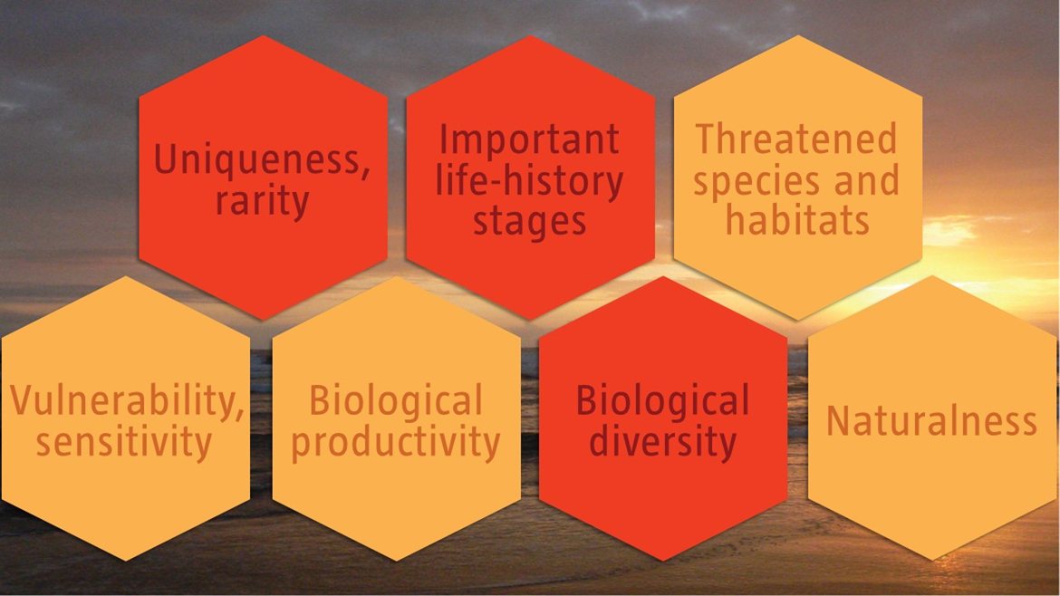
Namibe is a transboundary EBSA between Angola and Namibia that has a myriad of features and ecosystem types that need to be protected for the area to maintain the characteristics that give it its EBSA status. The criteria for which this EBSA ranks highly are: uniqueness and rarity; importance for life-history stages; biological productivity; and biological diversity. There are nine different ecosystems represented which includes various shore and shelf types, and the EBSA includes key features such as the Kunene River mouth and associated lagoon, the Tigres Island-Bay complex, seamounts and canyons. Namibe comprises a highly diverse collection of species and habitats in very close proximity, many of which are also threatened, with unique and other features that promote high productivity. In turn this drives importance of the area for supporting the life-histories of key species, such as providing foraging, breeding and resting habitats for seals, fish, turtles, and migratory and resident birds.
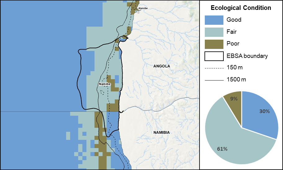
Namibe proportion of area in each ecological condition category.
Namibe is in good (30%) to fair (61%) ecological condition, with only 9% considered to be in poor ecological condition. Seven of the nine ecosystem types represented are Least Concern, which comprise 89% of the EBSA extent. There are two threatened ecosystem types: the Endangered Cunene Outer Shelf and Vulnerable Cunene Shelf Edge that respectively comprise 6% and 5% of the EBSA. These are located on the outer shelf to shelf edge between -150 m and -1500 m, mainly in the south. Five ecosystem types are Well Protected, three are Moderately Protected, and one is Not Protected.
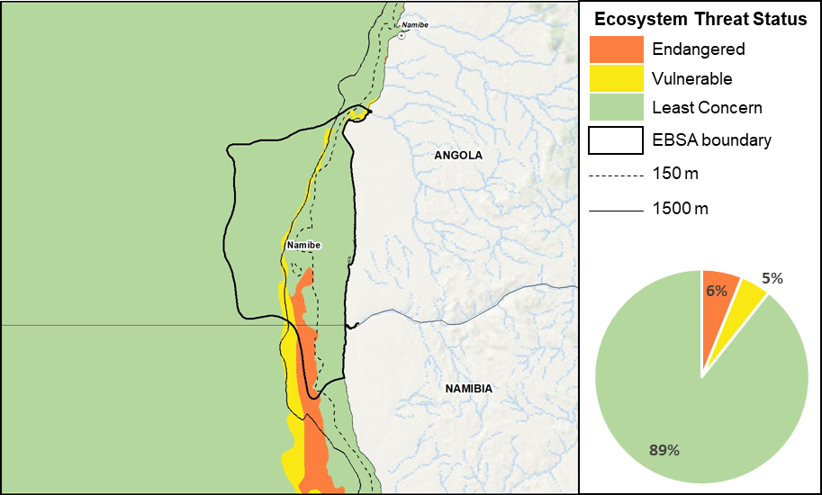
Namibe proportion of area in each ecosystem threat status category.
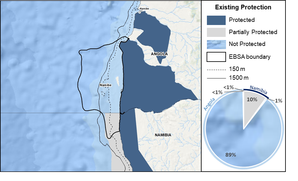
Namibe proportion of area in a Marine Protected Area (MPA).
There are no MPAs in the area; however, the entire EBSA extent is contiguous with terrestrial reserves in both countries: Iona National Park in Angola, and Skeleton Coast National Park in Namibia. The majority of the EBSA is not protected (89%), but there are is partial protection through inshore trawl restrictions in the Namibian section of the EBSA (10% of the EBSA extent).
Threat status, protection level and ecological condition of ecosystem types in the EBSA. Other key features are also listed.
|
Feature
|
Threat Status
|
Protection Level
|
Condition (%)
|
|
Good
|
Fair
|
Poor
|
|
Ecosystem Types
|
|
Cunene Dissipative-Intermediate Sandy Beach
|
LC
|
WP
|
100.00
|
0.00
|
0.00
|
|
Cunene Estuarine Shore
|
LC
|
WP
|
100.00
|
0.00
|
0.00
|
|
Cunene Inner Shelf
|
LC
|
MP
|
99.82
|
0.18
|
0.00
|
|
Cunene Inshore
|
LC
|
MP
|
100.00
|
0.00
|
0.00
|
|
Cunene Intermediate Sandy Beach
|
LC
|
WP
|
100.00
|
0.00
|
0.00
|
|
Cunene Mixed Shore
|
LC
|
WP
|
100.00
|
0.00
|
0.00
|
|
Cunene Outer Shelf
|
EN
|
MP
|
47.10
|
46.29
|
6.60
|
|
Cunene Reflective Sandy Beach
|
LC
|
WP
|
100.00
|
0.00
|
0.00
|
|
Cunene Shelf Edge
|
VU
|
NP
|
0.00
|
0.00
|
100.00
|
|
Other Features
|
-
Coastal wetlands associated with the Tigres Island-Bay complex
-
Numerous bird species
-
Lagoon associated with the Kunene River mouth
-
Cape fur seals
-
Turtles
-
Cetaceans
-
Fish spawning areas
-
Kunene Upwelling Cell
|
The proposed zonation and recommended management in transboundary EBSAs is split at the national borders, with each country responsible for EBSA management in their own jurisdiction only. The sections below present the proposed management of Angola's portion of this EBSA.
[Top]
-
There are 12 pressures present in this EBSA, of which shipping is the only one that covers the entire EBSA extent.
-
Of these 12 pressures, seven are present in the Angolan portion of the EBSA, including: benthic longlining, trawling, shipping, small pelagics fishing, coastal development, artisanal fishing and mining, with the highest cumulative pressure intensity just north of the Kunene River mouth. The footprint of these activities is largely in the Impact Management Zone. Benthic longlining and trawling have the highest pressure profile in the EBSA.
-
These seven activities will need to be managed particularly well in order to protect the estuarine habitat for associated birds, and offshore ecosystem types, nursery habitats, and fish assemblages for which this EBSA is recognised. Given the critical role of the estuary in Namibe, activities upstream of the estuary will also need to be managed, e.g., to limit impacts of flow reduction caused by damming and abstraction, but this is beyond the scope of EBSA management and MSP.
-
Activities that take place in Angola but are not present in the EBSA include: pelagic longlining, oil and gas activities.
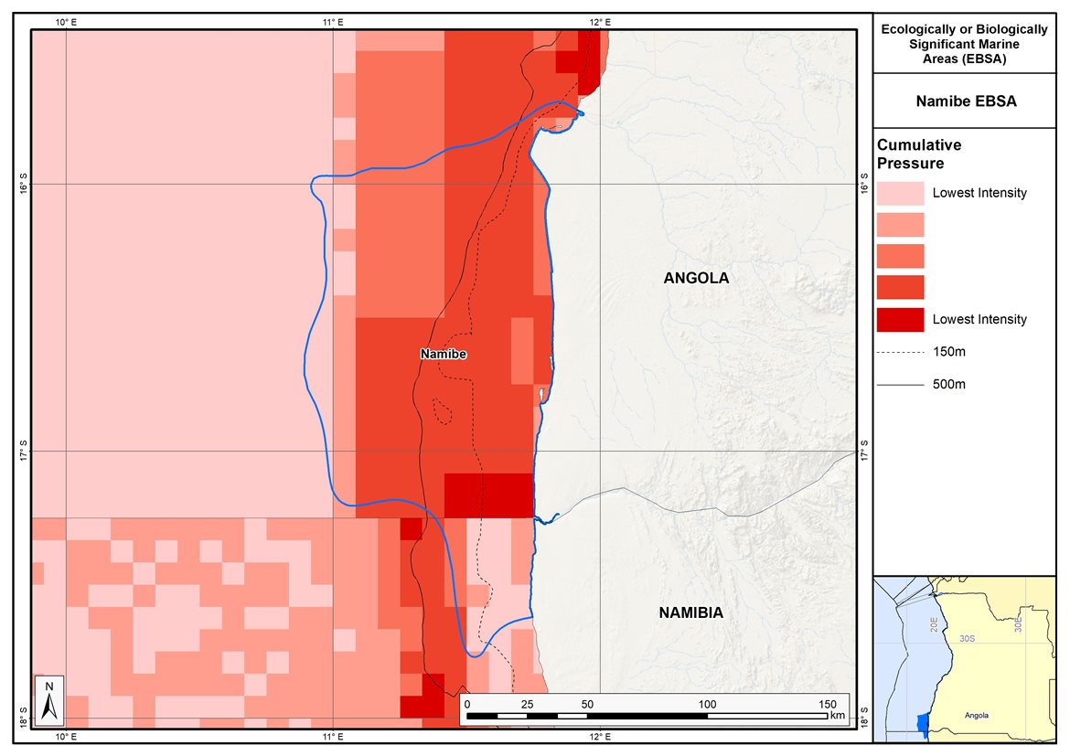
Map of cumulative pressure from all activities in the EBSA and surrounds. Darker reds indicate higher pressure intensity.
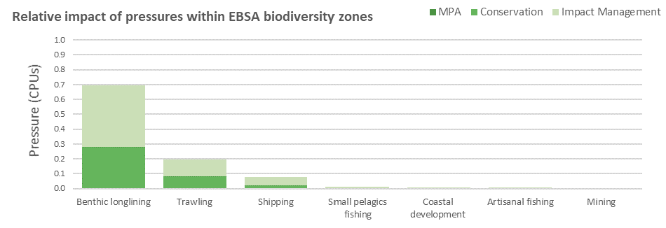
Pressure (in arbitrary cumulative pressure units, CPUs) summed for each pressure in the EBSA, per proposed EBSA biodiversity zone, ranked left (highest) to right (lowest) by the overall relative importance of pressures in this EBSA. Note that pressures from coastal development to mining each comprise <1% of the EBSA pressure profile.
[Top]
Improved place-based protection of EBSA features should be pursued. In support of this, the EBSA is divided into a Conservation Zone and an Impact Management Zone, both comprising several areas within the EBSA. The aim of the Conservation Zone is to secure core areas of key biodiversity features in natural / near-natural ecological condition. Strict place-based biodiversity conservation is thus directed at securing key biodiversity features in a natural or semi-natural state, or as near to this state as possible. Activities or uses that have significant biodiversity impacts should be prohibited. Where possible and appropriate these areas should be considered for formal protection e.g., Marine Protected Areas or other effective area-based conservation measures (OECM). The aim of the Impact Management Zone is to manage negative impacts on key biodiversity features where strict place-based measures are not practical or not essential. In this zone, the focus is management of impacts on key biodiversity features in a mixed-use area, with the objective to keep biodiversity features in at least a functional state. Activities or uses which have significant biodiversity impacts should be strictly controlled and/or regulated. Within this zone, there should be no increase in the intensity of use or the extent of the footprint of activities that have significant biodiversity impacts. Where possible, biodiversity impacts should be reduced. As far as possible, the Conservation Zone was designed deliberately to avoid conflicts with existing activities.
Proposed zonation of the EBSA into Conservation (medium green) and Impact Management (light green) Zones. MPAs are overlaid in orange outlines, with the extent within the EBSA given in dark green. Click on each of the zones to view the proposed management recommendations.
[Top]
Protection of features in the Conservation Zone may require additional Marine Protected Area declaration/expansion. Other effective conservation measures should also be applied via Marine Spatial Planning to ensure that the existing activities/uses are appropriately controlled to ensure compatibility of activities with the environmental requirements for achieving the management objectives of the EBSA Conservation and Impact Management Zones. Further, no new pressures should be extended into the Conservation Zone, even if they currently occur in the Impact Management Zone of the EBSA.
Recommended compatibility (consent1 or prohibited2) of activities currently present in the EBSA3 in the Conservation and Impact Management Zones
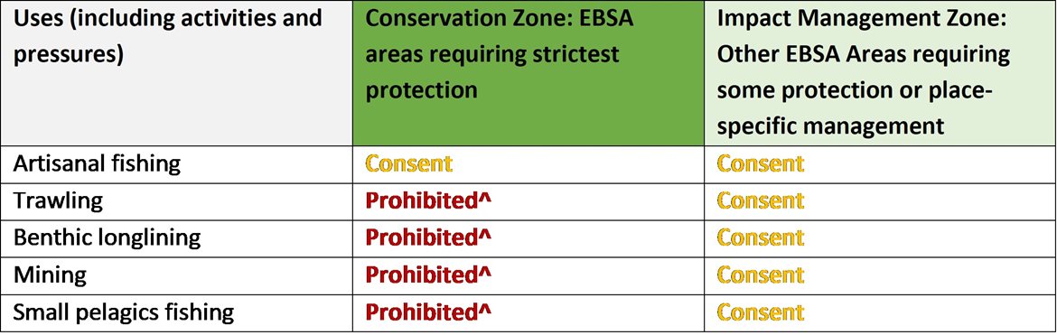
2Prohibited: An activity which is not allowed or should not be allowed because it is incompatible with maintaining the biodiversity objectives of the zone.1Consent: An activity which can continue in this zone subject to specific regulation and control.
*Not present in zone.
^Need to check whether activity is legitimately present in the Conservation Zone or if it is artificially present because of the coarse data resolution; if legitimately present, Consent or revise zone to exclude activity in some cases; if no, Prohibited.
3Note that activities present in Angola that are not relevant to the EBSA have been excluded from the table (e.g., the harvested species does not occur in the area; or the industry operates at a depth outside the depth range of the EBSA).
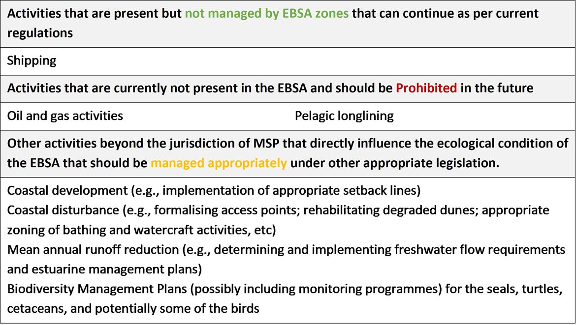
Furthermore, no new activities that can negatively impact the environment should be allowed in the EBSA, and some activities present in the EBSA do not need to be managed by EBSA zoning and can continue as per the current regulations. There are also some pressures on biodiversity features within the EBSA that originate from activities outside of these EBSA or beyond the jurisdiction of MSP. In support of maintaining the ecological integrity of and benefits delivered by the key biodiversity features, these other activities need to be appropriately managed by complementary initiatives.
Recommendations for other activities outside the EBSA or the MSP management jurisdiction.
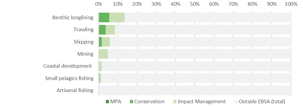
Proposed zonation of the EBSA, with the cumulative intensity footprint of activities within the EBSA (sorted highest to lowest) given relative to the national footprint of those activities to illustrate feasibility of management interventions.
Confirmation is required from the fishing and mining sectors as to the precise footprint of the activities that, in turn, could affect the management recommendations. In principle, the non-destructive fishing practices (benthic longlining and small pelagics fishing) are recommended to be Consent activities in the zones where they are currently present, and Prohibited in the zones where they are not currently present. Accommodating these activities is most important for benthic longlining because almost 15% of the national footprint of this activity is within the EBSA. For destructive fishing, i.e., trawling, this activity is not compatible with the management objectives of the EBSA Conservation Zone and it is recommended to be Prohibited. If it is currently present in the Conservation Zone, it is recommended that the zone boundary be modified to accommodate the activity in the Impact Management Zone, where it is recommended to be a Consent activity. Note that less than 10% of the national trawling footprint is present in the EBSA. Mining is also a destructive activity, and is similarly recommended to be Prohibited in the Conservation Zone and permitted as a Consent activity in the Impact Management Zone if it currently is present in that zone. Acknowledging the contribution of artisanal fishing to coastal households in the area surrounding the EBSA, this activity is accommodated in the EBSA zonation and is recommended to continue in both EBSA zones as a Consent activity. Note that artisanal fishing in the EBSA comprises only a very small proportion of the national footprint. Shipping is recommended to continue under current general rules and legislation. Thus, the EBSA zonation has no or minimal impact on the national footprint for the listed marine activities.
There are also several activities that are largely outside the EBSA but have downstream impacts to the biodiversity within the EBSA, e.g., from mean annual runoff reduction, coastal development, coastal disturbance, and wastewater discharge. The impacts should be managed, but principally fall outside the direct management and zoning of the EBSA. These existing activities are proposed as Consent activities for both EBSA zones, recognising that they should ideally be dealt with in complementary integrated coastal zone management in support of the EBSA. For example, rehabilitation of degraded dunes and formalising access points could support improved habitat for nesting shorebirds, and enhanced benefits for coastal protection during storm surges. Similarly, improved estuary management through development of appropriate freshwater flow requirements, estuarine management plans and wastewater management regulations can improve the ecological condition of the surrounding marine environment, in turn, improving water quality and safe conditions for human recreation. It is also recommended to consider developing and implementing Biodiversity Management Plans for the iconic/top predator species, e.g., seals, turtles, cetaceans and some of the seabirds and shorebirds in support of securing the biodiversity features for which the EBSA is recognised, where these are not already in place.
Research Needs
There are no specific research needs for this EBSA in addition to those for all EBSAs. However, filling these research needs is especially emphasised; given the remote nature of the area, it remains largely poorly understood (except for the Kunene Estuary). Much more baseline research and ongoing monitoring is needed to ensure that the key features of the EBSA are well managed. Further research will also be necessary to support the appropriate zoning and management of any additional marine protection in southern Angola.
Future Process
Angola’s preliminary national Marine Spatial Plan (Republic of Angola, 2022a), which incorporates the outcomes of the pilot central area (Republic of Angola et al., 2019), was approved in February 2023. This effectively formalizes the EBSA conservation and impact management zones as the national biodiversity zones for the MSP. The Conservation areas of the EBSA are being taken forward as the core of an emerging national MPA network. Particularly in Namibe, the key immediate issue is expanding marine protection in southern Angola, ideally with a transboundary extension into Namibia. This is being facilitated through ongoing regional alignment through the BCC.
Discussions and progress are underway, with advanced stakeholder consultation, including regarding refining the zoning and boundaries, and detailed sea use within the EBSA in southern Angola (Republic of Angola, 2021, 2022b). This is on track to become Angola’s first MPA.
The key steps that need to be taken for this EBSA include:
-
Finalising the required stakeholder process, boundaries, zones, and sea uses
-
Formal gazetting as an MPA
-
Resourcing MPA management, management plans, and staffing
-
Monitoring and evaluating the outcomes
References
Republic of Angola, 2022. Preliminary Proposal of the Marine Spatial Planning Plan in Angola: National Plan. Ministry of Fisheries and Sea, National Directorate for the Affairs of the Sea. Luanda, Angola.
Republic of Angola, 2019. Preliminary Proposal of the Marine Spatial Planning Plan in Angola: Palmeirinhas Pilot Area - Foz do Rio Tapado. Ministry of Fisheries and Sea, National Directorate for the Affairs of the Sea. Luanda, Angola.
Republic of Angola, 2022. Área de Conservação Marinha do Namibe - Produto 3 - Proposta dos Limites e do Zoneamento da Área de Conservação Marinha do Namibe. Preparado por: Instituto Nacional da Biodiversidade e Áreas de Conservação. Preparado para: Instituto Nacional da Biodiversidade e Conservação (INBC) – Ministério do Ambiente (MINAMB). Angola.
Republic of Angola, 2021. Relatório Técnico da Proposta de Área de Conservação Marinha do Namibe. Ministério da Agricultura e Pescas. Luanda, Angola.
UNEP-WCMC, IUCN, 2022. Protected Planet: The World Database on Protected Areas (WDPA) and World Database on Other Effective Area-based Conservation Measures (WD-OECM) [Online], September 2022. UNEP-WCMC and IUCN, Cambridge, UK. Available at: www.protectedplanet.net.
[Top]