EBSA Status Assessment and Management Recommendations
Ecological Condition, Threat Status, Current Protection and Key Features in the EBSA
Relevant Pressures and Activities (impact, extent) | Management Interventions Needed for the EBSA
Activity Evaluation Per Zone: Zoning Feasibility | Research Needs & Future Process
Back to the Angolan EBSA status and management home page

Ombaca Canyon and Seamount Complex is virtually pristine and is centred on rare offshore canyons, seamounts and key oceanographic features. Seasonal upwelling creates periods of intense primary productivity that enhance the productivity of fish. The EBSA also supports early life-history stages of fish. Biodiversity is not well known but likely includes fragile species, e.g., corals; turtles and cetaceans are present in the area.
Click here for the full EBSA description
[Top]
Ombaca Canyon and Seamount Complex has multiple ecological features and ecosystem types that need to be protected for the area to maintain the characteristics that give it its EBSA status. The criteria for which this EBSA ranks highly are: uniqueness and rarity; biological productivity; and naturalness. There are six offshore ecosystems represented, all of which are Least Concern and Not Protected. The EBSA focuses on offshore canyons, seamounts and key oceanographic features that relate to elevated productivity in the area. Although biodiversity has not yet been comprehensively surveyed, the area is known to support various turtle and cetacean species, and likely supports fragile habitat-forming species (e.g., corals and sponges) on the seamounts and in the canyons. The seasonal upwelling creates periods of intense primary productivity, that in turn promotes productivity of many fish species that are commercially important throughout the Benguela Current Large Marine Ecosystem, including supporting early life history stages of these and other key species.
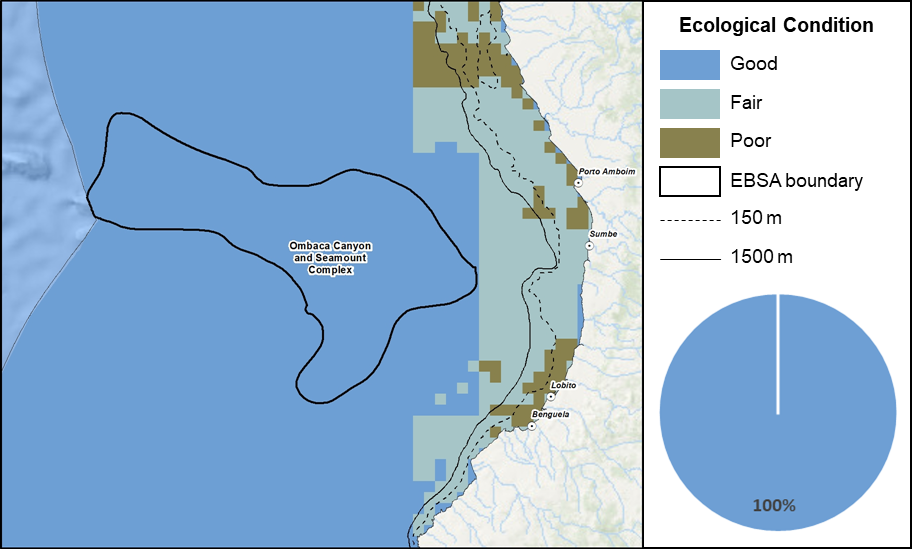
Ombaca Canyon and Seamount Complex proportion of area in each ecological condition category.
Currently, the entire area is in good ecological condition, with biodiversity patterns and processes assessed to be intact and natural / near natural. Consequently, all the ecosystems within the area are Least Concern. There are no MPAs in the area, and all of the ecosystem types are assessed as Not Protected.
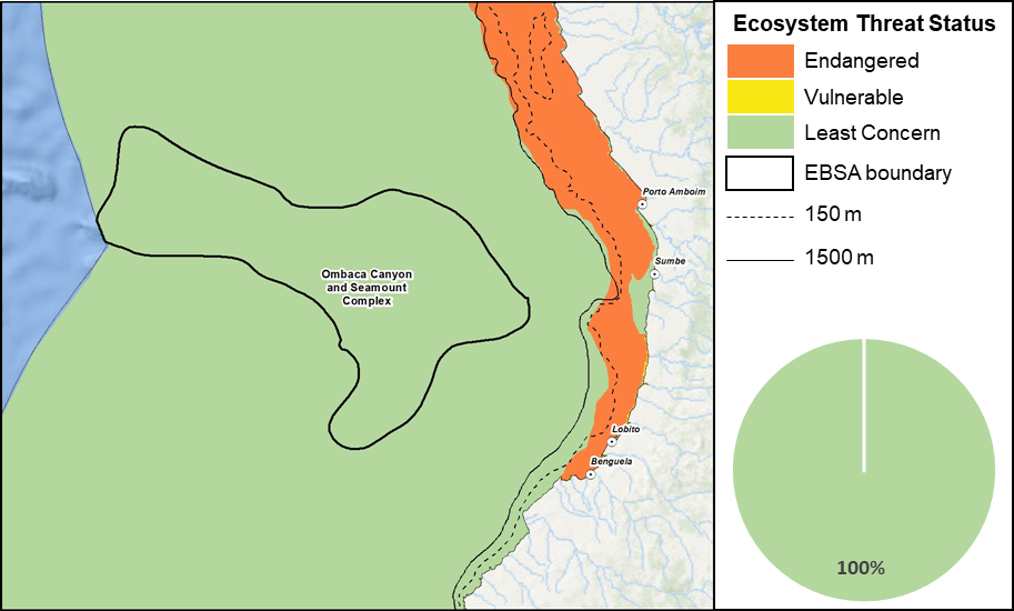
Ombaca Canyon and Seamount Complex proportion of area in each ecosystem threat status category.
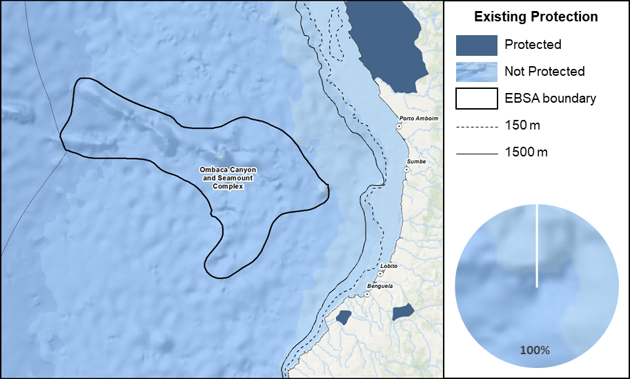
Ombaca Canyon and Seamount Complex proportion of area in a Marine Protected Area (MPA).
Threat status, protection level and ecological condition of ecosystem types in the EBSA. Other key features are also listed.
|
Feature
|
Threat Status
|
Protection Level
|
Condition (%)
|
|
Good
|
Fair
|
Poor
|
|
Ecosystem Types
|
|
Cunene Abyss
|
LC
|
NP
|
100.00
|
0.00
|
0.00
|
|
Kwanza Lower Slope
|
LC
|
NP
|
100.00
|
0.00
|
0.00
|
|
Kwanza Seamount
|
LC
|
NP
|
100.00
|
0.00
|
0.00
|
|
Kwanza Upper Slope
|
LC
|
NP
|
100.00
|
0.00
|
0.00
|
|
Lobito Upper Slope
|
LC
|
NP
|
100.00
|
0.00
|
0.00
|
|
Sumbe Upper Slope
|
LC
|
NP
|
100.00
|
0.00
|
0.00
|
|
Other Features
|
-
Turtles
-
Cetaceans
-
Angola-Benguela Front and areas of upwelling
|
[Top]
-
There are four major pressures present in this EBSA. Shipping is the most extensive pressure, which also has the highest cumulative pressure profile.
-
Key pressures in this EBSA that most directly impact the features for which the EBSA is described include: shipping, small pelagics fishing, benthic longlining, and trawling. These activities will need to be managed particularly well in order to protect the fragile benthic biodiversity and top predators/iconic species for which this EBSA is recognised.
-
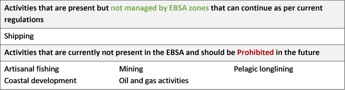
Activities in Angola that are not present in the EBSA include: artisanal fishing, coastal development, mining, oil and gas activities and pelagic longlining.
-
Note that the data of individual pressures used in the assessment were from global datasets, some of which were mapped at a coarser resolution than is displayed below (i.e., shipping and commercial fishing). The finer scale data are included to facilitate more accurate management recommendations. The fine-scale fishing data indicate fishing activity within the EBSA, although it is not clear which commercial fisheries this is reflecting. It will need to be confirmed with the various industries which fisheries are present because it will affect the management recommendations for those activities.
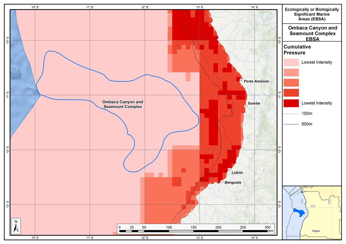
Map of cumulative pressure from all activities in the EBSA and surrounds. Darker reds indicate higher pressure intensity.
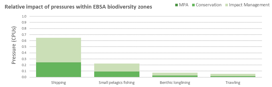
Pressure (in arbitrary cumulative pressure units, CPUs) summed for each pressure in the EBSA, per proposed EBSA biodiversity zone, ranked left (highest) to right (lowest) by the overall relative importance of pressures in this EBSA.
[Top]
Improved place-based protection of EBSA features should be pursued. In support of this, the EBSA is divided into a Conservation Zone and an Impact Management Zone, both comprising several areas within the EBSA. The aim of the Conservation Zone is to secure core areas of key biodiversity features in natural / near-natural ecological condition. Strict place-based biodiversity conservation is thus directed at securing key biodiversity features in a natural or semi-natural state, or as near to this state as possible. Activities or uses that have significant biodiversity impacts should be prohibited. Where possible and appropriate these areas should be considered for formal protection e.g., Marine Protected Areas or other effective area-based conservation measures (OECM). The aim of the Impact Management Zone is to manage negative impacts on key biodiversity features where strict place-based measures are not practical or not essential. In this zone, the focus is management of impacts on key biodiversity features in a mixed-use area, with the objective to keep biodiversity features in at least a functional state. Activities or uses which have significant biodiversity impacts should be strictly controlled and/or regulated. Within this zone, there should be no increase in the intensity of use or the extent of the footprint of activities that have significant biodiversity impacts. Where possible, biodiversity impacts should be reduced. As far as possible, the Conservation Zone was designed deliberately to avoid conflicts with existing activities. Note that there are no marine protected areas in this EBSA.
Proposed zonation of the EBSA into Conservation (medium green) and Impact Management (light green) Zones. MPAs are overlaid in orange outlines, with the extent within the EBSA given in dark green. Click on each of the zones to view the proposed management recommendations.
[Top]
Protection of features in the rest of the Conservation Zone may require additional Marine Protected Area declaration/expansion. Other effective conservation measures should also be applied via Marine Spatial Planning to ensure that the existing activities/uses are appropriately controlled to ensure compatibility of activities with the environmental requirements for achieving the management objectives of the EBSA Conservation and Impact Management Zones. Further, no new pressures should be extended into the Conservation Zone, even if they currently occur in the Impact Management Zone of the EBSA.
Recommended compatibility (consent1 or prohibited2) of activities currently present in the EBSA3 in the Conservation and Impact Management Zones
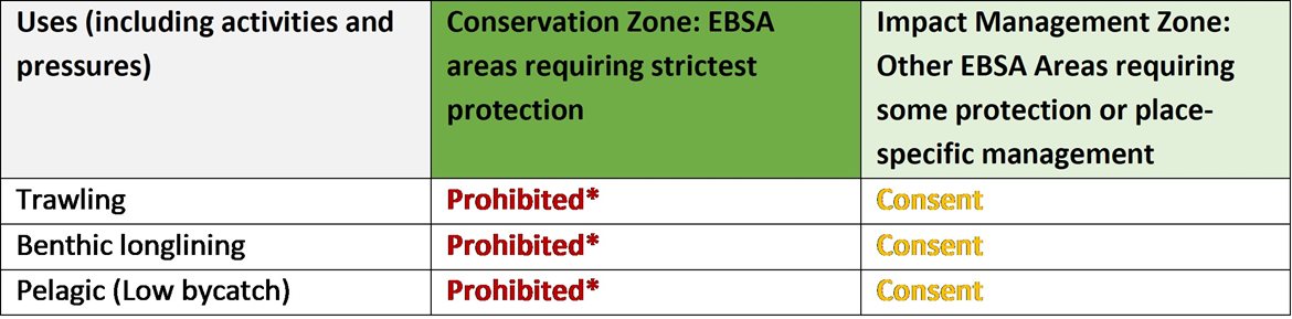
2Prohibited: An activity which is not allowed or should not be allowed because it is incompatible with maintaining the biodiversity objectives of the zone.1Consent: An activity which can continue in this zone subject to specific regulation and control.
*Not present in zone.
3Note that activities present in Angola that are not relevant to the EBSA have been excluded from the table (e.g., the harvested species does not occur in the area; or the industry operates at a depth outside the depth range of the EBSA).
Furthermore, no new activities that can negatively impact the environment should be allowed in the EBSA, and some activities present in the EBSA do not need to be managed by EBSA zoning and can continue as per the current regulations. Note that there are no marine protected areas in this EBSA.
Recommendations for other activities outside the EBSA or the MSP management jurisdiction.
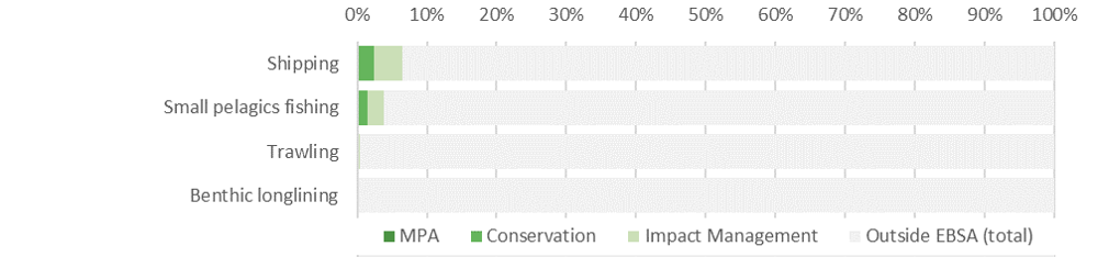
Proposed zonation of the EBSA, with the cumulative intensity footprint of activities within the EBSA (sorted highest to lowest) given relative to the national footprint of those activities to illustrate feasibility of management interventions.
Of the four activities present in Ombaca Canyon and Seamount Complex, shipping has the highest proportion of its national footprint within the EBSA. However, this is still <10% of the national footprint of this activity. It is recommended to continue in both the Conservation and Impact Management Zones under current general rules and legislation. Three fisheries appear to be present, none of which are currently within the Conservation Zone. Therefore, they are all recommended to be Prohibited activities in that zone. Benthic longlining and small pelagics fishing are non-destructive fisheries and are recommended to continue in the Impact Management Zone as Consent activities. If the industries confirm that they are present in the Conservation Zone, they are recommended to be Consent activities in that zone. Of these two industries, small pelagics fishing has a higher proportion of its national footprint in the EBSA; however, it is accommodated where it occurs. Trawling is also present in the Impact Management Zone, and is similarly recommended to continue as a Consent activity. Because trawling is a destructive fishing practice, it is recommended to be Prohibited in the Conservation Zone. Therefore, if this activity is confirmed to be present in the Conservation Zone, it is recommended that the zone boundary is changed to accommodate this activity in an Impact Management Zone. Thus, in all cases, the EBSA zonation has no or minimal impact on the national footprint for the listed marine activities.
Research Needs
In addition to the general research needs, more research is required for this particular EBSA to better establish the linkages between the benthic and pelagic systems. Once these linkages are better understood, it might ultimately require splitting the EBSA into a benthic and dynamic pelagic EBSA. Also, the link between the seamounts within and beyond Angola’s EEZ needs to be investigated, as well as the dynamics of the Angola-Benguela Front in Angola and in the adjacent ABNJ; this new information, subject to international processes, may require an extension of this EBSA into ABNJ.
Future Process
Angola’s preliminary national Marine Spatial Plan (Republic of Angola, 2022), which incorporates the outcomes of the pilot central area (Republic of Angola et al., 2019), was approved in February 2023. This effectively formalizes the EBSA conservation and impact management zones as the national biodiversity zones for the MSP. However, futher work and engagement is still required to clarify the details of the allowed uses of the zones, which will then require implementation, monitoring and management.
The Conservation areas of the EBSA are being taken forward as the core of an emerging national MPA network. A technical proposal has been prepared to support this, which has been through government review and revision, but the stakeholder processes have not yet begun. The key steps that need to be taken for this EBSA include:
-
Initiating the required stakeholder process
-
Negotiations around final MPA boundaries
-
Refining zones and their specific sea uses and regulations
-
Formal gazetting as an MPA
-
Resourcing MPA management, management plans, and staffing
-
Monitoring and evaluating the outcomes
References
Republic of Angola, 2022. Preliminary Proposal of the Marine Spatial Planning Plan in Angola: National Plan. Ministry of Fisheries and Sea, National Directorate for the Affairs of the Sea. Luanda, Angola.
Republic of Angola, 2019. Preliminary Proposal of the Marine Spatial Planning Plan in Angola: Palmeirinhas Pilot Area - Foz do Rio Tapado. Ministry of Fisheries and Sea, National Directorate for the Affairs of the Sea. Luanda, Angola.
[Top]