 |
The Walvis Ridge Namibia EBSA lies contiguous to the Walvis Ridge EBSA in the high seas. Together, these two EBSAs span the full extent of the significant hotspot track (seamount chain formed by submarine volcanism) that comprises the aseismic Walvis Ridge and the Guyot Province. This unique feature forms a submarine ridge running north-east to south-west from the Namibian continental margin to Tristan da Cunha and Gough islands at the southern Mid-Atlantic Ridge. The Walvis Ridge Namibia EBSA encompasses the globally rare connection of a hotspot track to continental flood basalt in the Namibian EEZ. Given the high habitat heterogeneity associated with the complex benthic topography, it is likely that the area supports a relatively higher biological diversity, and is likely to be of special importance to vulnerable sessile macrofauna and demersal fish associated with seamounts. Productivity in the Namibian portion of Walvis Ridge is also particularly high because of upwelling resulting from the interaction between the geomorphology of the feature and the nutrient-rich, north-flowing Benguela Current. Although there are fisheries operating over Walvis Ridge in northern Namibia, the EBSA focus area is currently in good condition.
[Top]
Open or collapse the legend as a sidebar by clicking the icon in the top left corner of the map. In the legend you can turn on/off the old/new extents of the EBSA. You can zoom in/out using the mouse or the +/- buttons on the map, and click on the features for more information.
[Top]
[Top]
NOTE: Read this here, or download the Word document on the right sidebar.
General Information
Summary
The Walvis Ridge Namibia EBSA lies contiguous to the Walvis Ridge EBSA in the high seas. Together, these two EBSAs span the full extent of the significant hotspot track (seamount chain formed by submarine volcanism) that comprises the aseismic Walvis Ridge and the Guyot Province. This unique feature forms a submarine ridge running north-east to south-west from the Namibian continental margin to Tristan da Cunha and Gough islands at the southern Mid-Atlantic Ridge. The Walvis Ridge Namibia EBSA encompasses the globally rare connection of a hotspot track to continental flood basalt in the Namibian EEZ. Given the high habitat heterogeneity associated with the complex benthic topography, it is likely that the area supports a relatively higher biological diversity, and is likely to be of special importance to vulnerable sessile macrofauna and demersal fish associated with seamounts. Productivity in the Namibian portion of Walvis Ridge is also particularly high because of upwelling resulting from the interaction between the geomorphology of the feature and the nutrient-rich, north-flowing Benguela Current. Although there are fisheries operating over Walvis Ridge in northern Namibia, the EBSA focus area is currently in good condition.
Introduction of the area
The aseismic Walvis Ridge is a seamount chain formed by hotspot submarine volcanism, some of which are guyots, that is connected to a continental flood basalt province in northern Namibia. The ridge presents a barrier between North Atlantic Deep Water to the north and Antarctic Bottom Water to the south. The surface oceanographic regime is the South Atlantic Subtropical Gyre bounded by the productive waters of the Benguela Current System and the Subtropical Convergence Zone. The feature described here is depth-bound around the 4000‑m isobath, and contains significant areas within the likely vertical extent of near-surface zooplankton migration (1000 m). Although biologically significant, data from research cruises are patchy and variable, however the greater area is known to support a high diversity of seabirds, some of which are threatened. Further, the steep slopes and seamounts that are characteristic of the ridge likely support enhanced primary production, abundance and species richness. Because this site comprises a complex of features and ecosystems that are connected by the same ecological processes, it is proposed as a Type 2 EBSA (sensu Johnson et al. 2018).
Description of the location
EBSA Region
South-Eastern Atlantic
Description of location
The Walvis Ridge extends obliquely (NE-SW) across the south east Atlantic Ocean from the northern Namibian shelf (18°S) to the Tristan da Cunha island group at the Mid-Atlantic Ridge (38°S). The part of the ridge that lies beyond national jurisdiction is included in the existing Walvis Ridge EBSA that has its north eastern boundary at the Namibian EEZ. The proposed Walvis Ridge Namibia EBSA is contiguous with this high seas EBSA, spanning only that portion of the ridge within Namibia’s national jurisdiction. Given the global rarity of the connection between a hotspot track and the continental flood basalt province, it is imperative that the full extent of this feature is encompassed within an EBSA, including the portion in the Namibian EEZ.
Area Details
Feature description of the area
Walvis Ridge is both a benthic and water column feature: it is a chain of seamounts that individually and collectively constitute an ecologically and biologically significant deep-sea feature, as also recognized by the Census of Marine Life project (CenSeam: http://censeam.niwa.co.nz). Walvis Ridge also includes a number of deep-sea features in addition to the seamounts and guyots, such as steep canyons, embayments formed by massive submarine slides, trough-like structures, a graben, abyssal plains, and a fossilized cold-water coral reef mound community (GEOMAR 2014). Based on these physical features, the ridge can be divided into three sections (GEOMAR 2014). The portion of the ridge within the proposed EBSA forms part of the northern section, which extends SW from the Namibian shelf, with a steep NW scarp, ridge-type seamounts, and guyots with rift arms (GEOMAR 2014).
The high habitat heterogeneity supports moderately diverse biological communities, including benthic macrofauna such as brachiopods, sponges, octocorals, deep-water hexacorals, gastropods, bivalves, polychaetes, bryozoans, cirriped crustaceans, basket stars, ascidians, isopods and amphipods (GEOMAR 2014). Presumably this diversity extends along the full extent of the ridge, and into the Namibian portion. Productivity seems to increase from SW to NE along Walvis Ridge, with sediment organic carbon and the abundance and diversity of phytoplankton communities increasing towards the Namibian shelf, likely reflecting patterns of nutrient transport and upwelling in the north-flowing Benguela Current that are more intense closer to the African continent (GEOMAR 2014).
This EBSA was not included in the original South Eastern Atlantic Workshop that was held in 2013 (UNEP/CBD/RW/EBSA/SEA/1/4) because it was highlighted only in a gap analysis of the national and regional EBSA networks, using systematic conservation planning (Holness et al., 2014). Further, new information has since become available following a recent research cruise (GEOMAR 2014), which has added certainty of the significance of the features. The EBSA boundary links tightly to important benthic features comprising the ridge (produced by combining GEBCO data with that from www.bluehabitats.org: see Harris et al., 2014, and data from Holness et al., 2014). Those features that are continuous with the ridge, as well as isolated hills that are in close proximity are included. The EBSA also includes areas with a high selection frequency in the regional gap analysis (Holness et al., 2014), which suggests that they are irreplaceable areas in the region.
Feature conditions and future outlook of the proposed area
The Walvis Ridge EBSA is primarily recognized as a geological feature but the biota in the area could be vulnerable to fishing (e.g., orange roughy; SEAFO report in FAO Statistical Area 47). The fisheries within the Namibian EEZ are managed by Namibia’s Ministry of Fisheries and Marine Resources. Oil exploration has already taken place within the EBSA, namely Welwitschia-1 well, which was drilled in 2014 at 20°11’9.79”S, 11°19’3.27”E. Although it was found to be dry, future drilling activities in the area are likely. The EBSA is largely in good condition, though some impacted areas exist on the far eastern edge (Holness et al., 2014).
The Walvis Ridge and Walvis Ridge Namibia EBSAs should ideally be merged because they both represent the same feature; however, the former is in the high seas and the latter is under national jurisdiction. Consequently, this merger will depend on international processes around EBSAs that span across country EEZs and ABNJ. It is thus recommended that ABNJ and BBNJ processes are engaged to understand the link between these two EBSAs and how they might be merged in the future.
References
BirdLife International. 2009. Designing networks of marine protected areas: exploring the linkages between Important Bird Areas and ecologically or biologically significant marine areas. Cambridge, UK: BirdLife International. www.cbd.int/doc/meetings/mar/ewbcsima- 01/other/ewbcsima-01-birdlife-02-en.pdf.
BirdLife International. 2010. Marine Important Bird Areas toolkit: standardised techniques for identifying priority sites for the conservation of seabirds at-sea. BirdLife International, Cambridge UK. Version 1.1: May 2010. www.birdlife.org/eu/pdfs/Marine_IBA_Toolkit_2010.pdf.
Census of Marine Life project CenSeam http://censeam.niwa.co.nz, http://seamounts.sdsc.edu.
Clark, M.R., Vinichenko, V.I., Gordon, J.D.M, Beck-Bulat, G.Z., Kukharev, N.N., Kakora, A.F. 2007. Large scale distant water trawl fisheries on seamounts. Pp. 361-412 in Seamounts: Ecology, Fisheries and Conservation. Fish and Aquatic Resources Series 12, T.J. Pitcher, T. Morato, P.J.B. Hart, M.R. Clark, N. Haggan and R.S. Santos, eds, Blackwell Publishing, Oxford.
Durán Muñoz, P., Sayago-Gil, M., Murillo, F.J., Del Río, J.L., López-Abellán, L.J., Sacau, M., Serralde, R. 2012. Actions taken by fishing nations towards identification and protection of vulnerable marine ecosystems in the high seas: The Spanish case (Atlantic Ocean). Marine Policy, 36: 536–543.
FAO FIRMS (Fishery Resources Monitoring System) firms.fao.org.
GEBCO (General Bathymetric Chart of the Oceans) Available at http://www.gebco.net/data_and_poducts/gridded_bathymetry_data/.
GEOMAR, 2014. RV SONNE Fahrtbericht / Cruise Report SO233 WALVIS II: Cape Town, South Africa - Walvis Bay, Namibia: 14.05-21.06.2014. Hoernle, K., Werner, R., Lüter, C (eds). Helmholtz-Zentrum für Ozeanforschung Kiel, Germany: Nr. 22 (N. Ser.), 153 pp.
Harris, L.R., Nel, R., Oosthuizen, H., Meyer, M., Kotze, D., Anders, D., McCue, S., Bachoo, S. 2017. Managing conflicts between economic activities and threatened migratory marine species towards creating a multi-objective blue economy. Conservation Biology, in press.
Harris, P.T., Macmillan-Lawler, M., Rupp, J., Baker, E.K. 2014. Geomorphology of the oceans. Marine Geology, 352: 4-24.
Holness, S., Kirkman, S., Samaai, T., Wolf, T., Sink, K., Majiedt, P., Nsiangango, S., Kainge, P., Kilongo, K., Kathena, J., Harris, L., Lagabrielle, E., Kirchner, C., Chalmers, R., Lombard, M. 2014. Spatial Biodiversity Assessment and Spatial Management, including Marine Protected Areas. Final report for the Benguela Current Commission project BEH 09-01.
Jacobs, C.L., Bett, B.J. 2010. Preparation of a bathymetric map and GIS of the South Atlantic Ocean: a review of available biologically relevant South Atlantic Seamount data for the SEAFO Scientific Committee. National Oceanographic Centre Southampton, Research and consultancy Report No. 71 (unpublished manuscript).
Johnson, D.E., Barrio Froján, C., Turner, P.J., Weaver, P., Gunn, V., Dunn, D.C., Halpin, P., Bax, N.J., Dunstan, P.K., 2018. Reviewing the EBSA process: Improving on success. Marine Policy 88, 75-85.
OBIS. 2017. Summary statistics of biodiversity records in the Walvis Ridge EBSA. (Available: Ocean Biogeographic Information System. Intergovernmental Oceanographic Commission of UNESCO. www.iobis.org. Accessed: 2017-07-27).
Perez, J.A.A, dos Santos Alves, E., Clark, M.R., Bergstad, O.A., Gebruk, A., Azevedo Cardoso, I., Rogacheva, A. 2012. Patterns of life on the southern Mid-Atlantic Ridge: Compiling what is known and addressing future research. Oceanography, 25: 16-31.
Reid, T., Ronconi, R., Cuthbert, R., Ryan, P.G. 2014. The summer foraging ranges of adult spectacled petrels Procellaria conspicillata. Antarctic Science, 26: 23-32.
Rogers, A.D., Gianni, M. 2010. The implementation of UNGA Resolutions 61/105 and 64/72 in the Management of Deep-Sea Fisheries on the High Seas. Report prepared for the Deep Sea Conservation Coalition, International Programme on the State of the Ocean, London UK. 97 pp.
Sanchez, P., Alvarez, J.A. 1988. Scaeurgus unicirrhus (Orbigny, 1840) (Cephalopoda Octopodidae): First record from the South-east Atlantic. South African Journal of Marine Science, 7: 69-74.
Zibrowius, H., Gili, J.M. 1990. Deep-water Scleractinia (Cnidaria Anthozoa) from Namibia, South Africa and Walvis Ridge, southeastern Atlantic. Scientia Marina, 54: 19-46.
Other relevant website address or attached documents
Summary of habitat types and threat status for Walvis Ridge Namibia. Data from Holness et al. (2014).
|
Threat Status
|
Habitat Type
|
Area (km2)
|
Area (%)
|
|
Vulnerable
|
Central Namib Shelf Edge
|
18,113
|
26.1
|
|
|
Kunene Shelf Edge
|
6,458
|
9.3
|
|
Vulnerable Total
|
|
24,571
|
35.4
|
|
Least Threatened
|
Kunene Abyss
|
5,920
|
8.5
|
|
|
Kunene Lower Slope
|
8,664
|
12.5
|
|
|
Kunene Seamount
|
3,818
|
5.5
|
|
|
Kunene Upper Slope
|
2,298
|
3.3
|
|
|
Namib Abyss
|
383
|
0.6
|
|
|
Namib Lower Slope
|
16,573
|
23.9
|
|
|
Namib Seamount
|
2,290
|
3.3
|
|
|
Namib Upper Slope
|
4,931
|
7.1
|
|
Least Threatened Total
|
|
44,877
|
64.6
|
|
Grand Total
|
|
69,448
|
100.0
|
Assessment of the area against CBD EBSA criteria
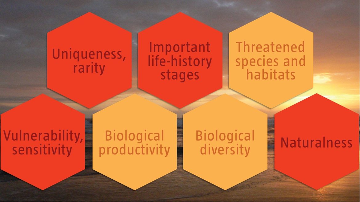
C1: Uniqueness or rarity High
Justification
As the only extensive seamount chain off of the Mid-Atlantic Ridge in the Southeast Atlantic, the Walvis Ridge is a unique geomorphological feature. It is also one of the few hotspot tracks on earth that connects to continental flood basalt. This rare connection falls within the Walvis Ridge Namibia EBSA.
C2: Special importance for life-history stages of species High
Justification
Seamount chains may facilitate connectivity between individual seamounts over extensive distances. The varied topography and geomorphology support demersal fish resources (based on demersal fisheries records in locations shallower than 2000 m). The varied bathymetry dictates the distribution area and provides significant habitat for bentho-pelagic species (e.g., hotspots for orange roughy), and is also likely to do so for epi-pelagics (Clark et al., 2007, Rogers and Gianni, 2010). These seamounts are significant habitats for cold-water corals and sponges (Zibrowius and Gili, 1990; GEOMAR 2014). Thus, the Walvis Ridge is of special importance for sessile macrofauna and for demersal fish associated with seamounts (FAO FIRMS species distribution maps) (http://firms.fao.org). It includes parts of the foraging areas for globally threatened seabirds, such as the Tristan Albatross (Diomedea dabbenena), Wandering Albatross (Diomedea exulans) and Atlantic Yellow-nosed Albatross (www.seabirdtracking.org). The series of seamounts provides a potential stepping stone feature for organisms from coast to mid ocean (e.g., dispersion of the benthic octopod, Scaeurgus unicirrhus; Sanchez and Alvarez, 1988).
C3: Importance for threatened, endangered or declining species and/or habitats Medium
Justification
Bluefin and big-eye tuna occur in the area (e.g., FishBase), and orange roughy hotspots within the area are known (SEAFO information). Several threatened seabird species also use the Namibian portion of the Walvis Ridge for foraging, e.g., the endangered Atlantic Yellow-nosed Albatross (www.seabirdtracking.org; BirdLife International, 2017).
C4: Vulnerability, fragility, sensitivity, or slow recovery High
Justification
Habitat-forming sessile megafauna are fragile and vulnerable to bottom contact fishing gears and slow to recover from damage. Habitat prediction models and observational data (Durán Muñoz et al., 2012, GEOMAR 2014, Perez et al., 2012) indicate presence of cold-water corals and sponges, and other delicate fauna such as basket and feather stars (see also the OBIS database for species records: http://www.iobis.org/explore/#/area/351). Based on empirical evidence (e.g., observations from Spanish/Namibian cruises on the Valdivia Bank, and along the whole ridge; GEOMAR 2014) the seamounts and deep-sea features along the Walvis Ridge have sensitive habitats, biotopes and species, justifying high criterion ranking.
C5: Biological productivity Medium
Justification
Productivity appears to increase from SW to NE along the Walvis Ridge, as seen in the sediment organic carbon load, and abundance and diversity of plankton that both increase closer to the Namibian shelf (GEOMAR 2014). Several seamounts also extend into the photic zone and may have enhanced primary production. Significant areas are within the likely vertical range of epipelagic zooplankton migration (Jacobs and Bett, 2010).
C6: Biological diversity Medium
Justification
Data on biological diversity associated with the Walvis Ridge are limited, however there are some data on seabirds, fish, and benthic mega-, macro- and meiofauna (see Perez et al., 2012 for a review, and GEOMAR 2014), including 17 922 records of 907 species listed on the OBIS database (OBIS 2017). Observations and the range of habitats created by the seamount chain and immediately adjacent abyssal area suggest comparatively higher diversity of ecosystems, habitats, communities, and species. This has been confirmed to some extent through bathymetric/geological surveys and biological sampling of the benthos, which revealed a variety of benthic macrofauna (GEOMAR 2014). Presumably the comparatively higher biodiversity associated with this geological feature extends into the Namibian portion of the ridge that comprises the Namibian EBSA focus area.
C7: Naturalness High
Justification
Human influence along the Walvis Ridge is largely historic, fisheries were and are mainly confined to seamount summits (SEAFO information, Clark et al., 2007, and relevant papers cited in Perez et al., 2012), and oil exploration drilling has been limited to date. Apart from seamounts that are likely to have been impacted by bottom-fishing, the remainder of the area is considered to have a high degree of naturalness. The EBSA focus area is largely in good condition, though some impacted areas exist on the far eastern edge (Holness et al., 2014).
Additional Information
Additional criteria: BirdLife Important Bird Areas Criteria (BirdLife 2009, 2010) A1 Regular presence of threatened species; A4ii >1% of the global population of a seabird.
[Top]