 |
The Namaqua Fossil Forest itself is a small (2 km2) seabed outcrop composed of fossilized yellowwood trees in the 136-140 m depth range, approximately 30 km offshore on the west coast of South Africa. The EBSA boundaries are larger at approximately 25 km by 35 km as this is necessary to accommodate likely extended area of the feature, which is not precisely known. The fossilized tree trunks have been colonized by fragile, habitat-forming scleractinian corals, confirmed by images from submersible surveys. The outcrops are composed of laterally extensive slabs of rock of dimensions >5 x <1 x <0.5 m. Based on interpretations of regional side scan sonar, the outcrop is believed to be unique to the area. The site is un-mined although it falls within a current diamond mining lease area; however, there is a “no go” buffer area around the known locations of the fossils. Hard grounds have been reported north of the original fossil forest discovery that are hypothesized to be part of this fossil forest. Further, a newly described habitat-forming sponge is present in the area. In summary, the Namaqua Fossil Forest is a unique feature with substantial structural complexity that is highly vulnerable to benthic impacts.
[Top]
Open or collapse the legend as a sidebar by clicking the icon in the top left corner of the map. In the legend you can turn on/off the old/new extents of the EBSA. You can zoom in/out using the mouse or the +/- buttons on the map, and click on the features for more information.
[Top]
4 new references added; relatively minor editing of the previous description. No further research has been conducted in the area.
[Top]
NOTE: Read this here, or download the Word document on the right sidebar.
General Information
Summary
The Namaqua Fossil Forest itself is a small (2 km2) seabed outcrop composed of fossilized yellowwood trees in the 136-140 m depth range, approximately 30 km offshore on the west coast of South Africa. The EBSA boundaries are larger at approximately 25 km by 35 km as this is necessary to accommodate likely extended area of the feature, which is not precisely known. The fossilized tree trunks have been colonized by fragile, habitat-forming scleractinian corals, confirmed by images from submersible surveys. The outcrops are composed of laterally extensive slabs of rock of dimensions >5 x <1 x <0.5 m. Based on interpretations of regional side scan sonar, the outcrop is believed to be unique to the area. The site is un-mined although it falls within a current diamond mining lease area; however, there is a “no go” buffer area around the known locations of the fossils. Hard grounds have been reported north of the original fossil forest discovery that are hypothesized to be part of this fossil forest. Further, a newly described habitat-forming sponge is present in the area. In summary, the Namaqua Fossil Forest is a unique feature with substantial structural complexity that is highly vulnerable to benthic impacts.
Introduction of the area
The Namaqua Fossil Forest is a small (2 km2) seabed outcrop composed of fossilized yellowwood trees in the 136-140 m depth range on the mid-shelf off the Namaqualand coast in South Africa. The EBSA boundaries are larger at approximately 25 km by 35 km as this is necessary to accommodate likely extended area of the feature which is not precisely known. The area is approximately 30 km offshore between Port Nolloth and Kleinsee. Fossilized tree trunks have been colonized by fragile, habitat-forming scleractinian corals. Based on regional side-scan sonar interpretations, the outcrop is believed to be unique to the area. Fragments of fossil tree trunks were, however, recovered from mined areas about 60 km away from this site but those fragments are no longer in-situ and were removed from the seabed. The site is within the productive southern Benguela ecosystem but there is no information on local-scale oceanography for this area.
Description of the location
EBSA Region
South-Eastern Atlantic
Description of location
This area occurs on the mid-shelf in the 136-140 m depth range off the Namaqualand coast in South Africa. It is entirely within the EEZ of South Africa.
Geo-Location
SEA_41_EBSA.geojson
Area Details
Feature description of the area
This is a benthic feature composed of laterally extensive slabs of rock of lengths greater than 5 m and usually less than 1 m in width. The fossilized wood is reported to extend to 0.5 m in height although the geology of the broader area includes erosion-resistant, high-relief areas (up to 5 m) (Stevenson and Bamford 2003). The lithology has not been sampled directly, but is believed to be claystone. According to in-situ observations during submersible surveys, the fossilized wood has been colonized by scleractinian corals. Apparently, no biological sampling has been conducted previously at the site, with research activities being focused rather on the geology of the area. Two species of fossil wood were documented in the area, both from the Podocarpidae family; Podocarpus jago and P. umzambense, the former being a species described from this site (Bamford & Stevenson, 2002).
Since the original description and delineation of this EBSA, more recent surveys in the area have revealed hard grounds immediately north of the known location of the fossil forest, which are believed to be part of the same feature. Further, a newly described habitat-forming sponge has been recorded in the area (Samaai et al., 2017). Consequently, the boundary of the Namaqua Fossil Forest has been expanded to cover a broader area, which includes the delineation of a currently proposed MPA in South Africa. Although the boundary is still a geometric shape, the revision has improved the precision of the delineation by encompassing a more realistic representation of the full extent of the feature. More dedicated research in this area is required to refine the boundary further to the actual extent of the feature rather than this current approximation. Consequently, this site is presented as a Type 3 EBSA: Spatially stable features whose individual positions are not known (sensu Johnson et al., 2018).
Feature conditions and future outlook of the proposed area
The in-situ surveys of this unique site showed large, intact, fossilized tree trunks that support habitat-building corals and sponges. The site is considered to be unmined. It used to fall within a mining licence area (South African Sea Area MPT 25/2011 (in Concessions 5C and 4C)) where De Beers Consolidated Mines held a marine diamond mining right, which they have subsequently abandoned. Since then, Belton Park Trading 127 (Pty) Ltd have been granted Prospecting Rights for marine diamonds in Concessions 2C, 3C, 4C and 5C, which overlaps with this EBSA (in 4C and 5C). However, the Basic Assessment Report requires a 250 m “no-go” buffer around all known locations of fossilized yellowwood trees (CCA Environmental (Pty) Ltd, 2015). Currently, sampling operations have been undertaken in Concession 2C and 3C, but not near the EBSA (Andrea Pulfrich, pers. comm). There is no known future research planned for the area.
References
Bamford, M.K., Stevenson, I.R. 2002. A submerged Late Cretaceous Podocarpus Forest, West Coast, South Africa. South African Journal of Science, 98: 181-185.
CCA Environmental (Pty) Ltd. 2015. Marine Sediment Sampling Activities in Various Diamond Mining Concession Areas, West Coast, South Africa. Draft Basic Assessment Report. Prepared for: Department of Environmental Affairs, on behalf of: Belton Park Trading 127 (Pty) Ltd. IMD01PBA/DBAR/REV.0, 130 pp.
FAO, 2006. Management of Demersal Fisheries Resources of the Southern Indian Ocean. FAO Fisheries Circular No. 1020 FAO Rome 2006.
FAO, 2009. Annex F of the Report of the Technical Consultation on International Guidelines for the Management of Deepsea Fisheries in the High Seas. Rome, 4–8 February and 25-29 August 2008.
Holness, S., Kirkman, S., Samaai, T., Wolf, T., Sink, K., Majiedt, P., Nsiangango, S., Kainge, P., Kilongo, K., Kathena, J., Harris, L., Lagabrielle, E., Kirchner, C., Chalmers, R., Lombard, M. 2014. Spatial Biodiversity Assessment and Spatial Management, including Marine Protected Areas. Final report for the Benguela Current Commission project BEH 09-01.
Johnson, D.E., Barrio Froján, C., Turner, P.J., Weaver, P., Gunn, V., Dunn, D.C., Halpin, P., Bax, N.J., Dunstan, P.K., 2018. Reviewing the EBSA process: Improving on success. Marine Policy 88, 75-85.
Lagabrielle, E. 2009. Preliminary report: National Pelagic Bioregionalisation of South Africa. Cape Town: South African National Biodiversity Institute.
Rogers, A.D., Clark, M.R, Hall-Spencer, K.M., Gjerde, K.M. 2008. The Science behind the Guidelines: A Scientific Guide to the FAO Draft International Guidelines (December 2007) For the Management of Deep-Sea Fisheries in the High Seas and Examples of How the Guidelines May Be Practically Implemented. IUCN, Switzerland.
Samaai, T., Maduray, S., Janson, L., Gibbons, M.J., Ngwakum, B., Teske, P.R. 2017. A new species of habitat–forming Suberites (Porifera, Demospongiae, Suberitida) in the Benguela upwelling region (South Africa). Zootaxa: 4254, 49-81.
Sink, K., Holness, S., Harris, L., Majiedt, P., Atkinson, L., Robinson, T., Kirkman, S., Hutchings, L., Leslie, R., Lamberth, S., Kerwath, S., von der Heyden, S., Lombard, A., Attwood, C., Branch, G., Fairweather, T., Taljaard, S., Weerts, S., Cowley, P., Awad, A., Halpern, B., Grantham, H., Wolf T. 2012. National Biodiversity Assessment 2012: Technical Report. Volume 4: Marine and Coastal Component. South African National Biodiversity Institute, Pretoria.
Sink, K.J., van der Bank, M.G., Majiedt, P.A., Harris, L.R., Atkinson, L., Karenyi, N., Kirkman, S. (eds) 2019. National Biodiversity Assessment 2018 Technical Report Volume 4: Marine Realm. South African National Biodiversity Institute, Pretoria. http://hdl.handle.net/20.500.12143/6372.
Sink, K.J., Wilkinson, S., Atkinson, L.J., Sims, P.F., Leslie, R.W., Attwood, C.G. 2012b. The potential impacts of South Africa’s demersal hake trawl fishery on benthic habitats: historical perspectives, spatial analyses, current review and potential management actions. Unpublished report. Cape Town: South African National Biodiversity Institute.
Stevenson, R., Bamford, M.K. 2003. Submersible-based observations of in-situ fossil tree trunks in Late Cretaceous seafloor outcrops, Orange Basin, western offshore, South Africa. South African Journal of Geology 106: 315-326.
Status of submission
The Namaqua Fossil Forest was recognized as meeting EBSA criteria by the Conference of the Parties. The revised description and boundaries still need to be submitted to COP for approval.
COP Decision
dec-COP-12-DEC-22
Assessment of the area against CBD EBSA criteria
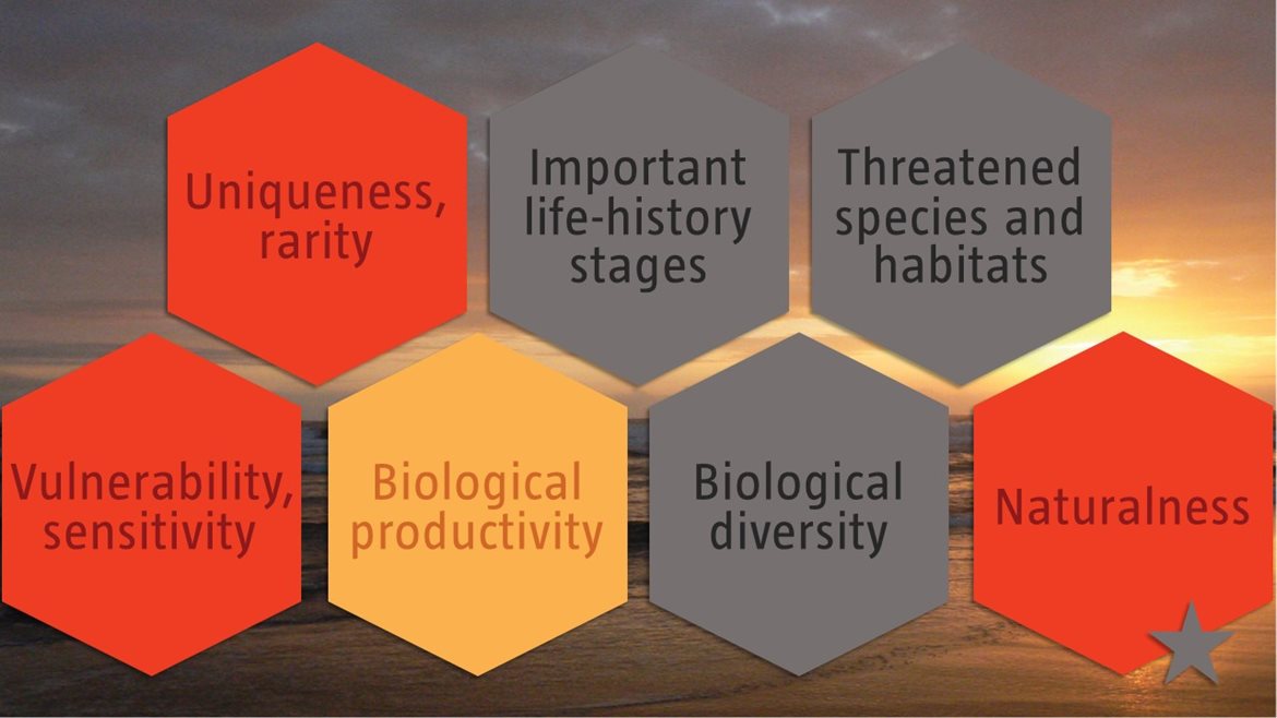
C1: Uniqueness or rarity High
Justification
Based on interpretations of regional side-scan sonar covering more than 2300 km2 between the area offshore of Chamais Bay in Namibia and offshore of the Buffels River in South Africa, there are no other known in situ fossilized yellowwood forests in the region (Stevenson and Bamford 2003). Further, the published images of in situ habitat-building corals prove this site to be one of the few confirmed localities of in situ cold-water corals in the region (Stevenson and Bamford 2003). Other fragments of fossil tree trunks were recovered from test-mine areas north-west of the area that meets the EBSA criteria, but these were buried fragments (Stevenson and Bamford 2003).
C2: Special importance for life-history stages of species No information
Justification
Little is known about the biodiversity and ecology of this small area (Sink et al., 2012a).
C3: Importance for threatened, endangered or declining species and/or habitats No information
Justification
Little is known about the local-scale biodiversity and ecology of this small area (Sink et al., 2012a). However, at a national scale, the most recent map of ecosystem types indicates that there are four ecosystem types present in the area, all of which are Least Concern (Sink et al., 2019).
C4: Vulnerability, fragility, sensitivity, or slow recovery High
Justification
The fossilized wood, accompanying cold-water coral colonies, and habitat-forming sponges are considered vulnerable to any activities that could impact on the seabed (FAO 2006, Rogers et al., 2008, FAO 2009, Sink et al., 2012a,b).
C5: Biological productivity Medium
Justification
This small localized area is unlikely to be more or less productive than the area surrounding it, but it does occur within the productive Southern Benguela ecosystem (Lagabrielle 2009, Sink et al., 2012a).
C6: Biological diversity No information
Justification
Little is known about the biodiversity and ecology of this small area (Sink et al., 2012a). However, the most recent map of ecosystem types indicates that there are four ecosystem types present in this small area (Sink et al., 2019).
C7: Naturalness High
Justification
The area has some overlap with a diamond mining lease area but apparently, it has not yet been mined (Leslie Roos, De Beers, South Africa pers. comm.). Although there is currently no mining within this offshore diamond mining lease, the future of mining in the area is uncertain (Sink et al., 2011, 2012a). Based on a cumulative-pressures assessment of known activities and impacts, almost the entire area (>99%) is in good ecological condition (Sink et al., 2019), and there is no known fishing activity within the site.
Other relevant website address or attached documents
Summary of ecosystem types and threat status for Namqua Fossil Forest. Data from Sink et al. (2019).
|
Threat status
|
Ecosystem Type
|
Area (km2)
|
Area (%)
|
|
Least Concern
|
Namaqua Mid Shelf Rock Outcrops
|
20.1
|
2.4
|
|
|
Namaqua Muddy Mid Shelf Mosaic
|
331.2
|
39.8
|
|
|
Namaqua Sandy Mid Shelf
|
230.0
|
27.7
|
|
|
Southern Benguela Muddy Sands
|
250.3
|
30.1
|
|
Grand Total
|
|
831.6
|
100.0
|
[Top]