 |
The proposed Bentiaba EBSA includes 190 km of coastline, extends about 50 km offshore in the north and 300 km offshore in the south, and spans a total area of 35 631 km2. It is located along the Bentiaba coast in the south of Lucira (Namibe province). The morphology of the seabed in this area suggests that the underlying geology comprises sandy, muddy and rocky substrates. In the southern portion, the continental shelf drops steeply, reaching deep depths very near to the coast. This contributes to a key influence of coastal upwelling in driving high productivity in the area. The EBSA includes 24 different habitat types, ranging from intertidal to abyssal types, and including seamounts and canyons. In turn, the diversity of species within this area is particularly high compared to the surrounding areas. The proposed area is currently subjected to very few pressures, and thus most of the site is in a highly natural condition. It is also recognized as a priority area for marine biodiversity ine the Benguela Current Large Marine Ecosystem.
[Top]
Open or collapse the legend as a sidebar by clicking the icon in the top left corner of the map. In the legend you can turn on/off the old/new extents of the EBSA. You can zoom in/out using the mouse or the +/- buttons on the map, and click on the features for more information.
[Top]
NOTE: Read this here, or download the Word document on the right sidebar.
General Information
Summary
The proposed Bentiaba EBSA includes 190 km of coastline, extends about 50 km offshore in the north and 300 km offshore in the south, and spans a total area of 35 631 km2. It is located along the Bentiaba coast in the south of Lucira (Namibe province). The morphology of the seabed in this area suggests that the underlying geology comprises sandy, muddy and rocky substrates. In the southern portion, the continental shelf drops steeply, reaching deep depths very near to the coast. This contributes to a key influence of coastal upwelling in driving high productivity in the area. The EBSA includes 24 different habitat types, ranging from intertidal to abyssal types, and including seamounts and canyons. In turn, the diversity of species within this area is particularly high compared to the surrounding areas. The proposed area is currently subjected to very few pressures, and thus most of the site is in a highly natural condition. It is also recognized as a priority area for marine biodiversity ine the Benguela Current Large Marine Ecosystem.
Introduction of the area
A key characteristic of the oceanography on the Angolan continental shelf is the upwelling process that starts in May-June, reaches its peak in August-September and probably ends near the end of the year. This upwelling results in intense primary production that in turn influences the production and distribution of fish, thereby playing a critical ecological role for ecosystems in the area. It is known that fish species often adapt their reproductive strategies to ocean currents and productivity cycles, so spawning times and the distribution of the main Angolan species tend to coincide with the observed seasonal oceanographic patterns (Sætersdal et al., 1999).
The offshore ecosystems in the area have not been sufficiently surveyed to allow for a full understanding of their ecological and biological importance. However, it can be said that many seamounts support endemic species and poorly known biodiversity (Sink, 2004). The coastal ecosystems are better researched in Angola, with these ecosystems characterized by diverse communities. Invertebrate animal diversity is represented by Echinodermata, Ctenophora, Sipunculida, Polychaeta, Bryozoa, Brachiopoda, Tunicata and Pycnogonida groups. The Crustaceans and Molluscs, which are of commercial importance, also constitute very important groups in the area (Migoto and Marques, 2003 In: Silva, 2015). Vertebrate communities are similarly diverse, with turtles, marine and coastal birds, seals, dolphins and whales (e.g., the humpback whale (Megaptera novaeangliae) and the Blue whale (Balaenoptera musculus)) all being of great importance. The small pelagic fish found in Angolan waters are made up of sardinellas (Sardinella aurita and Sardinella madeirensis) and mackerel (Cunene Horse Mackerel and Cape Horse Mackerel), with the latter being the major fisheries resource species in the area. Other important pelagic species include the Engraulis encrasicolus and the Sardinops ocellata (Silva, 2015) that originate from the temperate waters of Namibia, limited in the north by the Baía dos Tigres Bank (Bianchi 1986 In: Silva 2015). The yellowfin tuna (Thunnus albacares) and the bigeye tuna (Thunnus obesus) are the most important species of large pelagic fish.
In the EBSA specifically, there are 24 habitat types. Although the area has not been well sampled, it is presumed to be diverse based on the different types of communities associated with those 24 habitats. The shore types include boulder and rocky shores, mixed and sandy shores, with islands shelf, seamount, slope and abyss types represented offshore. Because this site comprises a collection of features and ecosystems that are connected by the same ecological processes, it is proposed as a Type 2 EBSA (sensu Johnson et al. 2018).
Description of the location
EBSA Region
South-Eastern Atlantic
Description of location
The area includes 190 km of coastline and extends about 50 km offshore in the north and 300 km offshore in the south. The area totals approximately 35 631 km2. It is located along the Bentiaba coast, south of Lucira in the province of Namibe. The proposed EBSA lies entirely within Angola’s national jurisdiction.
Area Details
Feature description of the area
The morphology of the seabed in this area suggests that the underlying geology comprises sandy, muddy and rocky substrates. (ARC, 2013). The proposed EBSA spans the section of the Namibe coast where the continental shelf is very narrow because it drops steeply, reaching deep depths very near to the shore. Beyond the 200 m isobath, the continental shelf slopes down to a -3000-m deep abyss with a very smooth and regular gradient. Based on available information for northern Angola, deep-water sediments seem to be dominated by silts and clays with a very high organic carbon content. There are many offshore geomorphic features in this area that are not described in the maritime charts, but that were mapped for the BCLME (Holness et al., 2014), including canyons and seamounts, around which the proposed EBSA is delineated. Even though the EBSA is in an “L shape”, the features in both of these “arms” are similar.
Ocean currents and circulation patterns in the region include a complex set of flows that are linked to a larger system of currents in the tropical east Atlantic. The dominant circulation patterns of the Angolan central and southern continental shelf are driven by the warm Angola Current that moves southwards, and where this current meets the cold Benguela Current at the Angola-Benguela Front (Moroshkin et al., 1970; Meeuwis and Lutjeharms, 1990; Shannon and O'Toole, 1998; and Lass et al., 2000). The Angola Current is fast and stable and penetrates up to depths of 250-300 m, covering both the continental shelf and slope. The typical current speed is 50 cm.s-1 but it can reach or even exceed speeds of 70 cm.s-1 (Moroshkin et al., 1970). The origin of this current, at least on the surface, is the southeastern arm of the South Equatorial Counter-Current.
The Angola-Benguela Front forms where the warm Angola Current, moving south, meets with the cold Benguela Current, moving north. This phenomenon occurs typically in the south of the Bay of Lobito at 14°S – 16°S and is a semi-permanent oceanographic feature. The gradients of temperatures at the surface reach 4°C.°latitude-1, but on average are 1.5°C.°latitude-1. This Front varies by season, reaching maximum levels in the summer when it is wider and is located further south, compared to winter when the front retracts towards the north and has a lower temperature gradient. These variations are related to the seasonality of the Angola Current (Meeuw and Lutjeharms, 1990). Episodic inflows of warm, saline water towards the south may displace the Angola-Benguela Front up to 23°S (Shannon et al, 1986), with effects associated with the general level of biological productivity in the north of the system. Shannon et al (1986) classified these events as ‘Niños de Benguela’ because they are comparable to the ‘El Niño’ of the tropical east Pacific Ocean. However, a northward shift of the Angola-Benguela Front has never been observed on this same scale.
The thermoclines are well developed on the Angolan continental shelf, with depths above 10 - 20m of mixed strata (Van Bennekom & Berger, 1984). Temperature gradients may reach 0.32 °C.m-1 at depths of 25 - 50m, with corresponding firm salinity gradients (Lass et al. 2000). The thermoclines are interrupted by the coastal upwelling along the entire Angolan coast. This coastal upwelling is the most significant oceanographic characteristic of the region and starts in May-June, reaches its peak in August-September and probably ends near the end of the year. Upwelling results from interactions between the main currents of the region and generates areas of divergence both in the continental margin and along the equator. The intensity of these processes depends on season and latitude (ARC, 2013). This is largely due to seasonality in the Benguela Current that flows towards the north, bringing cold water to the Angola-Benguela Front region, and the coastal upwelling driven by the southerly winds that are characteristic of the region (Hardman-Mountford et al 2003).
Upwelling plays a crucial ecological role as it results in a substantial increase in primary production that is of great importance for supporting fish stocks and influencing their distribution. It is known that fish species often adapt their reproductive strategies to ocean currents and productivity cycles, so spawning times and the distribution of the main Angolan species tend to coincide with the observed seasonal oceanographic patterns (Sætersdal et al., 1999). Phytoplankton production rates in the area near the Angola-Benguela Front (>400 gC.m-2.yr-1) are higher compared to that in northern Angolan (<250 gC.m-2.yr-1) but much lower than the estimated production rate of >1 000 gC.m-2.yr-1 further South in the Benguela Current system (ARC, 2013).
The zooplankton consists of crustaceans and other animals that feed on phytoplankton and protists such as Telonemia, and also includes some eggs and larvae of bigger animals. The zooplankton of the region is not well known. However, data from the Angola-Benguela Front show that the species in the Front and immediately north of it (i.e., in the southern Angola Current) are similar to those species in the northern Benguela Current, which are dominated by calanoid copepods (Calanoides and Calanus spp.) (ARC, 2013).
Distributions of ichthyoplankton (fish eggs and larvae) are also poorly known in Angolan waters. However, eggs of the South American pilchard Sardinops sagax and larvae of the Round Sardinella (Sardinella aurita), European Anchovy (Engraulis encrasicolus), Cape horse mackerel (Trachurus Trachurus capensis) and hake (Merluccius sp.) as well as some other mesopelagic species have been recorded within the southern portion of the Angola–Benguela Front.
In general, the benthic fauna of tropical West Africa is relatively poor in comparison with other tropical regions, showing levels of benthic diversity similar to that in the Mediterranean. This low diversity has been attributed to a lack of coral reefs and seagrass meadows along the West African coast; the lack of hard benthic substrates; localised upwelling of colder water in some sites; and the high turbidity from estuarine plumes (ARC, 2013). Nevertheless, invertebrate animal diversity is represented by Echinodermata, Ctenophora, Sipunculida, Polychaeta, Bryozoa, Brachiopoda, Tunicata and Pycnogonida groups. The Crustaceans and Molluscs, which are of commercial importance, also constitute very important groups in the area (Migoto and Marques, 2003 In: Silva, 2015). Furthermore, even though these systems are yet to be sampled, seamounts are known to support diverse assemblages, and are habitat for species that are fragile, sensitive, vulnerable and slow growing, e.g., habitat-forming corals and sponges.
Whales and dolphins are commonly seen along the Angolan coast with 11 species of dolphins and 14 species of whales confirmed in the wider south-west Africa (ARC, 2011). Among these, three Balaeonoptera whale species are classified as Endangered (IUCN, 2011), namely: the Sei whale (B. borealis), Blue whale (B. musculus), and Fin whale (B. physalus). Among the dolphins, only the Atlantic humpback dolphin (Sousa teuszii) is Critically Endangered (but this species was not observed in the study area by Weir, 2010).
The other main species of marine mammals that may be found in the study area include the pinnipeds, such as the Cape Fur Seal (Arctocephalus pusillus). A. pusillus are much more commonly found in high seas in the South of Angola, where there is a big colony in Baía dos Tigres, near the southern boundary with Namibia (Morais et al., 2006).
Importantly, the collection of 24 diverse habitats, and thus presumably communities, in such close proximity resulted in this area being selected in a systematic conservation plan for the region that sought to identify areas of ecological priority (Holness et al., 2014). The combination of upwelling, seamount and canyon features all contribute to the increased productivity of this area. Although the EBSA spans a broad depth range, there are species in this EBSA that similarly have a broad depth range, e.g., the Sipunculid, Onchnesoma steenstrupi found from the subtidal shallow (<10m) to deep sea (1500m; ARC, 2013). Notwithstanding, biodiversity information is very limited for this site, and future research and surveys are highly recommended.
Feature conditions and future outlook of the proposed area
An assessment of ecological condition based on cumulative pressures within the EBSA showed that 85 % of the benthic area is in good ecological condition, and 14 % is in fair ecological condition; 60% of the pelagic area is in Good condition and 39 % is in Fair condition. This suggests that most of the EBSA area is highly natural.
References
Angola Resources Consultants (ARC) (2013). Estudo de Impacte Ambiental do Levantamento Sísmico 3D no Offshore da Bacia do Namibe (Blocos 11-13, 27-30 e 42-45). Relatório preparado para WesternGeco. Relatório Nº. LA713G0812. Fevereiro 2013.
Branch, B. (1998). Field guide to snakes and other reptiles of Southern Africa. Third edition. STRUIK. Cape Town., RSA. 399p.
Hardman-Mountford NJ, AJ Richardson, JJ Agenbag, E Hagen, L Nykjaer, FA Shillington, and C Villacastin 2003. Ocean climate of the South East Atlantic observed from satellite data and wind models. Progress in Oceanography 59 (2003): 181–221.
Holness, S., Kirkman, S., Samaai, T., Wolf, T., Sink, K., Majiedt, P., Nsiangango, S., Kainge, P., Kilongo, K., Kathena, J., Harris, L., Lagabrielle, E., Kirchner, C., Chalmers, R., Lombard, M. 2014. Spatial Biodiversity Assessment and Spatial Management, including Marine Protected Areas. Final report for the Benguela Current Commission project BEH 09-01.
Johnson, D.E., Barrio Froján, C., Turner, P.J., Weaver, P., Gunn, V., Dunn, D.C., Halpin, P., Bax, N.J., Dunstan, P.K., 2018. Reviewing the EBSA process: Improving on success. Marine Policy 88, 75-85.
Lass HU, M Schmidt, V Morholz, and G Nausch 2000. Hydrographic and current measurements in the area of the Angola-Benguela Front. J. Phys. Oceanogr., 30: 2589-2609.
Meeuwis JM and JRE Lutjeharms, 1990. Surface thermal characteristics of the Angola-Benguela front. S. Afr. J. Mar. Sci., 9: 261-279.
Migoto, A. E. & Marques, A. C. (2003). Avaliação do estado do conhecimento da diversidade biológica do Brasil. Invertebrados marinhos. Ministério do Meio Ambiente.
Morais, M., Torres, M., Martins, M. (2005). Análise da Biodiversidade Marinha e Costeira, e Identificação das Pressões de Origem Humana sobre os Ecossistemas Marinhos e Costeiros. Estudo Temático n.º2. Projecto 00011125, Estratégia e Plano de Acção Nacionais para a Biodiversidade (NBSAP). Ministério do Urbanismo e Ambiente, Junho de 2005.
Moroshkin KV, VA Bunov and RP Bulatov 1970. Water circulation in the eastern South Atlantic Ocean. Oceanology, 10: 27-34.
Sætersdal, G., Bianchi, G., Strømme, T., Venema, S.C., 1999. The DR. FRIDTJOF NANSEN Programme 1975–1993. Investigations of fishery resources in developing countries. History of the programme and review of results. FAO Fisheries Technical Paper. No. T391. Rome, FAO. 434p.
Shannon LV, AJ Boyd, GB Brundrit and J Taunton-Clark 1986. On the existence of an El Nino-type phenomenon in the Benguela system. J. Mar. Res., 44(3): 495-520.
Shannon LV and M O'Toole 1998. Integrated overview of the oceanography and environmental variability of the Benguela Current region. Synthesis and Assessment of information on BCLME. Thematic Report 2. UNDP/GEF (RAF/96/G43). 58pp.
Silva, J.M. (2015). Zona Costeira de Angola. VII Congresso sobre Planeamento e Gestão das Zonas Costeiras dos Países de Expressão Portuguesa. Participação Ativa nas Zonas Costeiras Aveiro, 14 a 16 de Outubro de 2015.
Sink, K. 2004. Appendix 2: Threats affecting marine biodiversity in South Africa. In: Lombard and Strauss. 2004. National Spatial Biodiversity Assessment. Marine Component (Republic of South Africa). National Botanical Institute, RSA.
Van Bennekom, A.J. and Berger, G.W. 1984. Hydrography and silica budget of the Angola Basin. Neth. J. Sea Res., 17(2-4): 149-200.
Other relevant website address or attached documents
Other relevant website address or attached documents
Summary of types of habitats and status of threats for Bentiaba. Namibe. Data from Holness et al. (2014).
|
Threat Status
|
Ecosystem Type
|
Area km2
|
Area (%)
|
|
Endangered
|
Namibe Exposed Rocky Shore
|
2,9
|
0%
|
|
Endangered Total
|
|
2,9
|
0%
|
|
Least Threatened
|
Benguela Boulder Beach Rocky Shore
|
0,0
|
0%
|
|
|
Benguela Estuarine Shore
|
0,0
|
0%
|
|
|
Benguela Exposed Rocky Shore
|
0,6
|
0%
|
|
|
Benguela Inshore
|
18,6
|
0%
|
|
|
Benguela Intermediate Sandy Beach
|
0,3
|
0%
|
|
|
Benguela Island
|
180,3
|
1%
|
|
|
Benguela Mixed Shore
|
0,5
|
0%
|
|
|
Benguela Reflective Sandy Beach
|
1,3
|
0%
|
|
|
Benguela Sheltered Rocky Shore
|
31,6
|
0%
|
|
|
Cunene Abyss
|
6 821,1
|
19%
|
|
|
Namibe Boulder Beach Rocky Shore
|
0,2
|
0%
|
|
|
Namibe Dissipative-Intermediate Sandy Beach
|
0,6
|
0%
|
|
|
Namibe Estuarine Shore
|
5,0
|
0%
|
|
|
Namibe Inshore
|
145,2
|
0%
|
|
|
Namibe Intermediate Sandy Beach
|
14,3
|
0%
|
|
|
Namibe Lower Slope
|
19 409,9
|
54%
|
|
|
Namibe Mixed Shore
|
23,6
|
0%
|
|
|
Namibe Reflective Sandy Beach
|
15,4
|
0%
|
|
|
Namibe Seamount
|
2 119,9
|
6%
|
|
|
Namibe Shelf
|
1 233,5
|
3%
|
|
|
Namibe Shelf Edge
|
1 079,3
|
3%
|
|
|
Namibe Sheltered Rocky Shore
|
32,9
|
0%
|
|
|
Namibe Upper Slope
|
4 494,1
|
13%
|
|
Least Threatened Total
|
|
35 628,3
|
100%
|
|
Grand Total
|
|
35 631,2
|
100%
|
Status of submission
Area to be submitted to the Conference of the Parties for acknowledgement of meeting EBSA criteria once review process is finalized.
COP Decision
Not yet submitted
Assessment of the area against CBD EBSA criteria
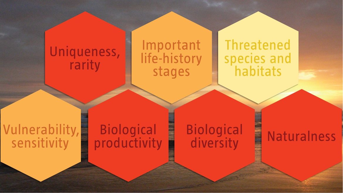
C1: Uniqueness or rarity High
Justification
Regional delineation of seamounts and canyons in the Benguela Current Large Marine Ecosystem revealed that these are rare features that likely also support rare and/or unique biological communities. The canyons and seamounts in this particular EBSA are especially rare in the region given their close proximity to the coast, whereas most other features like these are located much further offshore (Holness et al., 2014).
C2: Special importance for life-history stages of species Medium
Justification
Seamounts are known to be associated with relatively high productivity from upwelling, and that they consequently serve as foraging and aggregation areas for many top predators, and other threatened vertebrates, such as turtles. They may also provide important “stepping stones” that allow species to expand their ranges.
The benthic ecosystem types support dead organic matter originating from the ocean surface and is a habitat for some species of shrimp, crabs and lobsters. Available data suggests that benthic organisms are abundant with a uniform distribution in regions shallower than -400 m, but are rare and irregularly distributed in deeper waters. A common species is the Sipunculid, Onchnesoma steenstrupi. This species is found largely distributed in water depths ranging from subtidal shallow (<10m) to deep sea (1500m) and occurs in the Northeast Atlantic, Mediterranean Sea, and Gulf of Florida and has also been seen at depths of 1200m along the coast of Nigeria (ARC, 2013).
C3: Importance for threatened, endangered or declining species and/or habitats Low
Justification
Of the 24 ecosystem types in the proposed EBSA, only one is threatened: the Endangered Namibe Exposed Rocky Shore. The species diversity is not well known for the area. Although the site is likely to provide habitat that supports threatened species, e.g., turtles, cetaceans, birds and some fish (e.g., Vulnerable Sardinella maderensis), this criterion is conservatively ranked Low until more information is available.
C4: Vulnerability, fragility, sensitivity, or slow recovery Medium
Justification
The biological communities in Bentiaba have not been comprehensively sampled. However, it is well established that seamounts serve as an important habitat for fragile species that are sensitive to disturbance and take long to recover, including corals and sponges. Conservatively, therefore, this area is ranked as Medium, but may very well be High.
C5: Biological productivity High
Justification
Seasonal upwelling plays a crucial ecological role in the area as it results in a substantial increase in primary production that is of great importance for supporting fish stocks and influencing their distribution. Phytoplankton production rates in the area near the Angola-Benguela Front (>400 gC.m-2.yr-1) are higher compared to that in northern Angola (<250 gC.m-2.yr-1) but much lower than the estimated production rate of >1 000 gC.m-2.yr-1 further South in the Benguela Current system (ARC, 2013).
C6: Biological diversity High
Justification
The proposed EBSA comprises a particularly diverse collection of 24 habitats that range from intertidal to abyssal types (Holness et al., 2014). In turn, these are expected to support a rich diversity of species within this discrete geographic area, with known representation of numerous invertebrate phyla, as well as vertebrates such as whales, dolphins, seals, birds, turtles, and diverse assemblages of commercially important fish species including both large and small pelagics.
C7: Naturalness High
Justification
An assessment of ecological condition based on cumulative pressures within the EBSA showed that 85 % of the benthic area is in good ecological condition, and 14 % is in fair ecological condition; 60% of the pelagic area is in Good condition and 39 % is in Fair condition (Holness et al., 2014). This suggests that most of the EBSA area is highly natural.