Introduction | Status Assessment | Proposed Zoning and Management Recommendations
Interactive Map
View the Status Assessment and Proposed Zoning and Management Recommendations per EBSA
Introduction
EBSA inclusion into the upcoming Marine Spatial Planning (MSP) process is given as a proposed EBSA zoning with management recommendations per zone. Note that the current process (through the MARISMA Project) is scientific and technical, aimed at developing a coherent and evidence-based recommendation, and does not - in itself - make any ocean-zoning decisions. The actual decisions are part of the upcoming MSP process. Although the details of the MSP process have not yet been decided, it is required to include robust stakeholder engagement and negotiations among sectors. It is likely that the final negotiated Marine Spatial Plan will include significant compromises among all sectors.
EBSAs have now be fully integrated into South Africa's National Coastal and Marine Spatial Biodiversity Plan, where proposed biodiversity zones and management recommendations have been provided for the whole of the mainland maritime domain, not only for EBSAs.
Click here to submit feedback on the revised proposed recommendations for EBSA inclusion into the upcoming Marine Spatial Planning process. Before submitting feedback, it is recommended that the content below is read first. [Note: commenting period is over].
To watch a 5 min video on what MSP is, click here (video available in Afrikaans, English, isiXhosa and isiZulu), or visit South Africa's MSP website.
To develop the evidence-based recommendations for EBSA management, EBSA threat status is assessed in terms of the pressures and threats to their key biodiversity features (based on data from the recent National Biodiversity Assessment 2018 for the Marine Realm). These are the features that must remain intact to ensure that coastal and marine biodiversity and ecological processes persist into the future and, ultimately, contribute to sustainable ocean use. In order to safeguard these key biodiversity features, EBSAs or parts of EBSAs may require enhanced risk aversion, achieved by more strongly regulating human activities in specific zones.
[Top]
Background
In the MSP process, EBSAs (and other biodiversity priority areas) will likely comprise two zones, with the first zone split into three types:
|
Strict Biodiversity Conservation Zone: Marine Protected Area |
Managed according to their gazetted regulations and therefore not included in these management recommendations.
|
|
Strict Biodiversity Conservation Zone: Biodiversity Conservation Area |
The management objective is strict place-based biodiversity protection aimed at securing key biodiversity features in a natural or near-natural state, or as near to this state as possible
|
|
Strict Biodiversity Conservation Zone: Biodiversity Restoration Area |
The management objective is to improve ecological condition and, in the long term, restore to a natural / near-natural state, or as near to that state as possible. As a minimum, avoid further deterioration in ecological condition and maintain options for future restoration. |
|
Biodiversity Impact Management Zone |
The management objective is management of impacts on key biodiversity features in a mixed-use area to keep key biodiversity features in at least a functional state. |
Activities within these two zones can be placed into one of four different MSP categories depending on their compatibility with the EBSA features and management objective of that zone.
|
Primary |
An activity that supports the maintenance of biodiversity features. This activity should be encouraged in this zone, and should be prioritized when spatial management decisions are being made. These activities are still likely to be subject to reasonable controls and management measures.
|
|
General |
An activity that is allowed and regulated by current general rules and legislation.
|
|
Consent |
An activity which can continue in this zone subject to specific regulation and control. Careful controls are likely to be put in place to avoid unacceptable impacts on biodiversity features, or ideally to avoid intensification or expansion of impact footprints of uses that are already occuring and where there are no realistic prospects of excluding these activities.
|
|
Prohibited |
An activity which is not allowed or should not be allowed because it is incompatible with maintaining the biodiversity objectives of the zone. |
As noted above, decisions about the management of each activity within an EBSA will be negotiated during the MSP process, which is mandated to include a robust stakeholder process. The MARISMA Project is undertaking initial assessments of activity compatibility with the zone management objectives to provide a coherent recommendation from the biodiversity sector that addresses as many initial concerns from other sectors as possible to streamline the negotiations during the MSP process. Again, the recommendations are not the final ocean-zoning decisions, but rather form the biodiversity sector’s input into the multi-sector process that will be negotiated during MSP.
[Top]
Proposed EBSA Zoning
Identifying the EBSA zones and activities compatible within them has been discussed at two National Workshops (see sidebar for meeting minutes), and through the development of the National Coastal and Marine Spatial Biodiversity Plan.The zones are based on the Map of Critical Biodiversity Areas (CBA Map) from the National Coastal and Marine Spatial Biodiversity Plan Version 1.2. This CBA Map is based on a systematic biodiversity plan, where the EBSA Strict Biodiversity Conservation Zone: Biodiversity Conservation Areas is equivalent to Critical Biodiversity Areas (Natural), the EBSA Strict Biodiversity Conservation Zone: Biodiversity Restoration Areas is equivalent to the Critical Biodiversity Areas (Restore), and the EBSA Biodiversity Impact Management Zone is equivalent to Ecological Support Areas because the management objectives match in all cases.
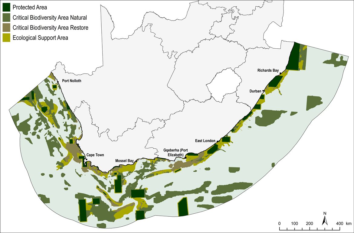
National Coastal and Marine CBA Map v1.2 (Released 04-12-2022)
The EBSA Zone boundaries were subject to ongoing revision based on discussions with the National EBSA Working Group. They are fully incorporated into the national Coastal and Marine CBA Map so that there is a single, coherent input from the biodiversity sector in multi-sector processes such as MSP. Note that the MSP negotiations will likely modify these zones even further if compromises are made between sectors.
[Top]
Proposed management recommendations
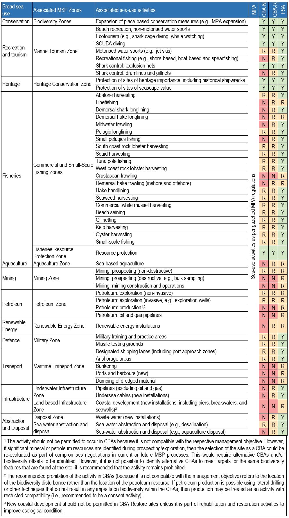
To support the biodiversity sector’s recommendations, activities are evaluated here according to their compatibility with the management objective of the EBSA zones. Activities can be compatible (i.e., where current general rules and legislation would be appropriate to manage these activities within an EBSA), restricted compatibility (i.e., compatible in some cases, and generally only if stricter regulations and controls are applied over and above those stipulated in current general rules and legislation), or not compatible (i.e., where the activity is not compatible with the management objective). If an activity that is not compatible with an EBSA zone is permitted as part of compromises in MSP negotiations, it would require alternative areas or offsets to be identified. However, if this is not possible, it is recommended that the activity is prohibited within the EBSA zone. The principles tabulated below for assessing activity compatibility with the EBSA zones/CBA Map categories were based on the National Biodiversity Assessment 2018 Marine Realm Report, specifically the ecosystem-pressure matrix (Chapter 7).
Principles for assessing compatibility of activities within the EBSA Biodiversity Conservation Zone and Environmental Impact Management Zone, and implications for management of those activities
The table of compatibility of activities with EBSA zones (below) is from the sea-use guidelines presented in the National Coastal and Marine Spatial Biodiversity Plan Version 1.2. Note that this table sets out the absolute minimum recommendations for management of activities. They do not override existing controls on an activity (e.g., gillnetting) or where prohibitions are already in place (e.g., ammunition dumping). Further, the ideal position is if improved place-based protection of EBSA features is pursued. This may require additional Marine Protected Area declaration/expansion and/or other effective conservation measures in the Strict Biodiversity Conservation Zone: Biodiversity Conservation Areas and Strict Biodiversity Conservation Zone: Biodiversity Restoration Areas.
List of all sea-use activities, grouped by their Marine Spatial Planning (MSP) zones, and scored according to their compatibility with the management objective of the Biodiversity Conservation Zone (i.e., Critical Biodiversity Area Natural, CBA-N), Biodiversity Restoration Zone (i.e., Critical Biodiversity Area Restore, CBA-R) and Biodiversity Impact Management Zone (i.e., Ecological Support Area, ESA). Activity compatibility is given as Y = yes, compatible, R = restricted compatibility, or N = not compatible. (Sea-use guidelines Version 1.2)
[Top]
Interactive Map
[Note: this was an earlier iteration of the EBSA zonation that was proposed. It has since been updated in the CBA Map Version 1.2. Those interested in viewing the EBSA zones in more detail can download the shapefile of the CBA Map V1.2.]
Zoom in to view the revised recommendations for inclusion of South African EBSAs into the upcoming Marine Spatial Planning process. Note that the proposed zonation and recommended management in transboundary EBSAs is split at the national borders, with each country responsible for EBSA management in their own jurisdiction only. Proposed Conservation Zones are given in green; proposed Impact Management Zones are given in yellow. MPA boundaries are outlined in orange. The management recommendations for each EBSA zone are the same as the sea-use guidelines in the table above, with the main activities that are currently present in the EBSA highlighted for ease of reference. These can be accessed by clicking on each EBSA zone, or by viewing the individual EBSA status assessment and management recommendations pages below. It is recommended to view the interactive map full screen.
If you would like to provide feedback on the revised proposed zoning and management recommendations for EBSAs in South Africa, click here to fill in the survey form. [Note: the commenting period is now closed].
These documents provide the initial position on EBSA zoning, and have been updated to include the latest zoning and management recommendations based on the national Coastal and Marine CBA Map V1.2.
Orange Seamount and Canyon Complex | Orange Cone | Namaqua Fossil Forest
Childs Bank and Shelf Edge | Namaqua Coastal Area | Cape Canyon & Associated Islands, Bays & Lagoon
Seas of Good Hope | Protea Seamount Cluster | Browns Bank | Mallory Escarpment and Trough
Shackleton Seamount Complex | Agulhas Bank Nursery Area | Tsitsikamma-Robberg
Kingklip Corals | Algoa to Amathole | Protea Banks and Sardine Route
KwaZulu-Natal Bight and uThukela River | Delagoa Shelf Edge, Canyons and Slope
[Top]