EBSA Status Assessment and Management Recommendations
Ecological Condition, Threat Status, Current Protection and Key Features in the EBSA
Relevant Pressures and Activities (impact, extent) | Management Interventions Needed for the EBSA
Activity Evaluation Per Zone: Zoning Feasibility | Research Needs & Future Process
Back to the Angolan EBSA status and management home page
Longa Coastline comprises a mostly undisturbed, high-energy marine system, with a very well protected lagoon formed at the Longa River mouth behind a sand dune cordon. It supports species that are slow growing and vulnerable to disturbance, some of which are threatened, including mangroves, olive ridley turtles, and birds. The lagoon plays and important role in many ecological processes.
Click here for the full EBSA description
[Top]
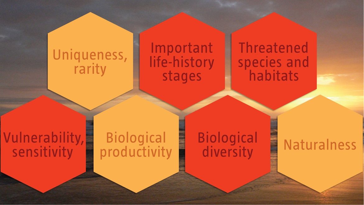
Longa Coastline has multiple ecological features and ecosystem types that need to be protected for the area to maintain the characteristics that give it its EBSA status. The criteria for which this EBSA ranks highly are: importance for life-history stages; importance for threatened species and habitats, vulnerability and sensitivity, and biological diversity. Seven ecosystem types are represented in the EBSA, five of which are threatened. The lagoon at the Longa River mouth is an important feature, underpinning many of the features for which the EBSA is described. It is an understudied system and needs more research to understand its biodiversity patterns, processes, and ecological role, which could benefit from traditional knowledge held by members of the local communities. The EBSA also includes some important mangroves, has a particularly rich diversity of plants, birds, mammals, reptiles, fish and invertebrates from the terrestrial, estuarine and marine realms, and provides critical habitat for Vulnerable manatees (which are facing local extirpations) and Vulnerable nesting turtles.
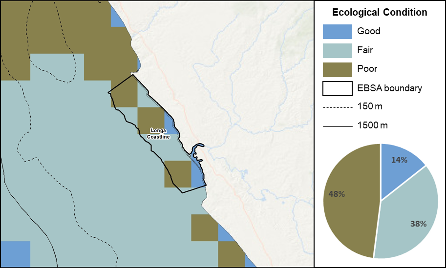
Longa Coastline proportion of area in each ecological condition category.
Longa Coastline is in good (22%) to fair ecological condition (78%). However, four of the seven ecosystem types within the EBSA are Endangered, comprising 91% of the EBSA. Only 6% of the area comprises ecosystem types that are Least Concern, which includes portions of rocky and sandy shores. Further, the ecosystem type forming the majority of the lagoon is listed as Vulnerable, comprising 1% of the EBSA. A small portion of the EBSA was not assessed (2%), and is largely composed of mangrove forests surrounding the lagoon.
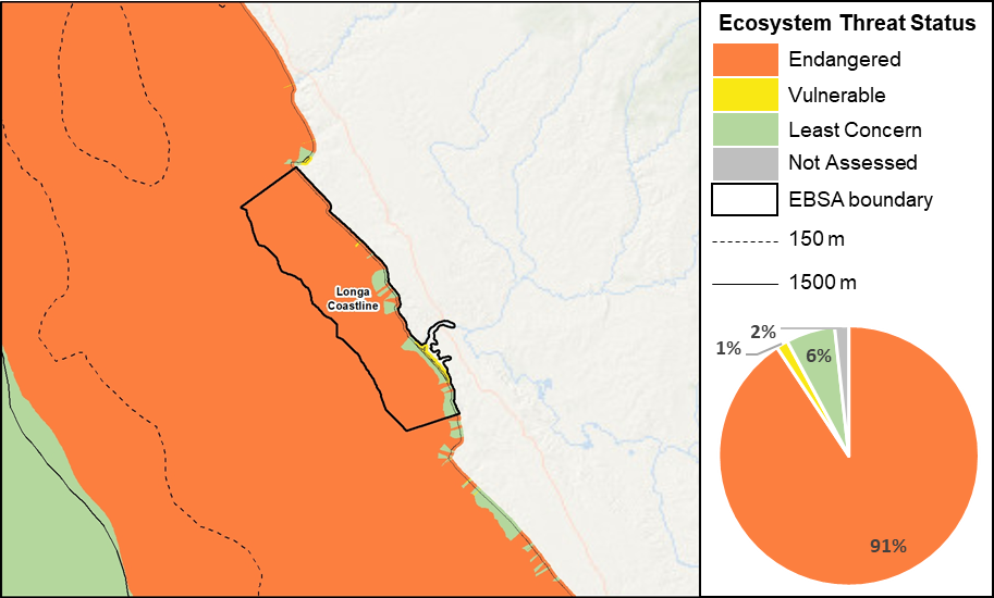
Longa Coastline proportion of area in each ecosystem threat status category.
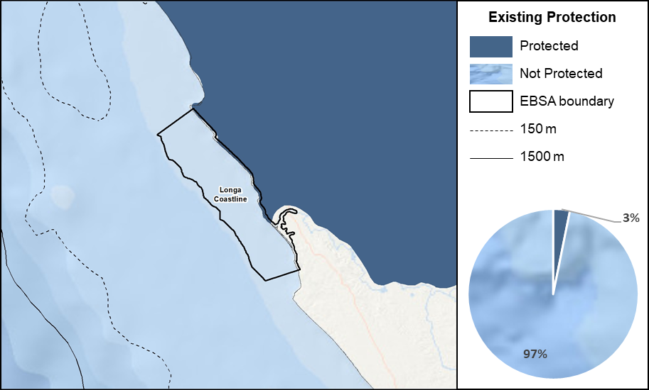
Longa Coastline proportion of area in a Marine Protected Area (MPA).
Currently, there are no Marine Protected Areas that overlap with the EBSA to protect its features and processes, although it is partially adjacent to the Quiçama National Park. This Park offers some protection (3%) to the proposed EBSA; however, most ecosystem types are Not Protected or Poorly Protected, and two are Moderately Protected.
Threat status, protection level and ecological condition of ecosystem types in the EBSA. Other key features are also listed.
|
Feature
|
Threat Status
|
Protection Level
|
Condition (%)
|
|
Good
|
Fair
|
Poor
|
|
Ecosystem Types
|
|
Kwanza Estuarine Shore
|
VU
|
PP
|
67.63
|
27.77
|
4.60
|
|
Kwanza Exposed Rocky Shore
|
EN
|
PP
|
0.00
|
100.00
|
0.00
|
|
Kwanza Inshore
|
EN
|
NP
|
6.42
|
37.17
|
56.41
|
|
Kwanza Intermediate Sandy Beach
|
EN
|
MP
|
37.31
|
2.26
|
60.43
|
|
Kwanza Mixed Shore
|
EN
|
MP
|
20.18
|
55.95
|
23.87
|
|
Kwanza Reflective Sandy Beach
|
LC
|
PP
|
53.97
|
45.35
|
0.68
|
|
Kwanza Sheltered Rocky Shore
|
LC
|
PP
|
82.80
|
17.18
|
0.01
|
|
Other Features
|
-
Lagoon
-
Nesting olive ridley turtles
-
Rich diversity, including many species of birds
-
Mangroves
-
Manatees (historically; current presence unknown)
|
[Top]
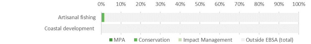
-
There are two pressures that are present in the EBSA: artisanal fishing and coastal development. For these pressures, the larger portion of the activity is in the proposed Conservation Zone.
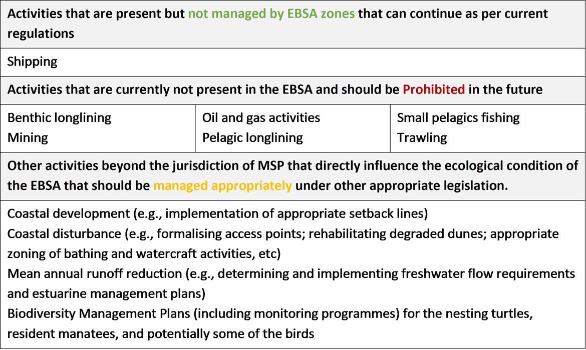
-
Activities that are not present in this EBSA include: benthic longlining, pelagic longlining, shipping, trawling, mining, small pelagics fishing and oil and gas activities.
-
Note that the data of individual pressures used in the assessment were from global datasets, some of which were mapped at a coarser resolution than is displayed below (i.e., shipping and oil and gas). The finer scale data are included to facilitate more accurate management recommendations. The fine-scale fishing data indicate fishing activity within the EBSA. It will need to be confirmed with the various industries whether this is commercial fishing, and if so, which industry because it will have implications for the management recommendations for those industries.
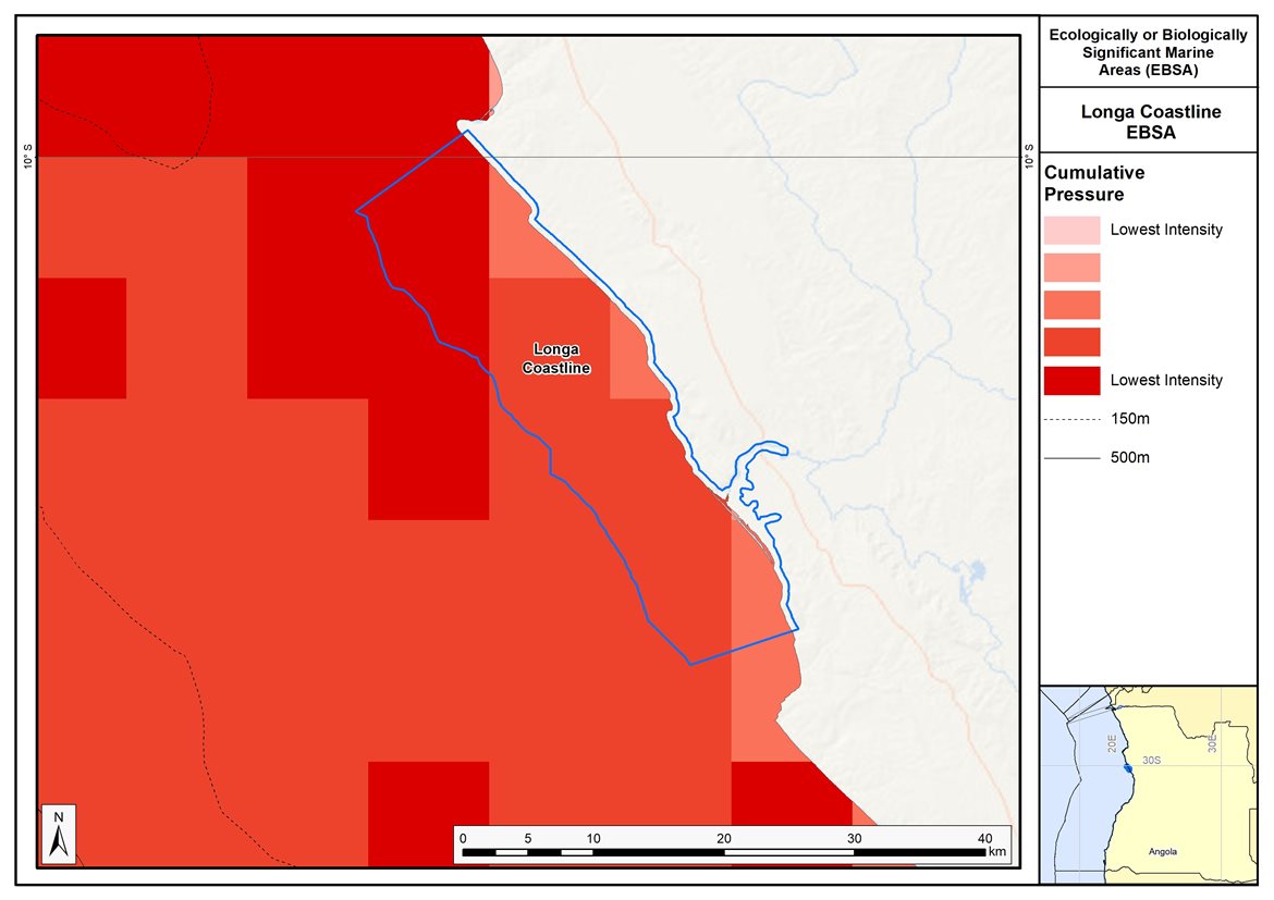
Map of cumulative pressure from all activities in the EBSA and surrounds. Darker reds indicate higher pressure intensity.
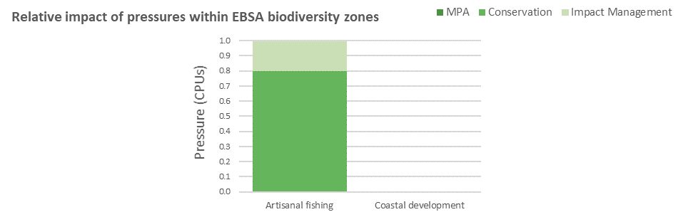
Pressure (in arbitrary cumulative pressure units, CPUs) summed for each pressure in the EBSA, per proposed EBSA biodiversity zone, ranked left (highest) to right (lowest) by the overall relative importance of pressures in this EBSA. Note that coastal development comprises <1% of the EBSA pressure profile.
[Top]
Improved place-based protection of EBSA features should be pursued. In support of this, the EBSA is divided into a Conservation Zone and an Impact Management Zone, both comprising several areas within the EBSA. The aim of the Conservation Zone is to secure core areas of key biodiversity features in natural / near-natural ecological condition. Strict place-based biodiversity conservation is thus directed at securing key biodiversity features in a natural or semi-natural state, or as near to this state as possible. Activities or uses that have significant biodiversity impacts should be prohibited. Where possible and appropriate these areas should be considered for formal protection e.g., Marine Protected Areas or other effective area-based conservation measures (OECM). The aim of the Impact Management Zone is to manage negative impacts on key biodiversity features where strict place-based measures are not practical or not essential. In this zone, the focus is management of impacts on key biodiversity features in a mixed-use area, with the objective to keep biodiversity features in at least a functional state. Activities or uses which have significant biodiversity impacts should be strictly controlled and/or regulated. Within this zone, there should be no increase in the intensity of use or the extent of the footprint of activities that have significant biodiversity impacts. Where possible, biodiversity impacts should be reduced. As far as possible, the Conservation Zone was designed deliberately to avoid conflicts with existing activities. Note that there are no marine protected areas in this EBSA; however, it does lie adjacent to the Quiçama National Park, which was established in 1938.
Proposed zonation of the EBSA into Conservation (medium green) and Impact Management (light green) Zones. MPAs are overlaid in orange outlines, with the extent within the EBSA given in dark green. Click on each of the zones to view the proposed management recommendations.
[Top]
Protection of features in the rest of the Conservation Zone may require additional Marine Protected Area declaration/expansion. Other effective conservation measures should also be applied via Marine Spatial Planning to ensure that the existing activities/uses are appropriately controlled to ensure compatibility of activities with the environmental requirements for achieving the management objectives of the EBSA Conservation and Impact Management Zones. Further, no new pressures should be extended into the Conservation Zone, even if they currently occur in the Impact Management Zone of the EBSA.
Recommended compatibility (consent1 or prohibited2) of activities currently present in the EBSA3 in the Conservation and Impact Management Zones
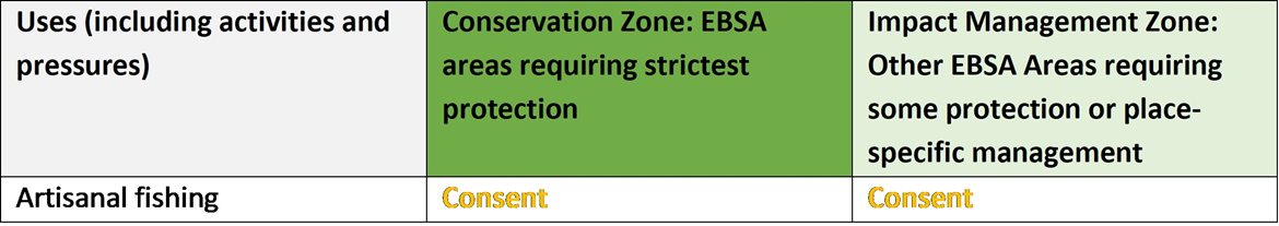
1Consent: An activity which can continue in this zone subject to specific regulation and control.
2Prohibited: An activity which is not allowed or should not be allowed because it is incompatible with maintaining the biodiversity objectives of the zone.
3Note that activities present in Angola that are not relevant to the EBSA have been excluded from the table (e.g., the harvested species does not occur in the area; or the industry operates at a depth outside the depth range of the EBSA).
Furthermore, no new activities that can negatively impact the environment should be allowed in the EBSA, and some activities present in the EBSA do not need to be managed by EBSA zoning and can continue as per the current regulations. There are also some pressures on biodiversity features within the EBSA that originate from activities outside of these EBSA or beyond the jurisdiction of MSP. In support of maintaining the ecological integrity of and benefits delivered by the key biodiversity features, these other activities need to be appropriately managed by complementary initiatives.
Recommendations for other activities outside the EBSA or the MSP management jurisdiction.
Proposed zonation of the EBSA, with the cumulative intensity footprint of activities within the EBSA (sorted highest to lowest) given relative to the national footprint of those activities to illustrate feasibility of management interventions.
Acknowledging the contribution of artisanal fishing to coastal households in the area surrounding the EBSA, this activity is accommodated in the EBSA zonation and is recommended to continue in both EBSA zones as a Consent activity. Shipping is recommended to continue under current general rules and legislation. Thus, the EBSA zonation has no or minimal impact on the national footprint for the listed marine activities.
There are also several activities that are largely outside the EBSA but have downstream impacts to the biodiversity within the EBSA, e.g., from mean annual runoff reduction, coastal development, coastal disturbance, and wastewater discharge. The impacts should be managed, but principally fall outside the direct management and zoning of the EBSA. These existing activities are proposed as Consent activities for both EBSA zones, recognising that they should ideally be dealt with in complementary integrated coastal zone management in support of the EBSA. For example, rehabilitation of degraded dunes and formalising access points could support improved habitat for nesting shorebirds, and enhanced benefits for coastal protection during storm surges. Similarly, improved estuary management through development of appropriate freshwater flow requirements, estuarine management plans and wastewater management regulations can improve the ecological condition of the surrounding marine environment, in turn, improving water quality and safe conditions for human recreation. It is also recommended that mangrove harvesting is carefully managed, and ideally prohibited in the Conservation Zone. It is also recommended to consider developing and implementing Biodiversity Management Plans for the iconic/top predator species, e.g., turtles, cetaceans and some of the seabirds and shorebirds in support of securing the biodiversity features for which the EBSA is recognised.
Research Needs
In addition to the general research needs, there is a clear need for future research on the lagoon component of this EBSA to understand its broader significance. The research required is to better understand the biodiversity patterns, ecological processes, ecological role and vulnerability of this regionally unique estuarine lagoon system. For example, what species are present; what is the importance/role of the crocodiles, birds and mangrove species; what are the dynamics of the estuary and the effects during mouth breaching or mouth closure and back flooding? Although not much is formally known about it, local insights indicate that the lagoon is an important feature. Given these local (human) communities in the surrounding area, traditional knowledge could play an important role in future research projects. For example, as noted below, it is said that local fish catches have declined in recent years: research is necessary to establish why, and how this could potentially be mitigated or reversed, and local fishers’ knowledge could be important in reconstructing past information. Research is also required to determine if manatees still exists in the area, or if they have been extirpated (and if the latter, why). Local knowledge may assist with this as well.
Future Process
Angola’s preliminary national Marine Spatial Plan (Republic of Angola, 2022a), which incorporates the outcomes of the pilot central area (Republic of Angola et al., 2019), was approved in February 2023. This effectively formalizes the EBSA conservation and impact management zones as the national biodiversity zones for the MSP. However, futher work and engagement is still required to clarify the details of the allowed uses of the zones, which will then require implementation, monitoring and management.
The Conservation areas of the EBSA are being taken forward as the core of an emerging national MPA network. A technical proposal has been prepared to support this (Republic of Angola, 2022b), which has been through government review and revision, but the stakeholder processes have not yet begun. The key steps that need to be taken for this EBSA include:
-
Initiating the required stakeholder process
-
Negotiations around final MPA boundaries
-
Refining zones and their specific sea uses and regulations
-
Formal gazetting as an MPA
-
Resourcing MPA management, management plans, and staffing
-
Monitoring and evaluating the outcomes
References
Republic of Angola, 2022a. Preliminary Proposal of the Marine Spatial Planning Plan in Angola: National Plan. Ministry of Fisheries and Sea, National Directorate for the Affairs of the Sea. Luanda, Angola.
Republic of Angola, 2019. Preliminary Proposal of the Marine Spatial Planning Plan in Angola: Palmeirinhas Pilot Area - Foz do Rio Tapado. Ministry of Fisheries and Sea, National Directorate for the Affairs of the Sea. Luanda, Angola.
Republic of Angola, 2022b. Relatório Técnico da Proposta de Área de Conservação Marinha dos Mangais da Ponta Padrão e Praias das Tartarugas no Soyo, Zaire. Ministério da Agricultura e Pescas. Luanda, Angola.
[Top]