EBSA Status Assessment and Management Recommendations
Ecological Condition, Threat Status, Current Protection and Key Features in the EBSA
Relevant Pressures and Activities (impact, extent) | Management Interventions Needed for the EBSA
Activity Evaluation Per Zone: Zoning Feasibility | Research Needs & Future Process
Back to the Angolan EBSA status and management home page

Chiloango Mangroves includes the mangroves and riverine forest around the Chiloango Estuary, and the adjacent coast. It is important for breeding, resting and/or feeding for threatened turtles, manatees and birds. These animals and mangrove trees are vulnerable to disturbance because they take so long to recover once impacted. It also includes four threatened ecosystem types and is a key nursery area for fish and crustaceans.
Click here for the full EBSA description
[Top]
Chiloango Mangroves is a coastal EBSA that has many features and ecosystem types that need to be protected for the area to maintain the characteristics that give it its EBSA status. The criteria for which this EBSA ranks highly are: importance for life history stages, importance for threatened species and habitats, vulnerability and sensitivity, and biological diversity. It includes five ecosystem types of shores and inner shelf, four of which are threatened. The mangrove forest is the second largest in the country, and together with the associated riverine forest, are key features that underpin the criteria for which the EBSA is described.
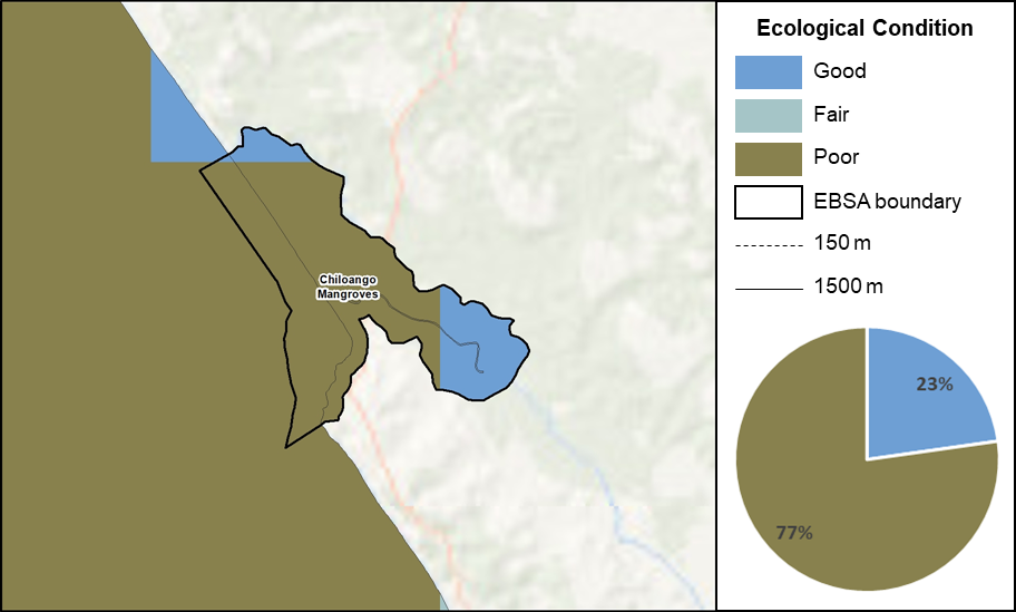
Chiloango Mangroves proportion of area in each ecological condition category.
Chiloango Mangroves is in good (23%) to fair ecological condition (77%), which is in a much more natural state compared to much of the marine area surrounding the EBSA that is in poor ecological condition. Three ecosystem types are Endangered, and one is Vulnerable, jointly comprising 41% of the EBSA. The remainder comprises one ecosystem type of Least Concern (18% of the EBSA), and other ecosystem types that were not assessed (41% of the EBSA extent). All of the ecosystem types are Not Protected. This means that the EBSA currently encompasses a portion of threatened and Not Protected ecosystem types in a place where they are exposed to fewer pressures and are still relatively natural (good to fair ecological condition), consequently representing a site of high priority for protection. Currently, there are no Marine Protected Areas that overlap with the EBSA to protect its features and processes.
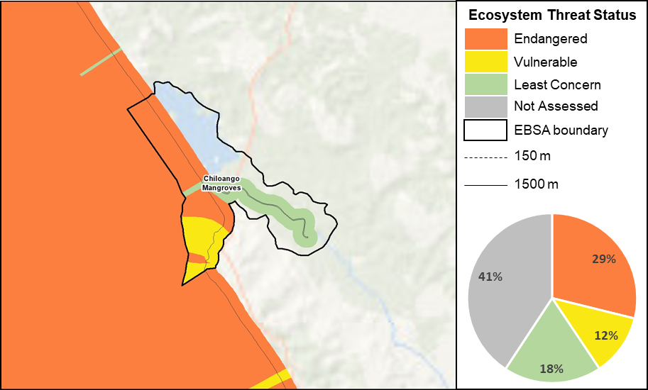
Chiloango Mangroves proportion of area in each ecosystem threat status category.
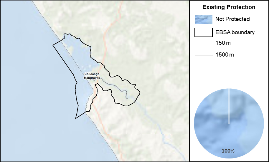
Chiloango Mangroves proportion of area in a Marine Protected Area (MPA).
Threat status, protection level and ecological condition of ecosystem types in the EBSA. Other key features are also listed.
|
Feature
|
Threat Status
|
Protection Level
|
Condition (%)
|
|
Good
|
Fair
|
Poor
|
|
Ecosystem Types
|
|
Cabinda Estuarine Shore
|
LC
|
NP
|
38.79
|
0.00
|
61.21
|
|
Cabinda Inshore
|
EN
|
NP
|
0.00
|
0.00
|
100.00
|
|
Cabinda Mixed Shore
|
VU
|
NP
|
0.00
|
0.00
|
100.00
|
|
Cabinda Reflective Sandy Beach
|
EN
|
NP
|
2.94
|
0.00
|
97.06
|
|
Cabinda Sheltered Rocky Shore
|
EN
|
NP
|
0.00
|
0.00
|
100.00
|
|
Other Features
|
-
Leatherback turtles
-
Olive Ridley turtles
-
Manatees
-
Second largest mangrove forest in the country that provide nursery functions for fish
-
Migratory birds
-
Rich terrestrial biodiversity in the riverine forest
|
[Top]
-
There are two pressures that are present in the EBSA: artisanal fishing and coastal development. For these pressures, the larger portion of the activity is in the proposed Conservation Zone.
-
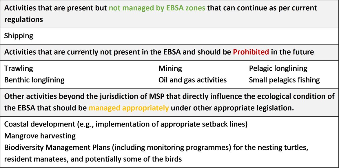
Activities that are not present in this EBSA include: benthic longlining, pelagic longlining, shipping, trawling, mining, small pelagics fishing and oil and gas activities.
-
Note that the data of individual pressures used in the assessment were from global datasets, some of which were mapped at a coarser resolution than is displayed below (i.e., shipping and oil and gas activities). The finer scale data are included to facilitate more accurate management recommendations.
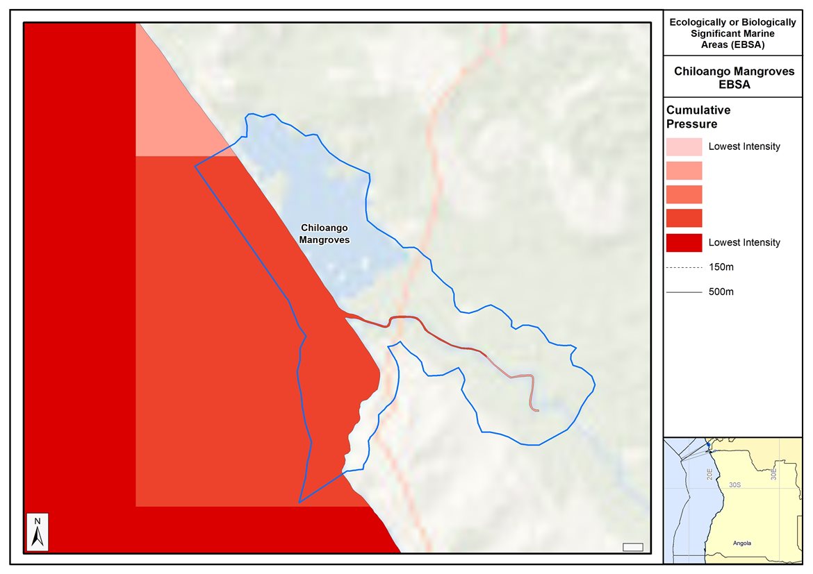
Map of cumulative pressure from all activities in the EBSA and surrounds. Darker reds indicate higher pressure intensity.
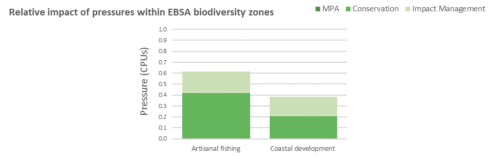
Pressure (in arbitrary cumulative pressure units, CPUs) summed for each pressure in the EBSA, per proposed EBSA biodiversity zone, ranked left (highest) to right (lowest) by the overall relative importance of pressures in this EBSA.
[Top]
Improved place-based protection of EBSA features should be pursued. In support of this, the EBSA is divided into a Conservation Zone and an Impact Management Zone, both comprising several areas within the EBSA. The aim of the Conservation Zone is to secure core areas of key biodiversity features in natural / near-natural ecological condition. Strict place-based biodiversity conservation is thus directed at securing key biodiversity features in a natural or semi-natural state, or as near to this state as possible. Activities or uses that have significant biodiversity impacts should be prohibited. Where possible and appropriate these areas should be considered for formal protection e.g., Marine Protected Areas or other effective area-based conservation measures (OECM). The aim of the Impact Management Zone is to manage negative impacts on key biodiversity features where strict place-based measures are not practical or not essential. In this zone, the focus is management of impacts on key biodiversity features in a mixed-use area, with the objective to keep biodiversity features in at least a functional state. Activities or uses which have significant biodiversity impacts should be strictly controlled and/or regulated. Within this zone, there should be no increase in the intensity of use or the extent of the footprint of activities that have significant biodiversity impacts. Where possible, biodiversity impacts should be reduced. As far as possible, the Conservation Zone was designed deliberately to avoid conflicts with existing activities. Note that there are no marine protected areas in this EBSA.
Proposed zonation of the EBSA into Conservation (medium green) and Impact Management (light green) Zones. MPAs are overlaid in orange outlines, with the extent within the EBSA given in dark green. Click on each of the zones to view the proposed management recommendations.
[Top]
Protection of features in the rest of the Conservation Zone may require additional Marine Protected Area declaration/expansion. Other effective conservation measures should also be applied via Marine Spatial Planning to ensure that the existing activities/uses are appropriately controlled to ensure compatibility of activities with the environmental requirements for achieving the management objectives of the EBSA Conservation and Impact Management Zones. Further, no new pressures should be extended into the Conservation Zone, even if they currently occur in the Impact Management Zone of the EBSA.
Recommended compatibility (consent1 or prohibited2) of activities currently present in the EBSA3 in the Conservation and Impact Management Zones
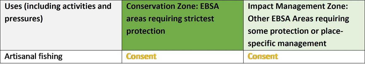
1Consent: An activity which can continue in this zone subject to specific regulation and control.
2Prohibited: An activity which is not allowed or should not be allowed because it is incompatible with maintaining the biodiversity objectives of the zone.
3Note that activities present in Angola that are not relevant to the EBSA have been excluded from the table (e.g., the harvested species does not occur in the area; or the industry operates at a depth outside the depth range of the EBSA).
Furthermore, no new activities that can negatively impact the environment should be allowed in the EBSA, and some activities present in the EBSA do not need to be managed by EBSA zoning and can continue as per the current regulations. There are also some pressures on biodiversity features within the EBSA that originate from activities outside of these EBSA or beyond the jurisdiction of MSP. In support of maintaining the ecological integrity of and benefits delivered by the key biodiversity features, these other activities need to be appropriately managed by complementary initiatives.
Recommendations for other activities outside the EBSA or the MSP management jurisdiction.
Activity Evaluation Per Zone: Zoning Feasibility
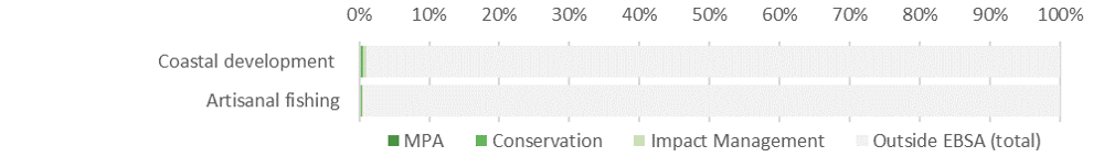
Proposed zonation of the EBSA, with the cumulative intensity footprint of activities within the EBSA (sorted highest to lowest) given relative to the national footprint of those activities to illustrate feasibility of management interventions.
Acknowledging the contribution of artisanal fishing to coastal households in the area surrounding the EBSA, this activity is accommodated in the EBSA zonation and is recommended to continue in both EBSA zones as a Consent activity. Shipping is recommended to continue under current general rules and legislation. Thus, the EBSA zonation has no or minimal impact on the national footprint for the listed marine activities.
There are also several activities that are largely outside the EBSA but have downstream impacts to the biodiversity within the EBSA, e.g., from coastal development and mangrove harvesting. The impacts should be managed, but principally fall outside the direct management and zoning of the EBSA. Recognising that they should ideally be dealt with in complementary integrated coastal zone management in support of the EBSA, it is recommended that no further coastal development is constructed within the Conservation Zone, and constructed conservatively in the Impact Management Zone. It is also recommended that mangrove harvesting is carefully managed, and ideally prohibited in the Conservation Zone. It is also recommended to consider developing and implementing Biodiversity Management Plans for the iconic/top predator species, e.g., turtles, cetaceans and some of the seabirds and shorebirds in support of securing the biodiversity features for which the EBSA is recognised.
Research Needs
There are no specific research needs for this EBSA in addition to those for all EBSAs.
Future Process
Angola’s preliminary national Marine Spatial Plan (Republic of Angola, 2022a), which incorporates the outcomes of the pilot central area (Republic of Angola, 2019), was approved in February 2023. This effectively formalizes the EBSA conservation and impact management zones as the national biodiversity zones for the MSP. However, futher work and engagement is still required to clarify the details of the allowed uses of the zones, which will then require implementation, monitoring and management.
The Conservation areas of the EBSA are being taken forward as the core of an emerging national MPA network. A technical proposal has been prepared to support this (Republic of Angola, 2022b), which has been through government review and revision, but the stakeholder processes have not yet begun. The key steps that need to be taken for this EBSA include:
-
Initiating the required stakeholder process
-
Negotiations around final MPA boundaries
-
Refining zones and their specific sea uses and regulations
-
Formal gazetting as an MPA
-
Resourcing MPA management, management plans, and staffing
-
Monitoring and evaluating the outcomes
References
Republic of Angola, 2022a. Preliminary Proposal of the Marine Spatial Planning Plan in Angola: National Plan. Ministry of Fisheries and Sea, National Directorate for the Affairs of the Sea. Luanda, Angola.
Republic of Angola, 2019. Preliminary Proposal of the Marine Spatial Planning Plan in Angola: Palmeirinhas Pilot Area - Foz do Rio Tapado. Ministry of Fisheries and Sea, National Directorate for the Affairs of the Sea. Luanda, Angola.
Republic of Angola, 2022b. Relatório Técnico da Proposta de Área de Conservação Marinha dos Mangais do Chiloango em Cabinda. Ministério da Agricultura e Pescas. Luanda, Angola.
[Top]