EBSA Status Assessment and Management Recommendations
Ecological Condition, Threat Status, Current Protection and Key Features in the EBSA
Relevant Pressures and Activities (impact, extent) | Management Interventions Needed for the EBSA
Activity Evaluation Per Zone: Zoning Feasibility | Research Needs & Future Process
Back to the Namibian EBSA status and management home page
Namibian Islands comprises key islands and adjacent coastal habitat that provide key breeding and foraging areas for a number of threatened top predators, especially African penguins, cormorants and Cape gannets. It is situated in the Lüderitz Upwelling Cell, so productivity is high, also supporting foraging turtles and cetaceans, although historically depleted fish stocks are still recovering. It is entirely within in the Namibian Islands MPA.
Click here for the full EBSA description
[Top]
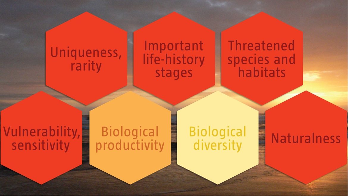
Namibian Islands has many features and ecosystem types that need to be protected for the area to maintain the characteristics that give it its EBSA status. The criteria for which this EBSA ranks highly are: uniqueness and rarity; importance for life-history stages; importance for threatened species and habitats; vulnerability and sensitivity; and naturalness. There are 27 ecosystem types represented, six of which are threatened, including two Critically Endangered types: Namaqua Intermediate Sandy Beach and Namaqua Reflective Sandy Beach; one Endangered type: Kuiseb Mixed Shore and three Vulnerable types. Productivity is particularly high in this area because it is within the intensive Lüderitz Upwelling Cell. The islands are crucial seabird breeding sites within the existing Namibian Islands Marine Protected Area (NIMPA). The surrounding waters are also key foraging grounds for these seabirds for both the adults and as they provide for their chicks, and for Critically Endangered leatherbacks from the Western Indian Ocean that nest in South Africa.
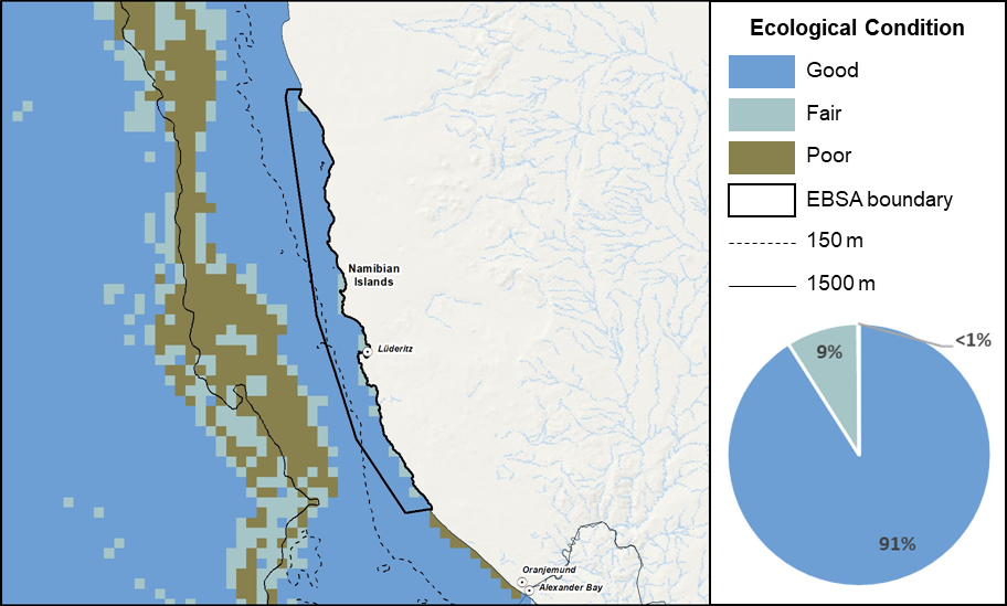
Namibian Islands proportion of area in each ecological condition category.
Namibian Islands is largely in good ecological condition (96%), with only 4% in fair ecological condition, largely as a result of the protection afforded by NIMPA. Consequently, 21 of the 27 ecosystem types within the area are Least Concern, comprising 92% of the EBSA extent. The three Vulnerable ecosystem types (Lüderitz Outer Shelf, Namaqua Exposed Rocky Shore, and Namaqua Inshore) comprise 8% of the EBSA extent, with the Endangered Kuiseb Mixed Shore and Critically Endangered Namaqua Intermediate Sandy Beach and Namaqua Reflective Sandy Beach comprising <2% of the EBSA.
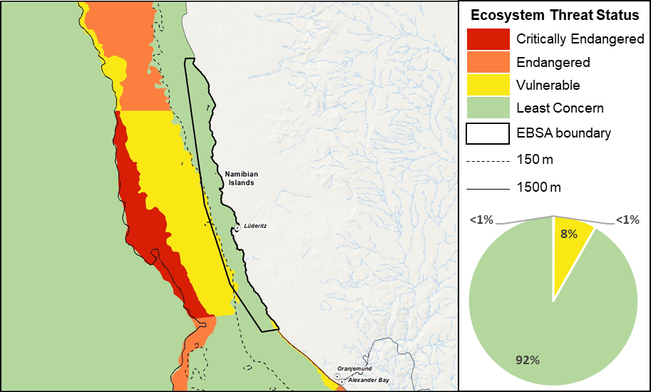
Namibian Islands proportion of area in each ecosystem threat status category.
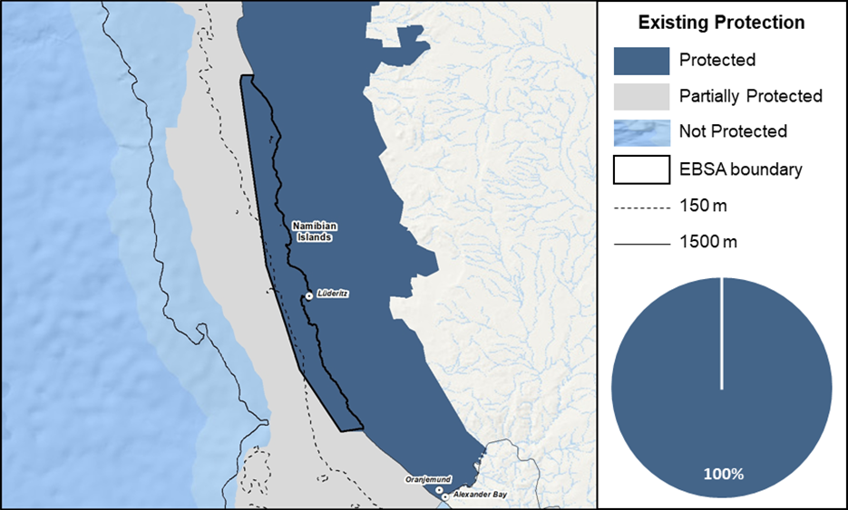
Namibian Islands proportion of area in a Marine Protected Area (MPA).
The delineation of Namibian Islands matches that of NIMPA, such that 100 of the EBSA is protected. The adjacent terrestrial area is also protected in the Sperrgebiet and Namib-Naukluft National Parks. Consequently, 24 of the 27 ecosystem types are Well Protected, and the other three are Moderately Protected.
Threat status, protection level and ecological condition of ecosystem types in the EBSA. Other key features are also listed.
|
Feature
|
Threat Status
|
Protection Level
|
Condition (%)
|
|
Good
|
Fair
|
Poor
|
|
Ecosystem Types
|
|
Central Namib Inner Shelf
|
LC
|
MP
|
100.00
|
0.00
|
0.00
|
|
Kuiseb Dissipative-Intermediate Sandy Beach
|
LC
|
WP
|
100.00
|
0.00
|
0.00
|
|
Kuiseb Exposed Rocky Shore
|
LC
|
WP
|
100.00
|
0.00
|
0.00
|
|
Kuiseb Inshore
|
LC
|
WP
|
90.03
|
9.97
|
0.00
|
|
Kuiseb Intermediate Sandy Beach
|
LC
|
WP
|
85.32
|
14.68
|
0.00
|
|
Kuiseb Mixed Shore
|
EN
|
WP
|
100.00
|
0.00
|
0.00
|
|
Kuiseb Reflective Sandy Beach
|
LC
|
WP
|
100.00
|
0.00
|
0.00
|
|
Lüderitz Dissipative Sandy Beach
|
LC
|
WP
|
46.98
|
53.02
|
0.00
|
|
Lüderitz Dissipative-Intermediate Sandy Beach
|
LC
|
WP
|
80.82
|
19.18
|
0.00
|
|
Lüderitz Exposed Rocky Shore
|
LC
|
WP
|
69.14
|
30.86
|
0.00
|
|
Lüderitz Inner Shelf
|
LC
|
WP
|
96.58
|
3.42
|
0.00
|
|
Lüderitz Inshore
|
LC
|
WP
|
72.39
|
27.61
|
0.00
|
|
Lüderitz Intermediate Sandy Beach
|
LC
|
WP
|
62.82
|
36.36
|
0.82
|
|
Lüderitz Island
|
LC
|
WP
|
70.66
|
29.17
|
0.18
|
|
Lüderitz Lagoon Coast
|
LC
|
WP
|
0.00
|
100.00
|
0.00
|
|
Lüderitz Mixed Shore
|
LC
|
WP
|
60.92
|
35.98
|
3.10
|
|
Lüderitz Outer Shelf
|
VU
|
MP
|
100.00
|
0.00
|
0.00
|
|
Lüderitz Reflective Sandy Beach
|
LC
|
WP
|
52.56
|
47.44
|
0.00
|
|
Lüderitz Sheltered Rocky Shore
|
LC
|
WP
|
22.94
|
72.26
|
4.80
|
|
Lüderitz Very Exposed Rocky Shore
|
LC
|
WP
|
100.00
|
0.00
|
0.00
|
|
Namaqua Dissipative-Intermediate Sandy Beach
|
LC
|
WP
|
77.06
|
22.94
|
0.00
|
|
Namaqua Exposed Rocky Shore
|
VU
|
WP
|
43.98
|
51.46
|
4.55
|
|
Namaqua Inner Shelf
|
LC
|
MP
|
88.06
|
11.94
|
0.00
|
|
Namaqua Inshore
|
VU
|
WP
|
84.35
|
13.24
|
2.42
|
|
Namaqua Intermediate Sandy Beach
|
CR
|
WP
|
47.61
|
9.62
|
42.77
|
|
Namaqua Mixed Shore
|
LC
|
WP
|
74.78
|
25.22
|
0.00
|
|
Namaqua Reflective Sandy Beach
|
CR
|
WP
|
0.00
|
0.00
|
100.00
|
|
Other Features
|
|
· Breeding seabirds
· Foraging turtles and cetaceans
· Rock lobster nursery ground / sanctuary
· Linefish sanctuary
· Key calving areas of southern right whales
· Kelp beds
· Upwelling cell
|
[Top]
-
There are six major pressures present in this EBSA, of which mariculture and guano harvesting has the highest cumulative pressure profile.
-
Key pressures in this EBSA that most directly impact the features for which the EBSA is described include: mariculture and guano harvesting, shipping, coastal development, lobster harvesting, seal harvesting, and mining and salt pans.
-
Activities in Namibia that are not present in this EBSA include: large pelagics longlining, tuna pole fishing, midwater trawling (horse mackerel), orange roughy trawling, monkfish fishing, commercial hake trawling, crab harvesting, and oil and gas activities. Small pelagics fishing historically took place but is no longer an active industry in Namibia.
-
Note that this assessment of pressures is based on existing data. Where new, finer scale data have since become available, these are presented below (e.g., for shipping and combined fisheries) to enable more accurate recommendations for management of activities. Also, there are some emerging activities and activities for which no spatial data are available that are not included here, but are considered in the management recommendations for the EBSA, based on expert and industry information.
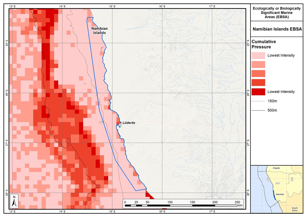
Map of cumulative pressure from all activities in the EBSA and surrounds. Darker reds indicate higher pressure intensity.
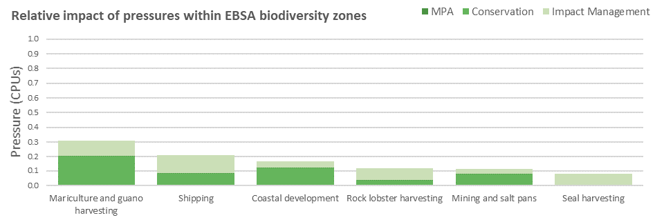
Pressure (in arbitrary cumulative pressure units, CPUs) summed for each pressure in the EBSA, per proposed EBSA biodiversity zone, ranked left (highest) to right (lowest) by the overall relative importance of pressures in this EBSA.
[Top]
Improved place-based protection of EBSA features should be pursued. In support of this, the EBSA is divided into a Conservation Zone and an Impact Management Zone, both comprising several areas within the EBSA. The aim of the Conservation Zone is to secure core areas of key biodiversity features in natural / near-natural ecological condition. Strict place-based biodiversity conservation is thus directed at securing key biodiversity features in a natural or semi-natural state, or as near to this state as possible. Activities or uses that have significant biodiversity impacts should be prohibited. Where possible and appropriate these areas should be considered for formal protection e.g., Marine Protected Areas or other effective area-based conservation measures (OECM). The aim of the Impact Management Zone is to manage negative impacts on key biodiversity features where strict place-based measures are not practical or not essential. In this zone, the focus is management of impacts on key biodiversity features in a mixed-use area, with the objective to keep biodiversity features in at least a functional state. Activities or uses which have significant biodiversity impacts should be strictly controlled and/or regulated. Within this zone, there should be no increase in the intensity of use or the extent of the footprint of activities that have significant biodiversity impacts. Where possible, biodiversity impacts should be reduced.
As far as possible, the Conservation Zone was designed deliberately to avoid conflicts with existing activities. The entire EBSA also falls under the protection of the Namibian Islands Marine Protected Area (NIMPA), with gazetted regulations available at the link below. Note that the proposed EBSA management recommendations are intended to inform a possible revision of these management regulations for NIMPA.
Proposed zonation of the EBSA into Conservation (medium green) and Impact Management (light green) Zones. MPAs are overlaid in orange outlines, with the extent within the EBSA given in dark green. Click on each of the zones to view the proposed management recommendations.
[Top]
Management regulations within the EBSA/MPA should also be applied to ensure that the existing activities/uses are appropriately controlled to ensure compatibility of activities with the environmental requirements for achieving the management objectives of the EBSA Conservation and Impact Management Zones. Further, no new pressures should be extended into the Conservation Zone, even if they currently occur in the Impact Management Zone of the EBSA.
Recommended compatibility (consent1 or prohibited2) of activities currently present in the EBSA3 in the Conservation and Impact Management Zones
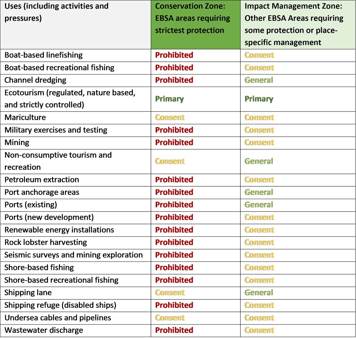
2Prohibited: An activity which is not allowed or should not be allowed because it is incompatible with maintaining the biodiversity objectives of the zone.1Consent: An activity which can continue in this zone subject to specific regulation and control.
*Not present in zone.
~Activity Prohibited but present in zone; need to confirm whether this needs to be kept, changed to Consent, or zone boundary changed.
3Note that activities present in Namibia that are not relevant to the EBSA have been excluded from the table (e.g., the harvested species does not occur in the area; or the industry operates at a depth outside the depth range of the EBSA).
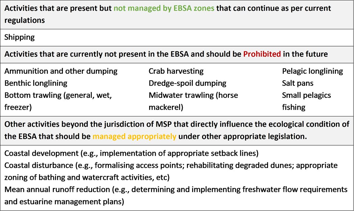
Furthermore, no new activities that can negatively impact the environment should be allowed in the EBSA, and some activities present in the EBSA do not need to be managed by EBSA zoning and can continue as per the current regulations. There are also some pressures on biodiversity features within the EBSA that originate from activities outside of these EBSA or beyond the jurisdiction of MSP. In support of maintaining the ecological integrity of and benefits delivered by the key biodiversity features, these other activities need to be appropriately managed by complementary initiatives.
Recommendations for other activities outside the EBSA or the MSP management jurisdiction.
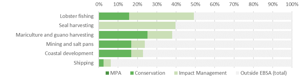
Proposed zonation of the EBSA, with the cumulative intensity footprint of activities within the EBSA (sorted highest to lowest) given relative to the national footprint of those activities to illustrate feasibility of management interventions.
Namibian Islands is a key area for five of the six activities that are present, with substantial portions of their respective national footprints occurring within the EBSA. Most notably, almost half of the country’s lobster harvesting takes place in Namibian Islands, mostly in the Impact Management Zone where it is recommended to continue as a Consent activity. It is recommended to be Prohibited in the Conservation Zone. Almost 40% of the country’s seal harvesting takes place in the Impact Management Zone of this EBSA. It is therefore recommended to continue as a Consent activity, but is recommended to be Prohibited in the Conservation Zone. Similarly, almost 40% of Namibia’s mariculture and guano harvesting take place in the EBSA. They are both recommended to continue in both the Conservation and Impact Management Zones as a Consent activity. Mining is a destructive activity that is not consistent with the management objectives of the Conservation Zone, and it thus recommended to be Prohibited in that zone. Recognising the economic importance of the activity, it accommodated for in the Impact Management Zone where it is recommended to continue as a Consent activity. Shipping is recommended to continue under current general rules and legislation; however, there might need to be some additional controls and regulations for shipping lanes and ship refuges. Other activities noted in the table of management recommendations above are either not currently present in the EBSA or are emerging activities; as far as possible, these are accommodated in the EBSA, depending on their compatibility with the management objectives of the two zones. Thus, the EBSA zonation has no or minimal impact on the national footprint for the listed marine activities.
There are also several activities that are largely outside the EBSA but have downstream impacts to the biodiversity within the EBSA, e.g., from mean annual runoff reduction, coastal development, coastal disturbance, and wastewater discharge. The impacts should be managed, but principally fall outside the direct management and zoning of the EBSA. These existing activities are proposed as Consent activities for both EBSA zones, recognising that they should ideally be dealt with in complementary integrated coastal zone management in support of the EBSA. For example, investment in eradicating the alien invasive species could aid in improving the ecological condition of rocky and mixed shores, improving benefits for subsistence and recreational harvesting; and rehabilitation of degraded dunes and formalising access points could support improved habitat for nesting shorebirds, and enhanced benefits for coastal protection during storm surges. Similarly, improved estuary management through development of appropriate freshwater flow requirements, estuarine management plans and wastewater management regulations can improve the ecological condition of the surrounding marine environment, in turn, improving water quality and safe conditions for human recreation.
Research Needs
There are no specific research needs for this EBSA over and above those listed for all EBSAs in general. Ongoing research and monitoring of key species within the Namibian Islands Marine Protected Area should be undertaken as part of reserve management to ensure effective management of the MPA. In particular, detailed knowledge of the spatial foraging ecology of the key seabird species currently at risk is imperative to understand comprehensively and to monitor.
Future Process
The most important future process in Namibian Islands is to strengthen effective management in the Namibian Islands MPA through full operationalisation and practical implementation of the proposed zoning and management regulations indicated above as part of the MPA and MSP processes in southern Namibia. Further, sufficient research and monitoring need to take place to ensure:
-
The status of key species and ecosystems within the MPA are better understood.
-
Conflicting activities are appropriately zoned both within and outside of the MPA.
-
The conservation effectiveness of the MPA is monitored on an ongoing basis to support appropriate adaptive management.
References
UNEP-WCMC, IUCN, 2022. Protected Planet: The World Database on Protected Areas (WDPA) and World Database on Other Effective Area-based Conservation Measures (WD-OECM) [Online], September 2022. UNEP-WCMC and IUCN, Cambridge, UK. Available at: www.protectedplanet.net.
Ministry of Fisheries and Marine Resources, 2022. The Central Marine Spatial Plan of Namibia. Windhoek: Namibia
[Top]